Log in
All resources
Create a design
38,713 Free Artworks of Map
bibliothèque nationale de france
tresor des cartes geographiques (1659)
beschreibung und contrafactur der vornembster stät der welt, liber primus civitates orbis terrarum
maps from the earth and its inhabitants, vol. vii
national library of poland
maps from the earth and its inhabitants, vol. x
maps from the earth and its inhabitants, vol. vi
charles eugène perron
maps from the earth and its inhabitants, vol. xvi
eran laor cartographic collection
cornelius aurelius world map
1510s maps of south america
demolished churches in de barbari map
santa maria dell'umiltà (venezia)
16th-century maps of venice
paolo forlani
too late for gordon and khartoum (1887) by macdonald
maps of the mahdist war
maps from the earth and its inhabitants, vol. xvii
french louisiana
maps from the earth and its inhabitants, vol. vi
charles eugène perron
maps from the earth and its inhabitants, vol. vii
yarlung tsangpo
maps from the earth and its inhabitants, vol. x
hannek
maps from the earth and its inhabitants, vol. x
lake tana
maps from the earth and its inhabitants, vol. xvi
jorullo
eran laor cartographic collection
guillaume sanson
eran laor cartographic collection
giovanni maria cassini
eran laor cartographic collection
guillaume sanson
maps of aragon and catalonia by mercator-hondius
spain in the 1600s
maps of eckernförde by braun & hogenberg
1620 in schleswig-holstein
mappe-monde geo-hydrographique (sanson and jaillot, 1674)
full size ferraris maps of belgium
emmanuel-jean-nepomucène de ghendt
voyages de la commission scientifique du nord, en scandinavie, en laponie, au spitzberg et aux feröe
maps of bossekop
old maps of spitsbergen
1642
de praecipvis totivs vniversi vrbibvs, liber secvndvs (1612)
maps of dunkerque by braun & hogenberg
atlas - voyage pittoresque à l'île-de-france, au cap de bonne-espérance et à l'île de ténériffe (1812) by milbert
maps from the mechanical curator collection
maps by pieter van der keere
old maps of friesland
maps in the library of congress
1790 maps
mountains and lakes in cumberland and westmoreland (1808)
maps in the british museum
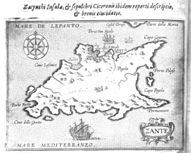
old maps of antikythera
old maps of kythira
theatri praecipvarvm totivs mvndi vrbivm : liber sextvs (1618)
maps of eisenstadt by braun & hogenberg
maps by thomas starling
1842 maps
maps of the islands of greece by marco boschini (1658)
old maps of lesbos
theatri praecipvarvm totivs mvndi vrbivm : liber sextvs (1618)
maps of čáslav by braun & hogenberg
grenzkarte der preussischen, russischen und oestreichischen monarchien (1796)
maps of pomerania province
maps of ancient italy by philipp clüver
maps of samnium
maps from gallica
old maps of rome
17th-century maps of the netherlands
maps by pieter van der keere
17th-century maps of savoie
old maps of savoie
maps of blois by braun & hogenberg
urbanisation in loir-et-cher
old maps of the shetland islands
old maps of the orkney islands
theatri praecipvarvm totivs mvndi vrbivm : liber sextvs (1618)
maps of dillenburg by braun & hogenberg
engravings of topographia braunschweig lüneburg
baroque
prints by frans hogenberg in the rijksmuseum amsterdam
maps in the rijksmuseum amsterdam
maps by nicolaes visscher i
1660s maps of europe
maps from the earth and its inhabitants, vol. ix
old maps of samsun
old maps of yosemite valley
john e. weyss
old maps of galicia (spain)
1834 in galicia (spain)
beschreibung und contrafactur der vornembster stät der welt, liber primus civitates orbis terrarum
maps of rhodes by braun & hogenberg
tresor des cartes geographiques (1659)
1650s maps of denmark
tresor des cartes geographiques (1659)
1650s maps of italy
tresor des cartes geographiques (1659)
1650s maps of china
bibliothèque nationale de france
sanson map of lorraine
tresor des cartes geographiques (1659)
1650s maps of ethiopia
beschreibung und contrafactur der vornembster stät der welt, liber primus civitates orbis terrarum
maps of vienna by braun & hogenberg
beschreibung und contrafactur der vornembster stät der welt, liber primus civitates orbis terrarum
maps of würzburg by braun & hogenberg
tresor des cartes geographiques (1659)
1650s maps of turkey
tresor des cartes geographiques (1659)
1650s maps of hungary
beschreibung und contrafactur der vornembster stät der welt, liber primus civitates orbis terrarum
maps of toledo by braun & hogenberg
beschreibung und contrafactur der vornembster stät der welt, liber primus civitates orbis terrarum
maps of dresden by braun & hogenberg
beschreibung und contrafactur der vornembster stät der welt, liber primus civitates orbis terrarum
maps of nîmes by braun & hogenberg
tresor des cartes geographiques (1659)
1650s maps of the americas
cartouches by willem and johannes blaeu
maps made in the 17th century
maps from the earth and its inhabitants, vol. x
rosetta (egypt)
maps from the earth and its inhabitants, vol. x
canals in egypt
maps from the earth and its inhabitants, vol. vii
qinghai lake
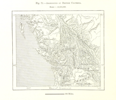
maps from the earth and its inhabitants, vol. xv
first nations people of british columbia
maps from the earth and its inhabitants, vol. xviii
transport in south america
maps from the earth and its inhabitants, vol. ii
st malo
maps from the earth and its inhabitants, vol. xii
sete cidades
maps from the earth and its inhabitants, vol. vi
pyatigorsk
maps from the earth and its inhabitants, vol. v
skaptar-jokull
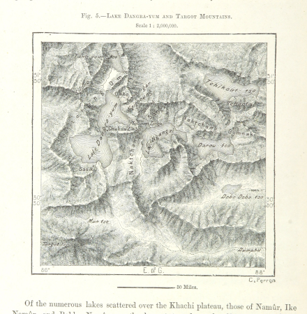
maps from the earth and its inhabitants, vol. vii
targot mountains
maps from the earth and its inhabitants, vol. xiii
mount kenya
illiteracy in france
education in france
maps from the earth and its inhabitants, vol. viii
ghats
maps of the dutch east india company - comoros
1665
maps from the earth and its inhabitants, vol. xvi
surveying in mexico
maps from the earth and its inhabitants, vol. viii
british india
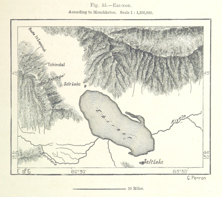
maps from the earth and its inhabitants, vol. vii
ebi lake
maps from the earth and its inhabitants, vol. vii
thomas edward gordon
maps from the earth and its inhabitants, vol. xviii
oscar drude
maps from the earth and its inhabitants, vol. ix
adana
maps from the earth and its inhabitants, vol. vi
deserts of asia
maps from the earth and its inhabitants, vol. xv
flora of alaska
maps from the earth and its inhabitants, vol. xvi
volcanism of mexico
maps from the earth and its inhabitants, vol. v
denmark in the 19th century
maps from the earth and its inhabitants, vol. xv
flora of canada
cartography
maps
cartography
maps
cartography
maps
françois de la pointe
maps of barbary coast
maps published by hendrik de leth
algiers in the 18th century
old maps of the strait of gibraltar
hendrik de leth
atlas - voyage pittoresque à l'île-de-france, au cap de bonne-espérance et à l'île de ténériffe (1812) by milbert
maps from the mechanical curator collection
atlas ou representation du monde universel t. 2 (1633)
maps by hendrik hondius the younger
dutch 17th-century prints in the rijksmuseum amsterdam
maps by daniel stoopendaal
maps in the national library of australia
map of paris by claes jansz. visscher
sconces in the netherlands
maps by isaak tirion
1878 in switzerland
maps of bremgarten
maps of bremen by braun & hogenberg
maps made in the 16th century
nieuwe en beknopte hand-atlas (1754)
old maps of curaçao
maps from encyclopædia britannica
emery walker
old maps of southeast asia
maps by isaak tirion
maps of portugal by fernando álvares seco
theatrum orbis terrarum (1606 folger)
19801 - 19900 of 38,713
Next page
/ 388


![Beschreibung und Contrafactur der Vornembster stät der Welt, liber primus [Civities of the World], 1574](https://cdn.creazilla.com/illustrations/10000199581/beschreibung-und-contrafactur-der-vornembster-stt-der-welt-liber-primus-civities-of-the-world-1574-sm.webp)
![Treasure of geographical maps of the main states of the universe [...], 1659](https://cdn.creazilla.com/illustrations/10000314824/treasure-of-geographical-maps-of-the-main-states-of-the-universe-1659-sm.webp)
![Treasure of geographical maps of the main states of the universe [...], 1659](https://cdn.creazilla.com/illustrations/10000521357/treasure-of-geographical-maps-of-the-main-states-of-the-universe-1659-md.jpg)
![Treasure of geographical maps of the main states of the universe [...], 1659](https://cdn.creazilla.com/illustrations/10000420918/treasure-of-geographical-maps-of-the-main-states-of-the-universe-1659-md.jpg)

![Treasure of geographical maps of the main states of the universe [...], 1659](https://cdn.creazilla.com/illustrations/10000449944/treasure-of-geographical-maps-of-the-main-states-of-the-universe-1659-sm.webp)
![Beschreibung und Contrafactur der Vornembster stät der Welt, liber primus [Civities of the World], 1574](https://cdn.creazilla.com/illustrations/10000603472/beschreibung-und-contrafactur-der-vornembster-stt-der-welt-liber-primus-civities-of-the-world-1574-sm.webp)
![Beschreibung und Contrafactur der Vornembster stät der Welt, liber primus [Civities of the World], 1574](https://cdn.creazilla.com/illustrations/10001109590/beschreibung-und-contrafactur-der-vornembster-st-t-der-welt-liber-primus-civities-of-the-world-1574-sm.jpg)
![Treasure of geographical maps of the main states of the universe [...], 1659](https://cdn.creazilla.com/illustrations/10001323164/treasure-of-geographical-maps-of-the-main-states-of-the-universe-1659-sm.webp)
![Treasure of geographical maps of the main states of the universe [...], 1659](https://cdn.creazilla.com/illustrations/10001410826/treasure-of-geographical-maps-of-the-main-states-of-the-universe-1659-sm.webp)
![Beschreibung und Contrafactur der Vornembster stät der Welt, liber primus [Civities of the World], 1574](https://cdn.creazilla.com/illustrations/10000869625/beschreibung-und-contrafactur-der-vornembster-stt-der-welt-liber-primus-civities-of-the-world-1574-sm.webp)
![Beschreibung und Contrafactur der Vornembster stät der Welt, liber primus [Civities of the World], 1574](https://cdn.creazilla.com/illustrations/10001235664/beschreibung-und-contrafactur-der-vornembster-stt-der-welt-liber-primus-civities-of-the-world-1574-sm.webp)
![Beschreibung und Contrafactur der Vornembster stät der Welt, liber primus [Civities of the World], 1574](https://cdn.creazilla.com/illustrations/10001559172/beschreibung-und-contrafactur-der-vornembster-stt-der-welt-liber-primus-civities-of-the-world-1574.jpg)
![Treasure of geographical maps of the main states of the universe [...], 1659](https://cdn.creazilla.com/illustrations/10001567991/treasure-of-geographical-maps-of-the-main-states-of-the-universe-1659-sm.jpg)


![Gerardi Mercatoris and I. Hondii Atlas or Representation of the Universal World, and of the Parts of It, Made in Tables and Very Ample Descriptions. [t. 2].](https://cdn.creazilla.com/illustrations/10000421870/gerardi-mercatoris-and-i-hondii-atlas-or-representation-of-the-universal-world-and-of-the-parts-of-it-made-in-tables-and-very-ample-descriptions-t-2-md.jpg)


