Log in
All resources
Create a design
38,713 Free Artworks of Map
eran laor cartographic collection
bibliothèque nationale de france
latin-language maps
the comprehensive history of england (1876)
english-language maps showing history
1870s maps showing history
richard william seale
national library of poland
maps by willem and johannes blaeu
willem blaeu
corona and coronet (1898)
1898 maps of the world
the comprehensive history of england (1876)
english-language maps showing history
the comprehensive history of england (1876)
english-language maps showing history
the comprehensive history of england (1876)
english-language maps showing history
1870s maps of egypt
1879 maps of africa
the comprehensive history of england (1876)
english-language maps showing history
the comprehensive history of england (1876)
english-language maps showing history
too late for gordon and khartoum (1887) by macdonald
maps of the mahdist war
the comprehensive history of england (1876)
english-language maps showing history
the comprehensive history of england (1876)
english-language maps showing history
the comprehensive history of england (1876)
english-language maps showing history
the comprehensive history of england (1876)
english-language maps showing history
the comprehensive history of england (1876)
english-language maps showing history
the comprehensive history of england (1876)
english-language maps showing history
beschreibung der städt der welt - braun & hogenberg - btv1b52512111k
maps of konstanz by braun & hogenberg
beschreibung der städt der welt - braun & hogenberg - btv1b52512111k
maps of burgos by braun & hogenberg
beschreibung der städt der welt - braun & hogenberg - btv1b52512111k
maps of cusco by braun & hogenberg
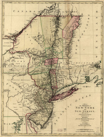
a map of the provinces of new york and new jersey, with a part of pennsylvania and the province of quebec
maps in the library of congress
maps by nicolas sanson
maps from gallica
maps by takeshiro matsuura
old maps of ezo
maps by willem and johannes blaeu
old maps of dunkerque
maps of venlo by willem and johannes blaeu
distelmolen (venlo)
print room of the university of antwerp
plattegrond van antwerpen
speculum romanae magnificentiae (mirror of roman magnificence)
sebastiano del re
print room of the university of antwerp
citadel van antwerpen
details of old maps of amsterdam
jan roodenpoortstoren
media from accademia delle scienze di torino
1579 illustrations
maps of asia by mercator-hondius
nieuwe en beknopte hand-atlas (1754)
18th-century maps of martinique
17th-century maps of mecklenburg-vorpommern
maps of rügen by eilhard lubinus
18th-century maps of istanbul
1771 maps of turkey
arnold van langren map of east africa
1600 maps of africa
maps of hamburg by braun & hogenberg
maps of lübeck by braun & hogenberg
maps by pieter van der keere
17th-century maps of silesia
charts and maps of the royal museums greenwich
1693 maps
carte de l'amérique septentrionale by guillaume delisle (1700)
1700 maps of north america
eran laor cartographic collection
johann ulrich krauß
eran laor cartographic collection
jacob peeters
maps of gallipoli by braun & hogenberg
maps in the british museum
eran laor cartographic collection
willem blaeu
eran laor cartographic collection
alain manesson-mallet
eran laor cartographic collection
willem blaeu
eran laor cartographic collection
nicolaus van aelst
eran laor cartographic collection
william hughes (geographer)
eran laor cartographic collection
romanticism
eran laor cartographic collection
william hughes (geographer)
eran laor cartographic collection
theodor de bry
illustrations from the mysterious island by jules férat
maps of the mysterious island
17th-century engravings
johannes de ram
eran laor cartographic collection
william dickes
eran laor cartographic collection
pieter van der keere
eran laor cartographic collection
willem blaeu
eran laor cartographic collection
giovanni maria cassini
eran laor cartographic collection
giovanni maria cassini
details of images of venice by jacopo de' barbari
jacopo de' barbari
1780s maps of berlin
1786 maps of berlin
17th-century double hemisphere world maps
mercator 1587 world map
17th-century maps of scotland
maps of islay
maps of circumnavigations of the world
1740s maps of the world
de praecipvis totivs vniversi vrbibvs, liber secvndvs (1612)
maps of tunis by braun & hogenberg
de praecipvis totivs vniversi vrbibvs, liber secvndvs (1612)
maps of methoni by braun & hogenberg
atlas minor gerardi mercatoris (1609)
maps of europe by mercator-hondius
chorographia britanniae (1741-1742)
18th-century maps of essex
prints by abraham allard in the rijksmuseum amsterdam
1700s maps of spain
maps in the rijksmuseum amsterdam
johannes de ram
1821 maps of the united states
maps by john cary
map of italy by guillaume delisle (1700)
1700 maps of italy
dominikanerkloster (frankfurt)
judengasse (frankfurt)
eran laor cartographic collection
pierre françois tardieu
claes jansz. visscher (ii)
atlas van stolk
maps in the library of congress
emory place historic district
atlas vingboons
1665
mountains and lakes in cumberland and westmoreland (1808)
maps in the british museum
theatri praecipvarvm totivs mvndi vrbivm : liber sextvs (1618)
maps of poznań by braun & hogenberg
old maps of bourbonnais
1660s maps of france
maps by hendrik hondius the younger
1632 maps of africa
john rocque 1746 crops from library of congress
john rocque's maps of london
maps of the peloponnese by gerardus mercator
1640s maps of greece
theatri praecipvarvm totivs mvndi vrbivm : liber sextvs (1618)
maps of biecz by braun & hogenberg
guida illustrata di montepiano e sue adiacenze (1892)
books from biblioteca lazzerini di prato
prints by frans hogenberg in the rijksmuseum amsterdam
maps in the rijksmuseum amsterdam
celeberrimi fluvii albis nova delineatio by willem janszoon blaeu
maps in the staats- und universitätsbibliothek hamburg
john rocque's 1748 map of london and adjacent country
bibliothèque nationale de france
bibliothèque nationale de france
maps by thomas kitchin
maps in the rijksmuseum amsterdam
old maps of franeker
maps by bernard ratzer
maps by thomas kitchin
eran laor cartographic collection
bernardino amico
eran laor cartographic collection
richard william seale
eran laor cartographic collection
richard william seale
eran laor cartographic collection
alexis-hubert jaillot
eran laor cartographic collection
johann ulrich krauß
bibliothèque nationale de france
maps of goa by linschoten
eran laor cartographic collection
philippe de la rué
eran laor cartographic collection
richard william seale
eran laor cartographic collection
richard william seale
georg balthasar probst (1732-1801)
eran laor cartographic collection
the gazetteer of scotland (1838)
william home lizars
portrait paintings of men in the rijksmuseum amsterdam
american paintings in the rijksmuseum amsterdam
old maps of breda, netherlands
adriaen jan bogaerts
map of maastricht by willem and johannes blaeu (1649)
sint-maartenspoort (maastricht, gate)
19701 - 19800 of 38,713
Next page
/ 388