Log in
All resources
Create a design
38,713 Free Artworks of Map
truscott map of st-petersburg 1753
ivan sokolov
eran laor cartographic collection
bibliothèque nationale de france
maps of africa
gemeente atlas van nederland - south holland
1860s maps of south holland
maps in the library of congress
french-language maps
frans hogenberg
maps in the library of congress
1713 maps
1809 maps of saxony-anhalt
1809 maps of saxony
west seram regency
johannes nessel
atlas maior, vol 4 (netherlands) - joan blaeu, 1667 - bl 114.h(star).4
1667 maps
1803 in berlin
1803 maps
gemeente atlas van nederland - drenthe
drenthe
old maps of virginia
p.s. duval & son
maps by matthäus merian
baroque
1830 maps of the united states
maps by george w. boynton
eran laor cartographic collection
william henry toms
eran laor cartographic collection
joseph franz kaiser
eran laor cartographic collection
willem albert bachiene
eran laor cartographic collection
engravings by frans hogenberg
eran laor cartographic collection
tranquillo mollo
maps by macdonald gill
royal mail
the comprehensive history of england (1876)
english-language maps showing history
maps made in the 17th century
old maps of china
old maps of the dutch east india company
1705
maps of mombasa by braun & hogenberg
maps of cefala by braun & hogenberg
maps of the province of ávila
1769 maps of spain
17th-century maps of saxony
1690s maps of saxony
maps of the forest of fontainebleau
old maps of seine-et-marne
1375 maps of europe
catalan atlas
truscott map of st-petersburg 1753
ivan sokolov
truscott map of st-petersburg 1753
ivan sokolov
truscott map of st-petersburg 1753
ivan sokolov
truscott map of st-petersburg 1753
ivan sokolov
truscott map of st-petersburg 1753
ivan sokolov
maps of liège by johannes blaeu - derivative files
église saint-remacle (liège)
truscott map of st-petersburg 1753
ivan sokolov
truscott map of st-petersburg 1753
ivan sokolov
truscott map of st-petersburg 1753
ivan sokolov
turgot map of paris, kyoto university library – derivative files
collège du plessis
curt teich postcard archives
map postcards
1910 maps of hamburg
emery walker
maps from the earth and its inhabitants, vol. x
maps of africa
gemeente atlas van nederland - south holland
old maps of gouda
maps from the mechanical curator collection
australia (1873) by booth
maps of linden (hannover)
lindener berg (hannover)
cartes de franz schrader
maps of algeria by theme
southwark, philadelphia
sparks shot tower
17th-century maps of the iberian peninsula
description de l'universe
map of paris by braun & hogenberg - derivative files
rue des archives (paris)
print room of the university of antwerp
citadel van antwerpen
17th-century maps of south america
description de l'universe
siege of győr (1598) in art
1602 books
20th-century maps of battles
battle of mondovi
maps from the earth and its inhabitants, vol. xii
africa in the 1890s
maps of paris by braun & hogenberg
maps of paris from paris musées
situs terrae promissionis by christian van adrichom
christian van adrichem
1942 watercolor paintings
works by eric ravilious
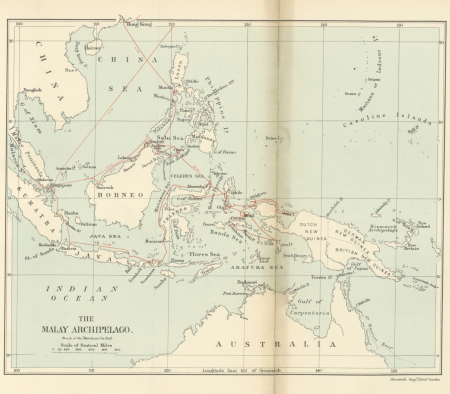
19th-century maps of the malay archipelago
the cruise of the marchesa (1889)
maps from the earth and its inhabitants, vol. xii
africa in the 1890s
gemeente atlas van nederland - south holland
maps of groot-ammers
maps from the earth and its inhabitants, vol. x
1890 maps of africa
gemeente atlas van nederland - south holland
maps of zuid-beijerland
romania in the 17th century
danubius pannonico-mysicus
maps from the earth and its inhabitants, vol. iv
topographic maps of ireland
maps from the earth and its inhabitants, vol. xv
19th-century maps of british columbia
german renaissance,northern renaissance
1500 maps
maps of ghent by hendrik hondius
nrcs new york (state) distribution maps
eschscholzia californica (cultivated)
maps by willem and johannes blaeu
old maps of the ottoman empire
the story of mexico (1889 book)
1880s maps of mexico
maps in the library of congress
1785 maps
lordship of mechelen
1645 maps of belgium
eran laor cartographic collection
sanson maps of asia
nicolaas samuel crucquius
old maps of delfland
maps of hamburg-altstadt
1588 maps of hamburg
maps in the library of congress
1866 maps of pennsylvania
maps by thomas kitchin
1781 maps of europe
old maps of china in harvard map collection
1749 maps of asia
italia - di matteo greuter... - btv1b525056959
old maps of apulia
den danske hærs historie til nutiden og den norske hærs historie indtil 1814
maps from the mechanical curator collection
truscott map of st-petersburg 1753
ivan sokolov
truscott map of st-petersburg 1753
ivan sokolov
truscott map of st-petersburg 1753
ivan sokolov
maps by christian sgrothen
old maps of zeeland
truscott map of st-petersburg 1753
ivan sokolov
truscott map of st-petersburg 1753
ivan sokolov
truscott map of st-petersburg 1753
ivan sokolov
maps of hamburg by braun & hogenberg
maps of hamburg-altstadt
maps of mons city walls (hainaut)
old maps of mons (hainaut)
maps by pieter van der keere
maps by abraham ortelius
eran laor cartographic collection
pierre françois tardieu
maps from the mechanical curator collection
australia (1873) by booth
maps from the earth and its inhabitants, vol. x
maps of africa
german-language maps of the balkans
1910s maps of albania
old maps of the london borough of southwark
john rocque's 1746 map of london
gemeente atlas van nederland - south holland
old maps of gouda
old maps of hindeloopen
baroque
1677 maps of asia
georg widmann
truscott map of st-petersburg 1753
ivan sokolov
truscott map of st-petersburg 1753
ivan sokolov
truscott map of st-petersburg 1753
ivan sokolov
truscott map of st-petersburg 1753
ivan sokolov
truscott map of st-petersburg 1753
ivan sokolov
truscott map of st-petersburg 1753
ivan sokolov
propaganda map
maps by christian sgrothen
old maps of zeeland
14701 - 14800 of 38,713
Next page
/ 388


![[Map of the castellania of Gent], Joan Blaeu, 1667](https://cdn.creazilla.com/illustrations/10000630608/map-of-the-castellania-of-gent-joan-blaeu-1667-md.jpg)