Log in
All resources
Create a design
38,713 Free Artworks of Map
bibliothèque nationale de france
gemeente atlas van nederland - south holland
1860s maps of south holland
maps in the library of congress
maps in the british museum
paper
british museum
maps from university of amsterdam special collections
atlas der neederlanden
copperplate print
18th-century maps of edinburgh-shire
maps of scotland by herman moll
maps in the british museum
georg friedrich schmidt
hoogheemraadschap van rijnland
maps of woubrugge
1572 in london
1572 maps
gemeente atlas van nederland - south holland
maps of piershil
gemeente atlas van nederland - south holland
maps of goudswaard
17th-century maps of cornwall
maps in the british museum
maps in the library of congress
1718 maps
maps by gerard de jode
1593 maps of africa
perris maps of manhattan published 1852–1853
neoclassicism
atlas van der hagen (volume 4)
atlas van der hagen
maps from university of amsterdam special collections
atlas der neederlanden
maps of the malay archipelago by mercator-hondius
map of bruges by marcus gheeraerts (i)
sint-gilliskwartier
old maps of freiburg im breisgau
emery walker
tōzai ezo sansen chiri torishirabezu
oshima peninsula
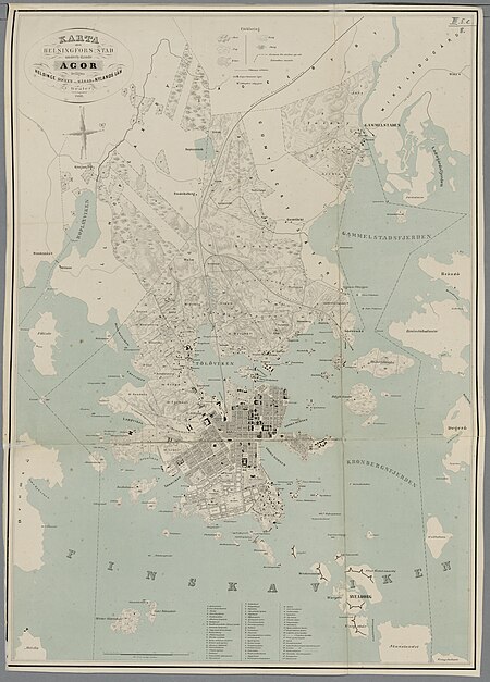
media from the national library of finland
classicism
maps of spain by tomas lopez
old maps of guadeloupe
maps of sterrenburg (utrecht)
atlas van loon
maps of paris from the david rumsey historical map collection
plan de roussel
joseon dynasty
heo mok
maps from kiesslings wanderbuch für die mark brandenburg
1898 in berlin
maps of the arctic by gerardus mercator
maps by hendrik hondius the younger
maps in the staats- und universitätsbibliothek hamburg
1841 maps of hamburg
carte de la mer mediterranée (1764) by roux
eran laor cartographic collection
maps of the duchy of berg
maps by gerard valck
maps of paris by braun & hogenberg
maps of paris from paris musées
maps in the library of congress
1769 maps of europe
maps in the library of congress
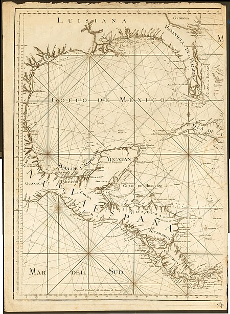
1771 maps of north america
gemeente atlas van nederland - north holland
maps of beemster
maps by thomas kitchin
1750s maps of germany
1780s maps of the caribbean
maps in the british museum
18th-century maps of the canary islands
maps of spain by tomas lopez
maps by edward wright
molyneux globes
old images of crete under venetian rule
old maps of chania
old maps of north rhine-westphalia
maps of balve
18th-century maps of the canary islands
maps of spain by tomas lopez
maps by thomas kitchin
1750s maps of germany
1739 maps of france
louis bretez
nypl collection of atlases, gazetteers, guidebooks and other books
nypl lionel pincus and princess firyal map division
former theatres in boston
boston in the 1910s
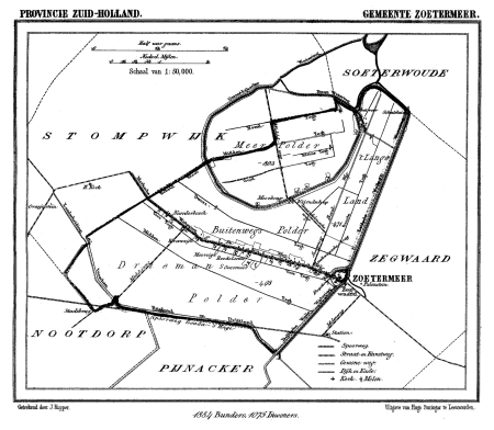
gemeente atlas van nederland - south holland
maps of zoetermeer
curt teich postcard archives
map postcards
itinerario (jan huygen van linschoten)
16th-century maps of java
maps from the earth and its inhabitants, vol. x
maps with nicolosi globular projection
1895 maps of new york (state)
old maps of albany, new york
curt teich postcard archives
maps of arizona in art
old maps of samegrelo
cornelis de jode
old maps of coevorden
atlas van loon
18th-century maps of antarctica
1741 maps
maps of the dutch east india company - indonesia
18th-century maps of java
gemeente atlas van nederland - south holland
1860s maps of south holland
maps from the earth and its inhabitants, vol. xiii
africa in the 1890s
gemeente atlas van nederland - utrecht
maps of oudewater
palau in the 18th century
old maps of palau
carte de moscovie by guillaume de l'isle (1706)
eran laor cartographic collection
arnold van langren map of southwest africa
1596 maps of africa
juan de la cruz cano y olmedilla
maps by tomas lopez
juan de la cruz cano y olmedilla
maps by tomas lopez
maps of brugse vrije by pieter pourbus
pieter pourbus
maps of paris from bibliothèque nationale de france
ludovic baschet
maps of polders in south holland
18th-century maps of rotterdam
maps of brest from bibliothèque nationale de france
brest (france) in the 1700s
engravings of topographia braunschweig lüneburg
baroque
maps of valenciennes city walls
old maps of valenciennes
english-language maps of africa
maps by emanuel bowen
gemeente atlas van nederland - south holland
maps of lisse
historisk atlas (stockholm, norstedt & söner, 1880)
maps of 13th-century greece
maps from the earth and its inhabitants, vol. x
19th-century maps of africa
maps by willem and johannes blaeu
maps of montfoort
old maps of japan
kimura kenkado
maps from the earth and its inhabitants, vol. x
maps of damietta
university of amsterdam
map of amsterdam, 1544
maps from university of amsterdam special collections
atlas der neederlanden
miniature speed atlas (1627) pieter van den keere
old county maps of lancashire
miniature speed atlas (1627) pieter van den keere
1620s maps of wales
1710s maps of eastern europe
muscovy
18th-century maps of antwerp
anna beeck
broomfields, bradford
robert dawson
media from regionaal archief alkmaar
maps of barsingerhorn
guide joanne normandie-1912
1912 maps of france
maps from gallica
old maps of psarà
18th-century maps of veneto
1700s maps of slovenia
john rocque 1746 crops from library of congress
john rocque
maps by willem and johannes blaeu
1630s maps of the caucasus
old maps of tierra del fuego
description de l'universe
19th-century maps of dresden
johanniskirche (dresden)
old maps of delfland
maps of maassluis
hamburgische elbkarte von melchior lorichs
parts of old maps of hamburg
maps from university of amsterdam special collections
atlas der neederlanden
maps in the library of congress
1852 maps of massachusetts
maps of the ural mountains
russia (1913)
maps by gerardus mercator
kempen (region)
prints in the staats- und stadtbibliothek augsburg
16th-century maps of augsburg
maps from the earth and its inhabitants, vol. vi
1891 maps of georgia
map of bruges by marcus gheeraerts (i)
drawings in the groeningemuseum
18th-century maps of the indian ocean
bodleian maps collection
maps in the library of congress
1830s maps of china
pieter schenk (ii)
old maps of saxony
maps in the library of congress
1713 maps
14601 - 14700 of 38,713
Next page
/ 388


![Voorne Land Map - Dutch Municipal Boundaries, 1695, Romeyn de Hooghe, [1701]](https://cdn.creazilla.com/illustrations/10000511069/voorne-land-map-dutch-municipal-boundaries-1695-romeyn-de-hooghe-1701-md.jpg)


![From Sio and Psara / [by Allain Manesson-Mallet], 1683](https://cdn.creazilla.com/illustrations/10001127472/from-sio-and-psara-by-allain-manesson-mallet-1683-sm.webp)


![Map of the polder of Oost Voorn / Heyman van Dyck fecit 1695; A. Steyaart invented; I. Stemmer's sculpsit; I. Shutters fecit cum aqua forti, Romeyn de Hooghe, [1701]](https://cdn.creazilla.com/illustrations/10000729215/map-of-the-polder-of-oost-voorn-heyman-van-dyck-fecit-1695-a-steyaart-invented-i-stemmers-sculpsit-i-shutters-fecit-cum-aqua-forti-romeyn-de-hooghe-1701-md.jpg)


![[The Coast of Mallabar by John Corner, 1741], John Corner](https://cdn.creazilla.com/illustrations/10000515559/the-coast-of-mallabar-by-john-corner-1741-john-corner-md.jpg)


