Log in
All resources
Create a design
38,713 Free Artworks of Map
bibliothèque nationale de france
gemeente atlas van nederland - north holland
1860s maps of north holland
maps by willem and johannes blaeu
gemeente atlas van nederland - south holland
1860s maps of south holland
lawrence h. slaughter collection of english maps, charts, globes, books and atlases
a map of the provinces of new york and new jersey, with a part of pennsylvania and the province of quebec
maps from the earth and its inhabitants, vol. x
eran laor cartographic collection
chicago and the midwest, newberry library
illinois & michigan canal
maps showing 19th-century history
isaiah thomas (publisher)
maps by tomas lopez
1785 maps of africa
17th-century maps of slovenia
1642 maps
maps of south america by mercator-hondius
maps in the biblioteca nacional do brasil
18th-century maps of zeeland
county of zeeland
gemeente atlas van nederland - south holland
old maps of leiden
a map of the provinces of new york and new jersey, with a part of pennsylvania and the province of quebec
lawrence h. slaughter collection of english maps, charts, globes, books and atlases
a map of the provinces of new york and new jersey, with a part of pennsylvania and the province of quebec
lawrence h. slaughter collection of english maps, charts, globes, books and atlases
maps showing 19th-century history
1812 maps of africa
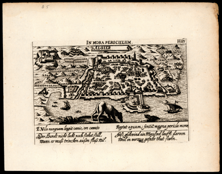
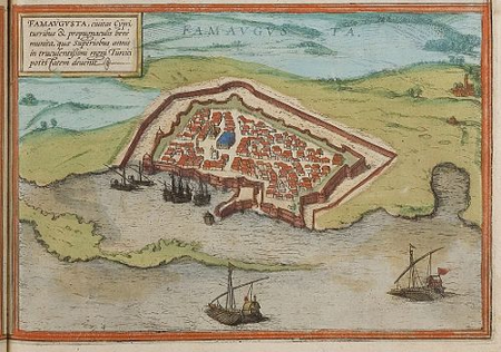
maps of famagusta by braun & hogenberg
list of cities with defensive walls
old maps of regions of poland
starachowice
english-language maps
maps by john cary
maps made in the 17th century
johannes van keulen
maps of antwerp city walls
old maps of antwerp
eran laor cartographic collection
cornelis de bruyn
18th-century portrait paintings in tate britain
male portrait paintings by francis cotes
18th-century maps of the bahamas
18th-century maps of hispaniola
maps of cagliari by braun & hogenberg
maps of valletta by braun & hogenberg
maps by willem and johannes blaeu
old maps of delft
maps by wilhelm maximilian carpelan
stockholmsvägen, lidingö
19th-century portrait paintings in the musée national du château de versailles
jean charles nicaise perrin
topographia braunschweig lüneburg (merian)
baroque
1794 rocque wall map of ireland
county clare
maps of frankfurt (oder) by braun & hogenberg
maps of wittenberg by braun & hogenberg
1762 maps of north america
maps by tomas lopez
maps from the earth and its inhabitants, vol. iv
topographic maps of the united kingdom
old maps of la gomera
1878 maps of spain
maps from the earth and its inhabitants, vol. xii
19th-century maps of senegal
maps from the earth and its inhabitants, vol. iv
old maps of the lake district
drawings in the museu antônio parreiras
graphite
1572 maps of africa
1570s maps of egypt
brazilian paintings in the museu antônio parreiras
wood
old maps of ghent by jacques horenbault
old maps of sint-elisabethbegijnhof
description de l'universe
1685 maps of europe
maps from the earth and its inhabitants, vol. xiii
maps of weather and climate of south africa
maps from the earth and its inhabitants, vol. xv
19th-century maps of british columbia
maps from the earth and its inhabitants, vol. xiv
1870s maps of new zealand
antoine-françois tardieu
jean-baptiste poirson
1880s maps of tunisia
maps from gallica
johann friedrich walther
1738 in berlin-mitte
maps by willem and johannes blaeu
old maps of zierikzee
historical images of somalia
fra mauro map details
old maps of the stations of the exodus
joan blaeu
1779 maps of new york (state)
old maps of new york (state)
maps of the land of oz
1914 maps
a map of the provinces of new york and new jersey, with a part of pennsylvania and the province of quebec
lawrence h. slaughter collection of english maps, charts, globes, books and atlases
margraviate of moravia (1628-1782)
coats of arms on maps
palatinatus rheni (merian)
baroque
gemeente atlas van nederland - utrecht
ruwiel
maps of helsingborg by braun & hogenberg
maps of lund by braun & hogenberg
old maps of henan
maps with figures
eran laor cartographic collection
pierre mortier
madrid in the 1820s
maps by juan lopez
cartes de franz schrader
old maps of the alps
demolished churches in de barbari map
san daniele (venice)
maps from university of amsterdam special collections
atlas der neederlanden
the history and antiquities of the parish of lambeth, and the archiepiscopal palace (1827)
soil science maps
admiralty charts region r: usa and mexico west coasts
admiralty charts 401-600
maps from university of amsterdam special collections
atlas der neederlanden
a map of the provinces of new york and new jersey, with a part of pennsylvania and the province of quebec
lawrence h. slaughter collection of english maps, charts, globes, books and atlases
gemeente atlas van nederland - south holland
maps of wassenaar
gemeente atlas van nederland - south holland
1860s maps of south holland
maps of ireland by baptista boazio
maps in the library of congress
gemeente atlas van nederland - south holland
1860s maps of south holland
gemeente atlas van nederland - north holland
maps of texel
17th-century maps of the black sea
maps by willem and johannes blaeu
maps from the earth and its inhabitants, vol. x
1890 maps of africa
gemeente atlas van nederland - south holland
1860s maps of south holland
gemeente atlas van nederland - north holland
old maps of haarlem
maps of ireland by baptista boazio
maps in the library of congress
maps from the earth and its inhabitants, vol. x
1890 maps of africa
gemeente atlas van nederland - north holland
maps of bloemendaal
maps from the earth and its inhabitants, vol. iv
geological maps of the united kingdom
maps by jacques-nicolas bellin
1773 maps
maps of the iberian peninsula by guillaume delisle
1700s maps of the iberian peninsula
maps in the staats- und universitätsbibliothek hamburg
1588 maps of hamburg
1800s maps of the iberian peninsula
maps of spain by tomas lopez
maps from the earth and its inhabitants, vol. x
1890 in cairo
drawings in the museu antônio parreiras
paper
göteborg harbour
nya varvet
maps in the british museum
hitchin herts
flandria illustrata
old maps of lille
1912 maps of the ottoman empire
1910s maps of the balkans
gemeente atlas van nederland - north holland
old maps of alkmaar
maps in the library of congress
1852 maps
old maps of somaliland
zeila
gemeente atlas van nederland - north holland
1860s maps of north holland
1898 covers of puck magazine
drawings of scissors
eran laor cartographic collection
thesaurus philopoliticus
catalan atlas
old maps of baghdad
matrakçı nasuh
maps of speyer by braun & hogenberg
maps of worms by braun & hogenberg
maps of málaga by braun & hogenberg
maps of cadiz by braun & hogenberg
19th-century maps of charente
1842 maps
maps by willem and johannes blaeu
history of kotlas
map of ghent by lucas de heere
lucas de heere
1650s maps of the americas
1658 maps
maps from the earth and its inhabitants, vol. x
1890 maps of africa
gemeente atlas van nederland - north holland
maps of muiden
14801 - 14900 of 38,713
Next page
/ 388


![Calaris; Malta; Rhodes; Famagusta / [Georg Braun]; [Franz Hogenberg]](https://cdn.creazilla.com/illustrations/10000490984/calaris-malta-rhodes-famagusta-georg-braun-franz-hogenberg-md.jpg)


![Map or drawing of the river Merwede from Gorichem downwards etc. / [Nicolaes Cruquius], [1730]](https://cdn.creazilla.com/illustrations/10000781010/map-or-drawing-of-the-river-merwede-from-gorichem-downwards-etc-nicolaes-cruquius-1730-sm.webp)


![Map or drawing of the river Merwede from Gorichem downwards etc. / [Nicolaes Cruquius], [1730]](https://cdn.creazilla.com/illustrations/10001543119/map-or-drawing-of-the-river-merwede-from-gorichem-downwards-etc-nicolaes-cruquius-1730-md.jpg)