Log in
All resources
Create a design
38,713 Free Artworks of Map
maps by willem and johannes blaeu
eran laor cartographic collection
coats of arms on maps
latin-language maps
joan blaeu
atlas van loon
jodocus hondius ii, nova totius terrarum orbis geographica ac hydrographica tabula, 1636
world map
national library of israel
old maps of haarlem
fra mauro map details
1450s maps of europe
haarlem nautz map 1822-1829
old maps of haarlem
old maps of zwartsluis
zwarte water
old maps of the polish-lithuanian commonwealth
17th-century maps of prussia
maps in the library of congress
1889 maps of new york (state)
17th-century maps of africa
maps from gallica
maps in the library of congress
1886 maps of new york (state)
media from the national library of finland
classicism
victor levasseur - maps of france
old maps of meurthe (department)
18th-century maps of the caspian sea
1720s maps of the russian empire
maps by willem and johannes blaeu
copper engravings
old maps of shaanxi
animals on maps
maps in the library of congress
1849 maps of philadelphia
maps of midden-delfland
foppenpolder
cityscapes of duluth, minnesota
lake freighters
old maps of la rioja (spain)
1769 maps of spain
maps in the library of congress
novus atlas sinensis
maps of the county of flanders
county of zeeland
ptolemy's second projection
emery walker
maps by willem and johannes blaeu
1630s maps of the world
17th-century maps of frankfurt am main
maps by willem and johannes blaeu
media from the national library of finland
classicism
jodocus hondius ii, nova totius terrarum orbis geographica ac hydrographica tabula, 1636
eran laor cartographic collection
old maps of roermond
upper guelders
baroque
fizzo
old maps of heemstede, north holland
old maps of haarlem
1660s maps of spain
1667 maps
media from the national library of finland
classicism
maps by john cary
1806 maps of asia
maps of san juan, puerto rico
san juan bay, puerto rico
1790s maps of central america
1790s maps of cuba
maps by willem and johannes blaeu
siege of breda 1624-1625
russian empire in thomas kitchen's general atlas (1773)
general atlas (1773)
old county maps of lancashire
copper engravings
maps from the earth and its inhabitants, vol. xii
old maps of guinea
cornell's primary geography (1860)
1867 maps of canada
island of california on world maps
1650s maps of the world
maps from the mechanical curator collection available to georeference
maps from the mechanical curator collection
1660s maps of belgium
old maps of bruges
maps of rotterdam by berckenrode
atlas van loon
17th-century maps of south america
maps by nicolas sanson
1934 maps of massachusetts
pictorial maps
salzkammergut in upper austria
maps of salzkammergut
nürnberger reichswald
1559 maps of germany
sanborn maps of manhattan published in 1904
old maps of west houston street (manhattan)
maps of nuremberg by braun & hogenberg
eran laor cartographic collection
maps from the mechanical curator collection
through the subarctic forest (1896) by pike
statue of josé gervasio artigas (washington, d.c.)
maps of washington, d.c.
empire building (manhattan)
pictorialism
1857 maps of illinois
1850s maps of chicago
old maps of seville
1788 maps
old maps of haarlem
thomas thomasz.
maps of paris from bibliothèque nationale de france
maps of paris by john rocque
sheet 15 of the turgot map of paris
maps of paris from paris musées
medieval history of near east
geography of near east
1788 maps of the ottoman empire
1788 maps of austria
illustrations from the sphinx of the ice fields by george roux
maps of the southern ocean
maps by willem and johannes blaeu
1610s maps of the americas
maps from the earth and its inhabitants, vol. x
19th-century maps of the sinai peninsula
turgot map of paris, kyoto university library – derivative files
historical images of rue du bac (paris)
atlas ou representation du monde universel t. 2 (1633)
maps by jan janssonius
miniature speed atlas (1627) pieter van den keere
old county maps of anglesey
old geological maps by jean-etienne guettard
jean étienne guettard
old maps of trinidad and tobago
17th-century maps of venezuela
maps by willem and johannes blaeu
maps of vianen
maps from the earth and its inhabitants, vol. vi
1891 maps of georgia
old county maps of lancashire
copper engravings
maps by willem and johannes blaeu
old maps of haarlem
maps by willem and johannes blaeu
1627 maps
gelehrtenschule des johanneums
maps of hamburg-altstadt
maps by willem and johannes blaeu
coasts of brazil
old maps of marche
1624 maps of italy
carte de la mer mediterranée (1764) by roux
eran laor cartographic collection
gemeente atlas van nederland - south holland
maps of alblasserdam
maps from the earth and its inhabitants, vol. vi
maps of journeys
1890 maps of oceania
île des pins
jodocus hondius ii, nova totius terrarum orbis geographica ac hydrographica tabula, 1636
eran laor cartographic collection
maps in the staats- und universitätsbibliothek hamburg
1845 maps of hamburg
historic views of erkelenz
maps by christian sgrothen
1687 maps of ukraine
jacob von sandrart
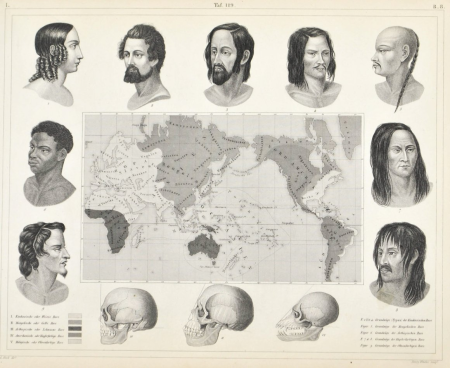
racial type portraits
racial maps
eran laor cartographic collection
german renaissance,humanism
maps by willem and johannes blaeu
novus atlas blaeu
jodocus hondius ii, nova totius terrarum orbis geographica ac hydrographica tabula, 1636
eran laor cartographic collection
jodocus hondius ii, nova totius terrarum orbis geographica ac hydrographica tabula, 1636
eran laor cartographic collection
maps from university of amsterdam special collections
atlas der neederlanden
maps from university of amsterdam special collections
atlas der neederlanden
jodocus hondius ii, nova totius terrarum orbis geographica ac hydrographica tabula, 1636
eran laor cartographic collection
1942 maps of the world
atlantic charter
17th-century maps of andalusia
old maps of the alboran sea
fra mauro map details
cape of good hope
2008 u.s. presidential election maps, democratic primary
2008 iowa election maps
thomas thomasz 1578 map of haarlem
joannes van doetecum (i)
maps of paris from the david rumsey historical map collection
turgot map of paris, david rumsey historical map collection
media from the national library of finland
classicism
old maps of bredevoort
maps by isaak tirion
hendrik van langren map of south asia
1590s maps of armenia
maps made in the 16th century
johannes ruysch
1680s maps of baden-württemberg
old maps of swabia
gemeente atlas van nederland - friesland
19th-century maps of friesland
12001 - 12100 of 38,713
Next page
/ 388


![Gerardi Mercatoris and I. Hondii Atlas or Representation of the Universal World, and of the Parts of It, Made in Tables and Very Ample Descriptions. [t. 2].](https://cdn.creazilla.com/illustrations/10001063637/gerardi-mercatoris-and-i-hondii-atlas-or-representation-of-the-universal-world-and-of-the-parts-of-it-made-in-tables-and-very-ample-descriptions-t-2-sm.webp)


![[Area between Repsoldstrasse and Oberhafen]](https://cdn.creazilla.com/illustrations/10000803566/area-between-repsoldstrasse-and-oberhafen-md.jpg)