Log in
All resources
Create a design
38,713 Free Artworks of Map
eran laor cartographic collection
bibliothèque nationale de france
latin-language maps
coats of arms on maps
frans hogenberg
atlas novus (blaeu)
maps with cartouches
ships on maps
maps of the ottoman empire by mercator-hondius
classicism
maps of paris by louis-joseph mondhare
maps of paris from paris musées
atlas maior, vol 11 (asia) - joan blaeu, 1667 - bl 114.h(star).11
1667 maps
maps from university of amsterdam special collections
atlas der neederlanden
1470s maps of the world
latin-language maps
eran laor cartographic collection
maps by tomas lopez
carte de barbarie, nigritie, guinée par guillaume delisle (1707)
1792 maps of africa
wars of the united kingdom
william wallace
national museum of maps and rare books, bucharest
maps of the lower danube
ptolemy's 10th european map
bologna ptolemy
maps in the british museum
maps facing southeast
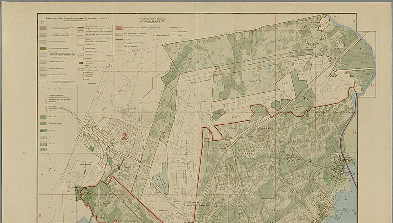
gemeente atlas van nederland - south holland
1860s maps of south holland
maps of paris from bibliothèque nationale de france
maps of paris by jean lattré
italia antiqua (galleria delle carte geografiche)
old maps of italy
1882 in london
port of london
eran laor cartographic collection
french-language maps
maps by john cary
1799 maps
map of the german empire by louis stanislas d'arcy de la rochette
1782 maps of the holy roman empire
old maps of the russian empire
1790s maps of alaska
fra mauro map details
fra mauro map
fra mauro map details
1459 maps
très riches heures du duc de berry
early netherlandish painting
maps in the library of congress
1877 maps of the united states
old maps of cities in texas
1886 drawings
old maps of the arctic
1645
maps of paris from bibliothèque nationale de france
bird's eye view maps of paris
maps by pieter van der keere
maps by abraham ortelius
maps of the palatinate of the rhine
maps by willem and johannes blaeu
maps of the ottoman empire by mercator-hondius
eran laor cartographic collection
19th-century maps of nièvre
1852 maps of france
novus atlas sinensis
old maps of hunan
media from the national library of finland
classicism
old maps of nijmegen
1664 maps
maps by henry wellge
denison, texas
gemeente atlas van nederland - south holland
maps of zoeterwoude
maps from university of amsterdam special collections
atlas der neederlanden
19th-century maps of bohemia
19th-century maps of silesia
maps in the rijksmuseum amsterdam
maps by frederick de wit
maps of the league of nations
1929 maps of the world
17th-century maps of bohemia
1645 maps of austria
old maps of prague
history of karlín
1560s maps of cyprus
ships on maps
18th-century maps of japan
works after jan goeree
old maps of limburg, netherlands
old maps of gelderland
maps in the library of congress
1898 maps of spain
parts of old maps of hamburg
steintor (hamburg)
beautification
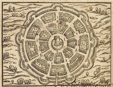
palmanova
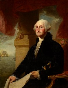
george washington
male
maps by girolamo porro
1572 maps
media from the national library of finland
classicism
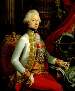
grand duke of tuscany
bookcases in art
eran laor cartographic collection
edward weller
maps by pieter van der keere
maps with cartouches
maps of asia by jean-baptiste bourguignon d'anville
old maps of guangdong
rail transport maps of hamburg
berliner bahnhof (hamburg)
maps of districts of lower saxony
steinfurt in the 1640s
images of places from encyclopædia britannica
maps of paris in the 1910s
maps of paris from paris musées
maps of paris by jean lattré
catalan atlas
mansa musa
maps by willem and johannes blaeu
maps of rotterdam by berckenrode
17th-century maps of schleswig-holstein
nordstrand
henricus hondius ii, nova totius terrarum orbis geographica ac hydrographica tabula, 1630
eran laor cartographic collection
maps of the ottoman empire by mercator-hondius
eran laor cartographic collection
aerial views of amherst, massachusetts
town maps by l. r. burleigh
gemeente atlas van nederland - north holland
19th-century maps of amsterdam
maps by daniel lizars
1831 maps of mexico
1859 maps of hamburg
alster (river)
eran laor cartographic collection
latin-language maps
eran laor cartographic collection
latin-language maps
cartes de franz schrader
1894 maps of france
media from the national library of finland
classicism
maps in the library of congress
1760s maps of china
media from the national library of finland
classicism
maps of waterways in the netherlands
de zegepraalende vecht
japanese art in the metropolitan museum of art
ogata kenzan
1650s maps of the world
age of discovery
maps of paris from bibliothèque nationale de france
maps of paris by louis-joseph mondhare
old maps of the caucasus
guillaume sanson
old maps of groningen (province)
lordship of groningen
maps of the ottoman empire by mercator-hondius
eran laor cartographic collection
maps of waterways in the netherlands
maps of nieuwe merwede
eran laor cartographic collection
maps of diu by braun & hogenberg
maps of braunschweig by braun & hogenberg
eran laor cartographic collection
19th-century maps of the sea of marmara
19th-century maps of the bosphorus
eran laor cartographic collection
latin-language maps
1510s maps of the world
german renaissance
maps in the rijksmuseum amsterdam
published by frans buffa & zonen
maps by richard william seale
maps by malachy postlethwayt
maps of mons city walls (hainaut)
old maps of mons (hainaut)
19th-century maps of vietnam
1810s maps of china
maps of wissembourg by braun & hogenberg
eran laor cartographic collection
history paintings by jan matejko
portraits of nicolaus copernicus
maps by gouverneur k. warren
maps by edwin freyhold
maps by john cary
1799 maps
turgot map of paris, kyoto university library – derivative files
porte saint-antoine
1640s maps of north rhine-westphalia
history of cologne
images in ottův slovník naučný (volume 6)
maps in ottův slovník naučný
1673 in new york city
24 august
maps of wittenberg by braun & hogenberg
eran laor cartographic collection
maps of the ottoman empire by mercator-hondius
eran laor cartographic collection
17th-century maps of the mediterranean sea
copper engravings
12101 - 12200 of 38,713
Next page
/ 388