Log in
All resources
Create a design
38,713 Free Artworks of Map
maps by willem and johannes blaeu
maps from the earth and its inhabitants, vol. vi
bibliothèque nationale de france
classicism
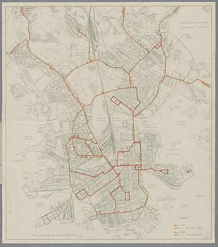
media from the national library of finland
old maps of helsinki
historical aleksanterinkatu project
maps in the national library of finland
national library of finland
coats of arms on maps
bird's-eye views of paris
engravings of paris
maps from the earth and its inhabitants, vol. vi
ferdinand von wrangel
images of places from encyclopædia britannica
maps of paris in the 1910s
zehn karten und ansichten den schlachtfelden des amerikanischen unabhängigkeitskreiges in den staaten pennsylvanien und new york
maps in the library of congress
maps of paris from bibliothèque nationale de france
maps of paris by alexis-hubert jaillot
maps in the rijksmuseum amsterdam
published by frans buffa & zonen
maps of paris from bibliothèque nationale de france
maps of paris by alexis-hubert jaillot
nationaldenkmal kaiser wilhelm i (berlin)
berlin und seine bauten
maps from university of amsterdam special collections
atlas der neederlanden
anne baptiste nivelon
rococo
media from the national library of finland
classicism
gemeente atlas van nederland - north holland
maps of aalsmeer
bird's-eye views of paris
1860 in paris
bernhard von breydenbach
erhard reuwich
maps of weimar by braun & hogenberg
eran laor cartographic collection
maps by willem and johannes blaeu
new amsterdam
maps in the rijksmuseum amsterdam
published by frans buffa & zonen
maps from university of amsterdam special collections
atlas der neederlanden
maps of cambridge by braun & hogenberg
1575 maps of england
old maps of north rhine-westphalia
maps of rietberg
19th-century maps of russia
russia in the 1860s
old maps of the united states
copper engravings
fort victoria (moluccas)
johannes nessel
maps by willem and johannes blaeu
1660s maps of the world
maps by william home lizars
1836 maps of mexico
media from the national library of finland
classicism
old maps of the united states
sanson maps of north america
maps of venlo by willem and johannes blaeu
city wall of venlo
jean étienne guettard
philippe buache
media from the national library of finland
classicism
1650s maps of taiwan
1654 maps
maps by william home lizars
1836 maps of mexico
maps of paris from bibliothèque nationale de france
maps of paris by alexis-hubert jaillot
18th-century maps of greenland
old maps of the arctic
bathymetric maps of the indian ocean
topographic maps of asia
jean étienne guettard
philippe buache
churches in rome in art
renaissance
carte de la mer mediterranée (1764) by roux
eran laor cartographic collection
1830s maps of switzerland
1834 maps of europe
coats of arms of the kingdom of navarre
pales of aragon in heraldry
maps by willem and johannes blaeu
old maps of overijssel
magni ducatus lithuaniae
ros' river
old maps of the dutch east india company - malaysia
maps of the dutch east india company - indonesia
atlas van der hagen (volume 2)
1680s maps of the netherlands
maps from university of amsterdam special collections
atlas der neederlanden
maps of lichtenvoorde
house of bronckhorst
old maps of cities in texas
maps of paris, texas
atlas maior, vol 11 (asia) - joan blaeu, 1667 - bl 114.h(star).11
1667 maps
maps of edinburgh by braun & hogenberg
16th-century maps of scotland
maps by willem and johannes blaeu
copper engravings
media from the national library of finland
classicism
maps from traité de la police, bibliothèque nationale de france
fourth map of paris from traité de la police
drawings in the groeningemuseum
maps by pieter pourbus
a plan of the operations of the king's army under the command of general sr. william howe, k.b. in new york and east new jersey, against the american forces commanded by general washington, from the 12th. of october, to the 28th. of november 1776
old maps of new york (state) from the norman b. leventhal map center
maps from the portail des bibliothèques spécialisées de la ville de paris
maps from the bibliothèque historique de la ville de paris
maps by alain manesson-mallet
description de l'universe
curt teich postcard archives
postcards of muncie, indiana
maps of lake chad
gustav nachtigal
old maps of the bering strait
18th-century maps of siberia
st andrew's church (roman catholic, manhattan)
sanborn maps of manhattan published in 1905
1780s maps of florida
maps of florida
17th-century maps of the strait of magellan
1635 maps
media from the national library of finland
classicism
16th-century images of algiers
maps of ottoman algeria
beschreibung der städt der welt - braun & hogenberg - btv1b52512111k
maps of munich by braun & hogenberg
old maps of livonia
old maps of latvia
old county maps of hampshire
old county maps of berkshire
maps in the library of congress
selma, alabama
ferdinand von wrangel
peter anjou
17th-century maps of the moluccas
latin-language maps
ferdinand von wrangel
peter anjou
magni ducatus lithuaniae
dnieper in ukraine
eran laor cartographic collection
latin-language maps
16th-century maps of sri lanka
ptolemy's 12th asian map
map collection of leibniz-institut für länderkunde
1603 in art
jacques le moyne de morgues
1591 maps
maps by willem and johannes blaeu
coats of arms on maps
old maps of the chesapeake bay
sir walter raleigh
copper engravings
old maps of goes
atlas maior, vol 1 (northern europe, norway, and denmark) - joan blaeu, 1667 - bl 114.h(star).1
17th-century double hemisphere world maps
1600s maps of mecklenburg-vorpommern
maps of rügen by eilhard lubinus
maps by pieter van der keere
willem barentsz
ptolemy's 2nd asian map
maps by girolamo porro
16th-century maps of ireland
maps by pieter van der keere
curt teich postcard archives, curt teich & company
map postcards
pulaski, new york
1885 engravings
1886 in waco, texas
1886 maps of texas
old maps of cities in texas
maps of fort worth, texas
magni ducatus lithuaniae
1613 maps of europe
old maps of the county of ravensberg
duchy of cleves
maps by richard william seale
1750 maps of africa
1730s maps of the netherlands
1730 maps
1780s maps of the philippines
old maps of palau
18th-century maps of the sea of marmara
18th-century maps of the dardanelles
maps in the library of congress
1884 maps of new york (state)
1754 maps of the bahamas
1754 maps of florida
maps from the earth and its inhabitants, vol. viii
maps of turkestan
maps from the earth and its inhabitants, vol. viii
maps of turkestan
maps from the earth and its inhabitants, vol. vii
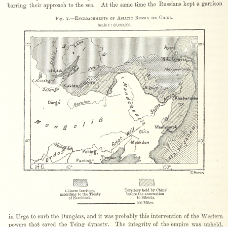
russian conquest of siberia
engravings
1637
11901 - 12000 of 38,713
Next page
/ 388


![[Ten maps and views of the battlefields of the American Revolutionary War in the states of Pennsylvania and New York], 1777](https://cdn.creazilla.com/illustrations/10001017179/ten-maps-and-views-of-the-battlefields-of-the-american-revolutionary-war-in-the-states-of-pennsylvania-and-new-york-1777-md.jpg)