Log in
All resources
Create a design
38,713 Free Artworks of Map
turgot map of paris, norman b. leventhal map center
norman b. leventhal map center
turgot map of paris
france
featured and good content
maps with figures
novus atlas sinensis
joan blaeu
maps with cartouches
copper engraving print
old maps of the american revolution
1777 maps of new york (state)
maps from the earth and its inhabitants, vol. viii
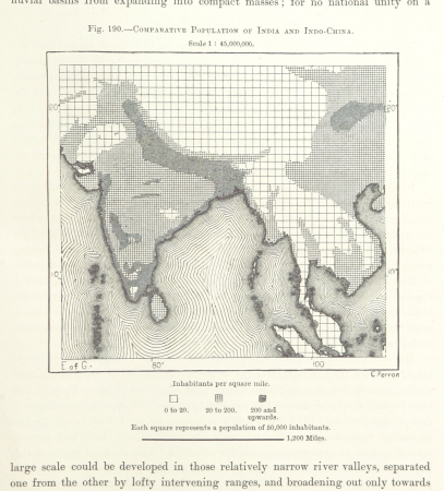
population density maps of india
1895 maps of new york (state)
old maps of albany, new york
maps from the earth and its inhabitants, vol. vi
tian shan
maps from the earth and its inhabitants, vol. vi
tian shan
old maps of the duchy of jülich
maps of the duchy of berg
old maps of bouvet island
bouvet island
danubius pannonico-mysicus
1720s maps of transylvania
john rocque's 1746 map of london
history of london
17th-century maps of the baltic sea
17th-century maps of scandinavia
atlas maior, vol 11 (asia) - joan blaeu, 1667 - bl 114.h(star).11
1667 maps
old submaps of paris 17e arrondissement
plan de roussel - derivative files
1660s maps of belgium
old maps of bruges
turgot map of paris, norman b. leventhal map center
sheet 19 of the turgot map of paris
edward wright (mathematician)
maps by jodocus hondius
maps by cornelis anthonisz.
1560 maps of europe
maps by john tallis
maps by john rapkin
old maps of rügen
prussian columns
maps by giacomo gastaldi
maps by gerard de jode
15th-century maps of the iberian peninsula
15th-century maps of africa
maps in the library of congress
novus atlas sinensis
1850s maps of the americas
maps by john tallis
portrait paintings of men by george romney
rococo
maps in the library of congress
1877 in ohio
topographia franconiae (merian)
baroque
novus atlas sinensis
maps of yangzhou
charles frederick cheffins
1841 maps of texas
ethnographic maps of austria-hungary
1890s maps of austria-hungary
french paintings in the musée des beaux-arts de strasbourg
ermine (clothing) in art
fort zeelandia, taiwan in art
siege of fort zeelandia
admiralty charts region b: england wales ireland english channel southern north sea
admiralty charts 1801-2000
maps by john cary
1799 maps
details of old maps of the world showing "aquita" in japan
johannes baptista vrints
hydrographic and oceanographic department, japan coast guard
old japanese nautical charts
portrait paintings in the crystal bridges museum of american art
male
18th-century portrait paintings in germany
18th-century portrait paintings with dogs
1st baronet
london
history paintings by jan matejko
portraits of nicolaus copernicus
definitive stamps of australia
1929 stamps of australia
chao meng-fu (crater)
cervantes (crater)
turgot map of paris, norman b. leventhal map center
sheet 15 of the turgot map of paris
turgot map of paris, norman b. leventhal map center
sheet 6 of the turgot map of paris
turgot map of paris, norman b. leventhal map center
sheet 14 of the turgot map of paris
turgot map of paris, norman b. leventhal map center
sheet 16 of the turgot map of paris
willem schouten
willem blaeu
turgot map of paris, norman b. leventhal map center
sheet 2 of the turgot map of paris
turgot map of paris, norman b. leventhal map center
sheet 9 of the turgot map of paris
turgot map of paris, norman b. leventhal map center
sheet 5 of the turgot map of paris
turgot map of paris, norman b. leventhal map center
sheet 1 of the turgot map of paris
turgot map of paris, norman b. leventhal map center
sheet 10 of the turgot map of paris
turgot map of paris, norman b. leventhal map center
sheet 4 of the turgot map of paris
turgot map of paris, norman b. leventhal map center
sheet 11 of the turgot map of paris
turgot map of paris, norman b. leventhal map center
sheet 13 of the turgot map of paris
turgot map of paris, norman b. leventhal map center
sheet 7 of the turgot map of paris
turgot map of paris, norman b. leventhal map center
sheet 20 of the turgot map of paris
turgot map of paris, norman b. leventhal map center
sheet 12 of the turgot map of paris
turgot map of paris, norman b. leventhal map center
sheet 17 of the turgot map of paris
turgot map of paris, norman b. leventhal map center
sheet 3 of the turgot map of paris
1855 maps of the russian empire
1850s maps of crimea
17th-century maps of asia
maps from gallica
german-language maps from ios map collection
18th-century maps of the black sea
atlas van der hagen (volume 4)
atlas van der hagen
maps by daniel lizars
1830s maps of belize
maps of french louisiana
old maps of louisiana
johann friedrich leberecht reinhold
18th-century children
maps by willem and johannes blaeu
old maps of middelburg, zeeland
16th-century maps of the adriatic sea
willem barentsz
1810s maps of the near east
maps by john cary
1774 maps of asia
baroque painting
1650s maps of china
1655 maps of asia
maps from the earth and its inhabitants, vol. vi
tian shan
fra mauro map details
15th-century ships
maps from the mechanical curator collection available to georeference
maps from the mechanical curator collection
maps of paris from bibliothèque nationale de france
old maps of the paris metro
maps of crimean war
peredvizhniki
atlas maior, vol 11 (asia) - joan blaeu, 1667 - bl 114.h(star).11
1667 maps
fort zeelandia, taiwan in art
siege of fort zeelandia
maps of lunae palus quadrangle
maps of arcadia quadrangle
danubius pannonico-mysicus
1726 books
maps of metz city walls
old maps of metz
17th-century maps of the black sea
maps by willem and johannes blaeu
history of the palace of westminster
maps by john rocque
17th-century maps of lower saxony
atlas novus (blaeu)
fort zeelandia, taiwan in art
siege of fort zeelandia
maps in the biblioteca nacional de españa
spanish-language maps
atlas maior, vol 11 (asia) - joan blaeu, 1667 - bl 114.h(star).11
1667 maps
1590s maps of brazil
animals on maps
old maps of arkansas in the american civil war
julius bien
maps of argyre quadrangle
mars topography
1810s maps of the near east
maps by john cary
maps in the library of congress
1861 maps of the united states
maps in civica raccolta delle stampe achille bertarelli (milan)
mdlxxiii (numeral)
russian empire in thomas kitchen's general atlas (1773)
general atlas (1773)
maps of massachusetts from the norman b. leventhal map center
maps of becket, massachusetts
16th-century maps of the persian gulf
16th-century maps of the red sea
1890s maps of the united states
maps of the thousand islands
john rocque's 1746 map of london
kensington gardens in art
1370s maps of egypt
catalan atlas
atlas van der hagen
mount wutai
toonneel der steden van de vereenighde nederlanden, met hare beschrijvingen
maps in utrecht university library
11601 - 11700 of 38,713
Next page
/ 388