Log in
All resources
Create a design
38,713 Free Artworks of Map
africa in the 1890s
maps of africa
maps from the earth and its inhabitants, vol. xii
bibliothèque nationale de france
maps from the earth and its inhabitants, vol. xiii
maps from the earth and its inhabitants, vol. xi
eran laor cartographic collection
maps from university of amsterdam special collections
atlas der neederlanden
copperplate print
old maps of hainaut (province)
1590s maps of belgium
old maps of leiden
baroque
17th-century maps of switzerland
maps by pieter van der keere
maps of the byzantine levant
1650s maps showing history
guillaume-nicolas delahaye
jacques martin
print room of the university of antwerp
18th-century maps of antwerp
maps from the earth and its inhabitants, vol. viii
maps of india
maps from the earth and its inhabitants, vol. xi
maps of benghazi
maps from the earth and its inhabitants, vol. v
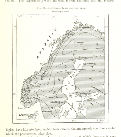
maps of scandinavia
maps from the earth and its inhabitants, vol. xvii
maps of minneapolis
maps from the earth and its inhabitants, vol. v
maps of scandinavia
maps from the earth and its inhabitants, vol. ix
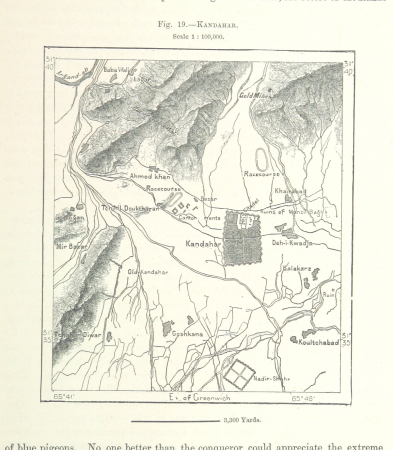
maps of kandahar
maps from the earth and its inhabitants, vol. viii
maps of india
medieval
maps
carte de partie de lithuanie (north belarus, polazk) by nicolas sanson
cartouches by sanson family
topographischer atlas der schweiz
maps of glaciers of switzerland
maps from the earth and its inhabitants, vol. xiii
africa in the 1890s
maps from the earth and its inhabitants, vol. xii
africa in the 1890s
maps from the earth and its inhabitants, vol. xi
africa in the 1890s
maps from the earth and its inhabitants, vol. xi
africa in the 1890s
maps from the earth and its inhabitants, vol. xii
africa in the 1890s
maps from the earth and its inhabitants, vol. xii
africa in the 1890s
maps from the earth and its inhabitants, vol. xii
africa in the 1890s
maps from the earth and its inhabitants, vol. xii
africa in the 1890s
maps from the earth and its inhabitants, vol. xiii
maps of africa
maps from the earth and its inhabitants, vol. xii
africa in the 1890s
maps from the earth and its inhabitants, vol. xii
africa in the 1890s
maps from the earth and its inhabitants, vol. xiii
africa in the 1890s
maps of ghent by armand heins
old maps of ghent
maps from the earth and its inhabitants, vol. xiii
maps of africa
maps from the earth and its inhabitants, vol. xii
africa in the 1890s
maps by willem and johannes blaeu
maps of the wadden sea
maps from the earth and its inhabitants, vol. xii
africa in the 1890s
maps from the earth and its inhabitants, vol. xii
africa in the 1890s
description de l'universe
maps of socotra
maps by jakob van der schley
old maps of southeast asia
eran laor cartographic collection
johann ulrich krauß
print room of the university of antwerp
kaarten van vlaanderen (prentenkabinet)
perris & browne maps of manhattan published in 1857
neoclassicism
voyages and travels to india, ceylon, the red sea, abyssinia, and egypt, vol. 2
henry cooper (engraver)
charles william meredith van de velde
eran laor cartographic collection
1730s maps of the americas
1730s maps
atlas of the great elector
archipelagus orientalis
maps of the firth of forth
old maps of fife
le neptune francois
charles pène 8th
maps by willem and johannes blaeu
robert gordon of straloch
eran laor cartographic collection
tranquillo mollo
1782 maps of the caribbean
maps by juan lopez
sanson maps of the netherlands
1700s maps of the netherlands
eran laor cartographic collection
tranquillo mollo
siberia and the exile system (1891)
19th-century maps of siberia
siberia and the exile system (1891)
19th-century maps of siberia
maps by pieter mortier
maps from gallica
eran laor cartographic collection
william hughes (geographer)
eran laor cartographic collection
joris hoefnagel
a new map of the island of tobago... - by tho.s kitchin... - btv1b53121990k
maps by thomas kitchin
maps of saint paul's journeys
maps by pieter van der keere
16th-century maps of the western mediterranean
lucas janszoon waghenaer
maps from university of amsterdam special collections
atlas der neederlanden
maps from university of amsterdam special collections
atlas der neederlanden
maps from university of amsterdam special collections
atlas der neederlanden
maps from university of amsterdam special collections
atlas der neederlanden
maps from university of amsterdam special collections
atlas der neederlanden
maps from university of amsterdam special collections
atlas der neederlanden
maps from the earth and its inhabitants, vol. ix
maps of herat
maps from the earth and its inhabitants, vol. v
maps of scandinavia
maps from the earth and its inhabitants, vol. vii
maps of lhasa
maps from the earth and its inhabitants, vol. xiv
maps of australia
maps from the earth and its inhabitants, vol. xii
africa in the 1890s
collections of stadsarchief delft
old maps of delft
old maps of the moon
tobias mayer
eran laor cartographic collection
nicolas langlois
maps from the earth and its inhabitants, vol. xiii
maps of africa
maps from the earth and its inhabitants, vol. xiii
africa in the 1890s
maps from the earth and its inhabitants, vol. xiii
maps of africa
maps from the earth and its inhabitants, vol. xiii
africa in the 1890s
maps from the earth and its inhabitants, vol. xiii
africa in the 1890s
maps from the earth and its inhabitants, vol. xiii
maps of africa
details of old maps of india
atlas minor
portolan charts by willem and johannes blaeu
old maps of friesland
maps from the earth and its inhabitants, vol. xii
africa in the 1890s
maps from the earth and its inhabitants, vol. xiii
africa in the 1890s
maps from the earth and its inhabitants, vol. xi
africa in the 1890s
maps from the earth and its inhabitants, vol. xii
africa in the 1890s
maps from the earth and its inhabitants, vol. xii
africa in the 1890s
maps from the earth and its inhabitants, vol. xi
africa in the 1890s
africa in the 1890s
maps of africa
maps from the earth and its inhabitants, vol. xi
africa in the 1890s
maps from the earth and its inhabitants, vol. xii
africa in the 1890s
maps from the earth and its inhabitants, vol. xiii
maps of africa
maps from the earth and its inhabitants, vol. xiii
africa in the 1890s
maps from the earth and its inhabitants, vol. xi
africa in the 1890s
maps from the earth and its inhabitants, vol. xi
africa in the 1890s
maps from the earth and its inhabitants, vol. xi
africa in the 1890s
maps from the earth and its inhabitants, vol. xii
africa in the 1890s
maps from the earth and its inhabitants, vol. xii
africa in the 1890s
maps of catania by braun & hogenberg
1592 maps of italy
maps from the earth and its inhabitants, vol. xi
africa in the 1890s
maps from the earth and its inhabitants, vol. xii
africa in the 1890s
maps from the earth and its inhabitants, vol. xii
africa in the 1890s
18001 - 18100 of 38,713
Next page
/ 388


![Map of the Slaperdijk stretching from the Stichtse mountains to the height of Gelderland / ... Justus van Broeckhuysen ... measured and charted accordingly ... in September 1705; [engraved by Caspar Specht], Caspar Specht, 1705](https://cdn.creazilla.com/illustrations/10000611407/map-of-the-slaperdijk-stretching-from-the-stichtse-mountains-to-the-height-of-gelderland-justus-van-broeckhuysen-measured-and-charted-accordingly-in-september-1705-engraved-by-caspar-specht-caspar-specht-1705-md.jpg)
![Map of the polders of Out and Nieuw Herckingen / Heyman van Dyck fecit; I. Shutters fecit cum aqua forti; A. Steyaart invented; I. Stemmer's sculpsit, Romeyn de Hooghe, [1701]](https://cdn.creazilla.com/illustrations/10000842157/map-of-the-polders-of-out-and-nieuw-herckingen-heyman-van-dyck-fecit-i-shutters-fecit-cum-aqua-forti-a-steyaart-invented-i-stemmer-s-sculpsit-romeyn-de-hooghe-1701-md.jpg)
![Map of the Slaperdijk stretching from the Stichtse mountains to the height of Gelderland / ... Justus van Broeckhuysen ... measured and charted accordingly ... in September 1705; [engraved by Caspar Specht], Caspar Specht, 1705](https://cdn.creazilla.com/illustrations/10001105269/map-of-the-slaperdijk-stretching-from-the-stichtse-mountains-to-the-height-of-gelderland-justus-van-broeckhuysen-measured-and-charted-accordingly-in-september-1705-engraved-by-caspar-specht-caspar-specht-1705-md.jpg)
![Map of the Slaperdijk stretching from the Stichtse mountains to the height of Gelderland / ... Justus van Broeckhuysen ... measured and charted accordingly ... in September 1705; [engraved by Caspar Specht], Caspar Specht, 1705](https://cdn.creazilla.com/illustrations/10001202757/map-of-the-slaperdijk-stretching-from-the-stichtse-mountains-to-the-height-of-gelderland-justus-van-broeckhuysen-measured-and-charted-accordingly-in-september-1705-engraved-by-caspar-specht-caspar-specht-1705-md.jpg)
![Map of the Slaperdijk stretching from the Stichtse mountains to the height of Gelderland / ... Justus van Broeckhuysen ... measured and charted accordingly ... in September 1705; [engraved by Caspar Specht], Caspar Specht, 1705](https://cdn.creazilla.com/illustrations/10001411130/map-of-the-slaperdijk-stretching-from-the-stichtse-mountains-to-the-height-of-gelderland-justus-van-broeckhuysen-measured-and-charted-accordingly-in-september-1705-engraved-by-caspar-specht-caspar-specht-1705-md.jpg)
![Map of the Slaperdijk stretching from the Stichtse mountains to the height of Gelderland / ... Justus van Broeckhuysen ... measured and charted accordingly ... in September 1705; [engraved by Caspar Specht], Caspar Specht, 1705](https://cdn.creazilla.com/illustrations/10001438819/map-of-the-slaperdijk-stretching-from-the-stichtse-mountains-to-the-height-of-gelderland-justus-van-broeckhuysen-measured-and-charted-accordingly-in-september-1705-engraved-by-caspar-specht-caspar-specht-1705-md.jpg)


