Log in
All resources
Create a design
38,713 Free Artworks of Map
eran laor cartographic collection
joan blaeu
bibliothèque nationale de france
ateliers bmb mercator
british library
copper engraving print
latin-language maps
1667 maps
english-language maps
description de l'universe
maps by willem and johannes blaeu
ducatus holsatiæ nova tabula
1600 world map by girolamo porro
leonardo cernoti
1600 world map by girolamo porro
leonardo cernoti
maps of the british isles by gerardus mercator
ateliers bmb mercator
maps of north england by gerardus mercator
ateliers bmb mercator
maps of europe by mercator-hondius
ateliers bmb mercator
1760s maps of the americas
1760 maps
atlas sive cosmographicae (gerardus mercator, 1596)
gerardus mercator
truscott map of st-petersburg 1753
german quarter
maps of metz city walls
old maps of metz
eran laor cartographic collection
giovanni maria cassini
jodocus hondius ii, nova totius terrarum orbis geographica ac hydrographica tabula, 1636
maps in the library of congress
maps of the dutch east india company - sri lanka
1787
renaissance
appalachia
map of the circle of austria by sanson
1700s maps of austria
maps in the library of congress
old maps of latin america
maps of wissembourg by braun & hogenberg
maps of rouffach by braun & hogenberg
description de l'universe
alain manesson mallet
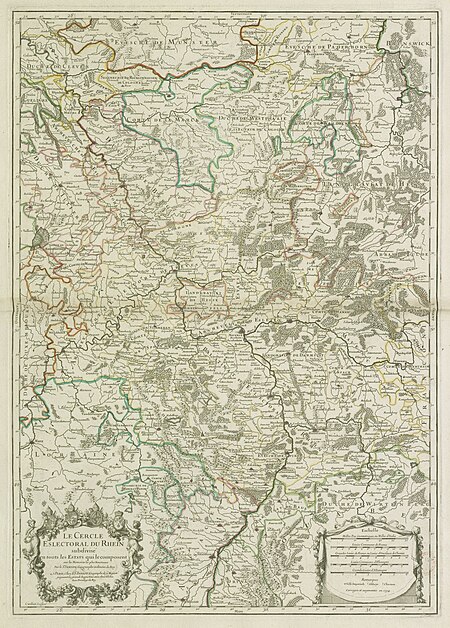
map of the circle of the rhineland by sanson
1730s maps of rhineland-palatinate
maps from the earth and its inhabitants, vol. xii
africa in the 1890s
maps from the earth and its inhabitants, vol. xiii
africa in the 1890s
historical images of église saint-nicolas-du-chardonnet
map of paris by braun & hogenberg - derivative files
atlas maior, vol 4 (netherlands) - joan blaeu, 1667 - bl 114.h(star).4
1667 maps
atlas maior, vol 11 (asia) - joan blaeu, 1667 - bl 114.h(star).11
1667 maps
description de l'universe
1685 maps of europe
biblioteca di storia e cultura del piemonte "giuseppe grosso"
media from giuseppe grosso library
media from accademia delle scienze di torino
1573 maps of italy
eran laor cartographic collection
german renaissance,humanism
eran laor cartographic collection
romeyn de hooghe
eran laor cartographic collection
romanticism
eran laor cartographic collection
joan blaeu
eran laor cartographic collection
german renaissance,humanism
eran laor cartographic collection
emanuel bowen
eran laor cartographic collection
cornelis de bruyn
description de l'universe
alain manesson mallet
map of paris by jouvin de rochefort (boutier 112)
maps of paris by françois de la pointe
maps by willem and johannes blaeu
maps of woerden
historical maps of crema
maps by pieter mortier
maps from the earth and its inhabitants, vol. xiii
africa in the 1890s
maps of venice by braun & hogenberg
17th-century maps of venice
maps from the earth and its inhabitants, vol. xiii
africa in the 1890s
details of old maps
la virginea pars
details of old maps
michael burghers
description de l'universe
1710s maps of indonesia
history of greenwich (district of london)
john rocque 1746 london map (a1-h3)
eran laor cartographic collection
william hole (engraver)
eran laor cartographic collection
cornelis de bruyn
eran laor cartographic collection
gerard de jode
eran laor cartographic collection
cornelis de bruyn
eran laor cartographic collection
cornelis de bruyn
maps of utrecht (city) city walls
old maps of utrecht (city)
eran laor cartographic collection
german renaissance,humanism
eran laor cartographic collection
martin engelbrecht
eran laor cartographic collection
joan blaeu
breda, netherlands in the 17th century
old maps of north brabant
eran laor cartographic collection
william hole (engraver)
maps of asia by mercator-hondius
ateliers bmb mercator
maps of cornwall and south wales by gerardus mercator
ateliers bmb mercator
maps of africa by mercator-hondius
ateliers bmb mercator
maps by willem and johannes blaeu
17th-century maps of iceland
maps from the earth and its inhabitants, vol. x
20th-century double hemisphere world maps
map of ghent by abraham casteleyn
abraham casteleyn
maps of bamberg by braun & hogenberg
st. martin (bamberg)
maps of the americas by mercator-hondius
ateliers bmb mercator
maps of paris from the stanford libraries
maps of paris by braun & hogenberg
maps of constantine (algeria)
cartes de franz schrader
amérique méridionale (1748, d'anville)
rococo
1880s maps of taiwan
1889 in taiwan
maps of the history of czechia
engravings by wolfgang kilian
maps in the stadsarchief amsterdam
die grund-regeln der bau-kunst
avignon in the 17th century
atlas van loon
1870s maps of the caucasus
g. h. swanston
maps from university of amsterdam special collections
atlas der neederlanden
considérations géographiques et physiques sur les nouvelles découvertes au nord de la grande mer
eso island
1870s maps of the caucasus
g. h. swanston
old maps of plymouth and devonport
16th-century maps of england
considérations géographiques et physiques sur les nouvelles découvertes au nord de la grande mer
isla de los estados
considérations géographiques et physiques sur les nouvelles découvertes au nord de la grande mer
eso island
geological maps of pennsylvania
1885 maps of philadelphia
atlas maior, vol 10 (spain and africa) - joan blaeu, 1667 - bl 114.h(star).10
1667 maps
geological maps of pennsylvania
1885 maps of philadelphia
atlas maior, vol 10 (spain and africa) - joan blaeu, 1667 - bl 114.h(star).10
1667 maps
kaart van suriname naar opmetingen gedaan in de jaren 1860-1879
albina, suriname
maps from university of amsterdam special collections
atlas der neederlanden
maps from university of amsterdam special collections
atlas der neederlanden
nypl the miriam and ira d. wallach division of art, prints and photographs: print collection
impressionism
malebné cesty po praze (1884)
old maps of czechia
le neptune francois
1700 maps of cuba
old maps of the strait of gibraltar
a school geography (1898) by bird
atlas maior, vol 9 (italy) - joan blaeu, 1667 - bl 114.h(star).9
1667 maps of italy
atlas maior, vol 6 (scotland and ireland) - joan blaeu, 1667 - bl 114.h(star).6
1667 maps
media from regionaal archief alkmaar
maps of wieringerwaard
media from regionaal archief alkmaar
zijpe
gemeente atlas van nederland - north holland
old maps of hoorn, north holland
bird's eye view maps of connecticut
jewett city, connecticut
flemish prints in the british museum
coenraed lauwers
maps in the national library of scotland
blaeu atlas of scotland 1654
mercator 1587 world map
maps by jodocus hondius
media contributed by university of illinois urbana-champaign university library
carte du mexique et de la floride by guillaume delisle (1703)
hendrik van langren map of south asia
1595 maps of asia
17801 - 17900 of 38,713
Next page
/ 388


![The High Council of Delflant / according to order by Kruikius; [mapped by N. and J. Kruikius]; L. van Anse, T. Doesburch, Jac. et Joan. Deur, and P. Ruyter sculpt, 1712](https://cdn.creazilla.com/illustrations/10001543120/the-high-council-of-delflant-according-to-order-by-kruikius-mapped-by-n-and-j-kruikius-l-van-anse-t-doesburch-jac-et-joan-deur-and-p-ruyter-sculpt-1712-sm.webp)


