Log in
All resources
Create a design
38,713 Free Artworks of Map
maps from university of amsterdam special collections
atlas der neederlanden
copperplate print
special collections of the university of amsterdam
africa in the 1890s
maps of africa
eran laor cartographic collection
ateliers bmb mercator
maps from the earth and its inhabitants, vol. x
atlas der neederlanden deel ii: holland 1. zuid-holland
final report of the northwest territory celebration commission
1938 maps
maps from university of amsterdam special collections
atlas der neederlanden
eran laor cartographic collection
tranquillo mollo
eran laor cartographic collection
jaspar isaac
eran laor cartographic collection
joseph roux
the hague in the 1720s
old maps of the hague
cartouches by willem and johannes blaeu
maps from the earth and its inhabitants, vol. x
19th-century maps of africa
maps from the earth and its inhabitants, vol. x
19th-century maps of africa
maps of bamberg by braun & hogenberg
torschuster
maps from the earth and its inhabitants, vol. x
19th-century maps of africa
maps of bamberg by braun & hogenberg
st. gangolf (bamberg)
turgot map of paris, david rumsey historical map collection – derivative files
historical images of the hôpital de la pitié-salpêtrière
everett d. graff collection of western americana
maps of the united states
maps from university of amsterdam special collections
atlas der neederlanden
maps from university of amsterdam special collections
atlas der neederlanden
maps from university of amsterdam special collections
atlas der neederlanden
maps from university of amsterdam special collections
atlas der neederlanden
maps from university of amsterdam special collections
atlas der neederlanden
german renaissance
stabius world map
maps of north ireland by gerardus mercator
ateliers bmb mercator
maps of south ireland by gerardus mercator
ateliers bmb mercator
maps of asia by mercator-hondius
ateliers bmb mercator
maps from the earth and its inhabitants, vol. x
19th-century maps of africa
the adventure of the priory school
illustrations by c. r. macauley
maps from the earth and its inhabitants, vol. x
19th-century maps of africa
maps by willem and johannes blaeu
ducatus holsatiæ nova tabula
select views in india, drawn on the spot, in the years 1780, 1781, 1782, and 1783
british library asia, pacific and africa collections
maps from the earth and its inhabitants, vol. xii
africa in the 1890s
maps from the earth and its inhabitants, vol. xii
africa in the 1890s
maps from the earth and its inhabitants, vol. xii
africa in the 1890s
1600s maps of lower saxony
maps by abraham ortelius
17th-century maps of herefordshire
1646 maps
maps of scotland by gerardus mercator
ateliers bmb mercator
maps of the americas by michael mercator
ateliers bmb mercator
maps of ulster by gerardus mercator
ateliers bmb mercator
maps of idrone by gerardus mercator
ateliers bmb mercator
eran laor cartographic collection
nicolas langlois
maps from the earth and its inhabitants, vol. xii
africa in the 1890s
maps from the earth and its inhabitants, vol. xiii
africa in the 1890s
maps from the earth and its inhabitants, vol. xii
africa in the 1890s
maps of freiberg by braun & hogenberg
eran laor cartographic collection
maps from the earth and its inhabitants, vol. xiii
africa in the 1890s
maps from the earth and its inhabitants, vol. xiii
africa in the 1890s
1720s maps of slovenia
1720 maps
maps from the earth and its inhabitants, vol. xiii
africa in the 1890s
maps of cologne by braun & hogenberg
eran laor cartographic collection
17th-century maps of maastricht
siege of maastricht (1632)
maps of utrecht (city) city walls
old maps of utrecht (city)
eran laor cartographic collection
baroque
media from regionaal archief alkmaar
sint pancras
maps of cagliari by braun & hogenberg
maps in cosmographia (münster)
old maps of poland
duchnice
hamburgische elbkarte von melchior lorichs
parts of old maps of hamburg
maps by willem and johannes blaeu
1635 maps
van langren map of southeast asia
1599 maps of asia
maps of paris from bibliothèque nationale de france
map of paris by claes jansz. visscher
parts of old maps of bremen
baroque
old maps of north rhine-westphalia
maps of betuwe
maps from university of amsterdam special collections
atlas der neederlanden
maps from university of amsterdam special collections
atlas der neederlanden
maps from university of amsterdam special collections
atlas der neederlanden
maps from university of amsterdam special collections
atlas der neederlanden
turgot map of paris, norman b. leventhal map center – derivative files
rue de braque on maps
russian geographical society
stamps of russia, 2020
description de l'universe
1680s maps of the world
maps from the earth and its inhabitants, vol. xvii
history of florida
maps from university of amsterdam special collections
atlas der neederlanden
eran laor cartographic collection
carolus allard
maps from géographie illustrée de la france et de ses colonies
19th-century maps of calvados
maps from university of amsterdam special collections
atlas der neederlanden
maps from university of amsterdam special collections
atlas der neederlanden
maps from university of amsterdam special collections
atlas der neederlanden
maps from university of amsterdam special collections
atlas der neederlanden
maps from university of amsterdam special collections
atlas der neederlanden
maps from university of amsterdam special collections
atlas der neederlanden
the loyal west in the times of the rebellion (ohio)
maps of the cuyahoga river
gemeente atlas van nederland - north holland
maps of broek in waterland
maps by isaak tirion
1753 maps
maps of the french invasion of russia
emery walker
atlas vingboons
1665
maps in the library of congress
1877 maps of the united states
maps of bourgogne (duchy) by gerardus mercator
1630s maps of france
maps of milan by braun & hogenberg
baroque
plan de roussel - derivative files
maps of montrouge
media from regionaal archief alkmaar
egmond-binnen
maps from the earth and its inhabitants, vol. iv
19th-century double hemisphere world maps
maps of rivers of south sudan
sobat river
maps from the earth and its inhabitants, vol. xi
maps indicating exploration
maps from the earth and its inhabitants, vol. vii
19th-century maps of korea
maps from the earth and its inhabitants, vol. iv
portskewett
lawrence h. slaughter collection of english maps, charts, globes, books and atlases
de nieuwe en onbekende weereld
maps from the earth and its inhabitants, vol. iv
cirencester
novi belgii, atlas maior
maps of new england
maps from the earth and its inhabitants, vol. xiii
old maps of luanda
maps from the earth and its inhabitants, vol. iv
eddystone rocks, devon
maps from the earth and its inhabitants, vol. vi
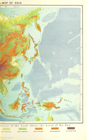
topographic maps of asia
maps from the earth and its inhabitants, vol. vii
linguistic maps of chinese languages
maps from the earth and its inhabitants, vol. xi
roads in tunisia
maps from the earth and its inhabitants, vol. iii
maps of the sava watercourse system
17401 - 17500 of 38,713
Next page
/ 388


![New map of the dike district of the eastern bailiwick of West Friesland, called Medenblick and the Vier Noorder Coggen / Pieter Straat inventor; made in copper by Hendrik de Leth, [1732]](https://cdn.creazilla.com/illustrations/10000394364/new-map-of-the-dike-district-of-the-eastern-bailiwick-of-west-friesland-called-medenblick-and-the-vier-noorder-coggen-pieter-straat-inventor-made-in-copper-by-hendrik-de-leth-1732-md.jpg)
![Carte des Isles Philippines, Celebes et Moluccas = Map of the Philippines, Celebes, and Moluccas Islands / J. v. Schley direct, Jakob van der Schley, [1747]](https://cdn.creazilla.com/illustrations/10001211531/carte-des-isles-philippines-celebes-et-moluccas-map-of-the-philippines-celebes-and-moluccas-islands-j-v-schley-direct-jakob-van-der-schley-1747-sm.webp)
![Map of Siam, Tonkin, Pegu, Ava, Arakan - J.V.S. Cartography, Jakob van der Schley, [1773]](https://cdn.creazilla.com/illustrations/10001321492/map-of-siam-tonkin-pegu-ava-arakan-j-v-s-cartography-jakob-van-der-schley-1773-sm.jpg)
![Map of the old new lands in West Voorn / I. Luiken fecit cum aqua forti; A. Steyaart invented; I. Stemmer's sculpsit, Romeyn de Hooghe, [1701]](https://cdn.creazilla.com/illustrations/10000299995/map-of-the-old-new-lands-in-west-voorn-i-luiken-fecit-cum-aqua-forti-a-steyaart-invented-i-stemmers-sculpsit-romeyn-de-hooghe-1701-md.jpg)
![New map of the Kingdom of Bengal / J.V. Schley direct, Jakob van der Schley, [1773]](https://cdn.creazilla.com/illustrations/10001347432/new-map-of-the-kingdom-of-bengal-jv-schley-direct-jakob-van-der-schley-1773-md.jpg)


![Caarte van Ste. Anna Polder ende ’t Schape Gors / H. vander Dyck fecit; A. Steyaart invenit; I. Stemmers sculpsit; I. Luiken fecit cum aqua forti, Romeyn de Hooghe, [1701]](https://cdn.creazilla.com/illustrations/10000526879/caarte-van-ste-anna-polder-ende-t-schape-gors-h-vander-dyck-fecit-a-steyaart-invenit-i-stemmers-sculpsit-i-luiken-fecit-cum-aqua-forti-romeyn-de-hooghe-1701-md.jpg)
![Caarte van Sinte Cornelis Polder anders De Quacq / A. Steyaart invenit; I. Stemmers sculpsit; I. Luiken fecit cum aqua forti, Romeyn de Hooghe, [1701]](https://cdn.creazilla.com/illustrations/10000517198/caarte-van-sinte-cornelis-polder-anders-de-quacq-a-steyaart-invenit-i-stemmers-sculpsit-i-luiken-fecit-cum-aqua-forti-romeyn-de-hooghe-1701-sm.webp)


![Map of the Old Land of Diepen Dorst / I. Shutters fecit cum aqua forti; A. Steyaart invenit; I. Stemmers sculpt, Romeyn de Hooghe, [1701]](https://cdn.creazilla.com/illustrations/10001043124/map-of-the-old-land-of-diepen-dorst-i-shutters-fecit-cum-aqua-forti-a-steyaart-invenit-i-stemmers-sculpt-romeyn-de-hooghe-1701-sm.jpg)


![New map of the dike district of the eastern bailiwick of West Friesland, called Medenblick and the Vier Noorder Coggen / Pieter Straat inventor; made in copper by Hendrik de Leth, [1732]](https://cdn.creazilla.com/illustrations/10000578203/new-map-of-the-dike-district-of-the-eastern-bailiwick-of-west-friesland-called-medenblick-and-the-vier-noorder-coggen-pieter-straat-inventor-made-in-copper-by-hendrik-de-leth-1732-md.jpg)
![Map of Table Bay and Cape of Good Hope - J. v. Schley, Jakob van der Schley, [1773]](https://cdn.creazilla.com/illustrations/10000623077/map-of-table-bay-and-cape-of-good-hope-j-v-schley-jakob-van-der-schley-1773-md.jpg)
![Map of the craftsmanship of Dirckx Landt / Heyman vander Dyck fecit; A. Steyaart invented; I. Stemmer's sculpsit; I. Shutters fecit cum aqua forti, Romeyn de Hooghe, [1701]](https://cdn.creazilla.com/illustrations/10000797948/map-of-the-craftsmanship-of-dirckx-landt-heyman-vander-dyck-fecit-a-steyaart-invented-i-stemmer-s-sculpsit-i-shutters-fecit-cum-aqua-forti-romeyn-de-hooghe-1701-md.jpg)
![New map of the dike district of the eastern bailiwick of West Friesland, called Medenblick and the Vier Noorder Coggen / Pieter Straat inventor; made in copper by Hendrik de Leth, [1732]](https://cdn.creazilla.com/illustrations/10000598594/new-map-of-the-dike-district-of-the-eastern-bailiwick-of-west-friesland-called-medenblick-and-the-vier-noorder-coggen-pieter-straat-inventor-made-in-copper-by-hendrik-de-leth-1732-md.jpg)
![Map of the city of Goede Reede and its subordinate polders / I. Luiken fecit cum aqua forti; A. Steyaart invented; I. Stemmer's sculpsit, Romeyn de Hooghe, [1701]](https://cdn.creazilla.com/illustrations/10001231117/map-of-the-city-of-goede-reede-and-its-subordinate-polders-i-luiken-fecit-cum-aqua-forti-a-steyaart-invented-i-stemmer-s-sculpsit-romeyn-de-hooghe-1701-md.jpg)
![New map of the dike district of the eastern bailiwick of West Friesland, called Medenblick and the Vier Noorder Coggen / Pieter Straat inventor; made in copper by Hendrik de Leth, [1732]](https://cdn.creazilla.com/illustrations/10000488308/new-map-of-the-dike-district-of-the-eastern-bailiwick-of-west-friesland-called-medenblick-and-the-vier-noorder-coggen-pieter-straat-inventor-made-in-copper-by-hendrik-de-leth-1732-md.jpg)


![Bargundia Ducatus. Miliaria communia 8 [=Om. 062; 1: 675 000 env] / Per Gerardum Mercatoré, Cum Privilegio, 1635](https://cdn.creazilla.com/illustrations/10000531668/bargundia-ducatus-miliaria-communia-8-om-062-1-675-000-env-per-gerardum-mercator-cum-privilegio-1635-md.jpg)
![Mediolanum / [M. Merian], Matthäus Merian, 1638](https://cdn.creazilla.com/illustrations/10000493832/mediolanum-m-merian-matth-us-merian-1638-md.jpg)


![Novi Belgii, quod nunc Novi Jorck vocatur, Novae q[ue] Angliae & partis Virginiae: accuratissima et novissima delineatio., 1671](https://cdn.creazilla.com/illustrations/10000934523/novi-belgii-quod-nunc-novi-jorck-vocatur-novae-que-angliae-partis-virginiae-accuratissima-et-novissima-delineatio-1671-md.jpg)