Log in
All resources
Create a design
38,713 Free Artworks of Map
description de l'universe
alain manesson mallet
beschreibung und contrafactur der vornembster stät der welt, liber primus civitates orbis terrarum
bibliothèque nationale de france
1685 maps of europe
17th-century maps of italy
maps in the library of congress
eran laor cartographic collection
tresor des cartes geographiques (1659)
charles eugène perron
maps in the library of congress
1771 maps of north america
maps of adelaide
william light
grosser deutscher atlas
1794 maps of europe
maps from the earth and its inhabitants, vol. iv
old maps of newcastle upon tyne
maps from the earth and its inhabitants, vol. xv
maps of native american tribal territories
johann christoph brotze
crossing of the düna
old maps of siberia
erik palmqvist
maps by christian sgrothen
maps of linnich
history of whitby, north yorkshire
british library maps collections
turgot map of paris, kyoto university library – derivative files
hôtel de guénégaud (quai de nevers)
high renaissance
codex windsor
18th-century maps of pas-de-calais
maps by louis brion de la tour
maps in the library of congress
old maps of connecticut
1572 maps of africa
1570s maps of egypt
eran laor cartographic collection
willem blaeu
palatinatus rheni (merian)
baroque
brazilian paintings in the museu antônio parreiras
textile and oil painting on canvas
eran laor cartographic collection
thesaurus philopoliticus
curt teich postcard archives
map postcards
gemeente atlas van nederland - drenthe
maps of borger-odoorn
description de l'universe
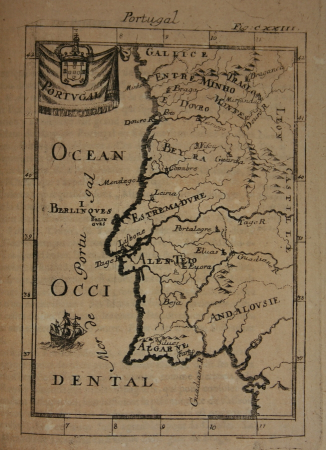
1680s maps of portugal
description de l'universe
1685 maps of europe
description de l'universe
1685 maps of europe
1685 maps of the caribbean
description de l'universe
description de l'universe
1680s maps of germany
description de l'universe
1685 maps of europe
description de l'universe
1685 maps of the bahamas
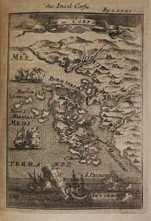
17th-century maps of italy
description de l'universe
17th-century maps of bavaria
description de l'universe
nova & accurata ducatuum slesvici et holsatiae tabula
turgot map of paris, david rumsey historical map collection – derivative files
petit-gentilly
untrodden peaks and unfrequented valleys (1873)
old maps of the alps
old maps of the dutch east india company
1705
maps of kodagu district
edward weller
map of ghent by jan blaeu
elbe in brunsbüttel
brunsbüttel
german renaissance,humanism
old maps of cairo
maps of arnhem by braun & hogenberg
maps of venlo by braun & hogenberg
maps in the library of congress
1861 maps of virginia
arnold van langren map of southwest africa
renaissance
maps by willem and johannes blaeu
1635 maps
maps by willem and johannes blaeu
1635 maps
daniel de la feuille
1706 maps of italy
maps of the west-indische compagnie
1665
copper engravings
1619 engravings
civitates orbis terrarum. urbium praecipuarum totius mundi. liber quartus
maps of sloten by braun & hogenberg
beschreibung und contrafactur der vornembster stät der welt, liber primus civitates orbis terrarum
maps of siena by braun & hogenberg
tresor des cartes geographiques (1659)
1650s maps of eastern europe
beschreibung und contrafactur der vornembster stät der welt, liber primus civitates orbis terrarum
maps of azemmour by braun & hogenberg
beschreibung und contrafactur der vornembster stät der welt, liber primus civitates orbis terrarum
maps of málaga by braun & hogenberg
tresor des cartes geographiques (1659)
17th-century maps of siberia
tresor des cartes geographiques (1659)
old maps of tunis
beschreibung und contrafactur der vornembster stät der welt, liber primus civitates orbis terrarum
maps of 's-hertogenbosch by braun & hogenberg
hamburgische elbkarte von melchior lorichs
parts of old maps of hamburg
beschreibung und contrafactur der vornembster stät der welt, liber primus civitates orbis terrarum
maps of aden by braun & hogenberg
beschreibung und contrafactur der vornembster stät der welt, liber primus civitates orbis terrarum
maps of wesel by braun & hogenberg
beschreibung und contrafactur der vornembster stät der welt, liber primus civitates orbis terrarum
maps of 's-hertogenbosch by braun & hogenberg
beschreibung und contrafactur der vornembster stät der welt, liber primus civitates orbis terrarum
maps of kozhikode by braun & hogenberg
beschreibung und contrafactur der vornembster stät der welt, liber primus civitates orbis terrarum
maps of nördlingen by braun & hogenberg
beschreibung und contrafactur der vornembster stät der welt, liber primus civitates orbis terrarum
maps of heidelberg by braun & hogenberg
a & c black general atlas of the world
1850s maps of the world
maps of frankfurt-innenstadt
maps of frankfurt-nordend
german renaissance
old maps of venice
locator maps of the harbour of rotterdam
zalmhaven (rotterdam)
navigantium atque itinerantium bibliotheca
1764 fleurons
maps of brussels city walls
old maps of brussels
maps by william home lizars
old maps of sydney
old maps of north rhine-westphalia
baroque
atlas des anciens plans de paris by imprimerie nationale, 1880 from the musée carnavalet
maps of paris from paris musées
africa and its inhabitants, vol. ii
charles eugène perron
eran laor cartographic collection
pierre aveline
17th-century maps of italy
description de l'universe
description de l'universe
old maps of scotland
description de l'universe
1685 maps of europe
17th-century maps of france
description de l'universe
description de l'universe
old maps of north america
17th-century maps of italy
description de l'universe
old maps of the united states
description de l'universe
17th-century maps of guyana
description de l'universe
description de l'universe
1680s maps of cyprus
17th-century maps of italy
description de l'universe
maps from the earth and its inhabitants, vol. x
1890 maps of africa
prints in the stadsarchief amsterdam
map of amsterdam, 1544
map of paris by jouvin de rochefort (boutier 112)
pont de grammont
maps of goa by linschoten
portuguese india
boreray, st kilda
maps of st kilda
nouvelle géographie universelle, vol. xii
charles eugène perron
maps by jodocus hondius
maps by petrus bertius
nouvelle géographie universelle, vol. xii
charles eugène perron
description de l'universe
1685 maps of europe
description de l'universe
old maps of lemnos
description de l'universe
old maps of canada
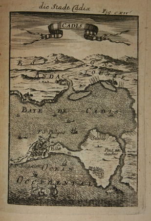
description de l'universe
old maps of cádiz
description de l'universe
1680s maps of brazil
description de l'universe
old maps of french guiana
description de l'universe
1685 maps of europe
description de l'universe
1680s maps of germany
description de l'universe
17th-century maps of cuba
17th-century maps of france
description de l'universe
glaciers and glaciation (1910)
maps of glaciers of alaska
15801 - 15900 of 38,713
Next page
/ 388


![Beschreibung und Contrafactur der Vornembster stät der Welt, liber primus [Civities of the World], 1574](https://cdn.creazilla.com/illustrations/10000237213/beschreibung-und-contrafactur-der-vornembster-stt-der-welt-liber-primus-civities-of-the-world-1574-sm.webp)
![Treasure of geographical maps of the main states of the universe [...], 1659](https://cdn.creazilla.com/illustrations/10000594631/treasure-of-geographical-maps-of-the-main-states-of-the-universe-1659-sm.webp)
![Beschreibung und Contrafactur der Vornembster stät der Welt, liber primus [Civities of the World], 1574](https://cdn.creazilla.com/illustrations/10000539145/beschreibung-und-contrafactur-der-vornembster-st-t-der-welt-liber-primus-civities-of-the-world-1574-sm.jpg)
![Beschreibung und Contrafactur der Vornembster stät der Welt, liber primus [Civities of the World], 1574](https://cdn.creazilla.com/illustrations/10000408860/beschreibung-und-contrafactur-der-vornembster-stt-der-welt-liber-primus-civities-of-the-world-1574-sm.webp)
![Treasure of geographical maps of the main states of the universe [...], 1659](https://cdn.creazilla.com/illustrations/10001176343/treasure-of-geographical-maps-of-the-main-states-of-the-universe-1659-sm.jpg)
![Treasure of geographical maps of the main states of the universe [...], 1659](https://cdn.creazilla.com/illustrations/10000832962/treasure-of-geographical-maps-of-the-main-states-of-the-universe-1659-md.jpg)
![Beschreibung und Contrafactur der Vornembster stät der Welt, liber primus [Civities of the World], 1574](https://cdn.creazilla.com/illustrations/10000649256/beschreibung-und-contrafactur-der-vornembster-st-t-der-welt-liber-primus-civities-of-the-world-1574-sm.jpg)

![Beschreibung und Contrafactur der Vornembster stät der Welt, liber primus [Civities of the World], 1574](https://cdn.creazilla.com/illustrations/10001083437/beschreibung-und-contrafactur-der-vornembster-stt-der-welt-liber-primus-civities-of-the-world-1574-sm.webp)
![Beschreibung und Contrafactur der Vornembster stät der Welt, liber primus [Civities of the World], 1574](https://cdn.creazilla.com/illustrations/10001053923/beschreibung-und-contrafactur-der-vornembster-stt-der-welt-liber-primus-civities-of-the-world-1574-sm.webp)
![Beschreibung und Contrafactur der Vornembster stät der Welt, liber primus [Civities of the World], 1574](https://cdn.creazilla.com/illustrations/10001057342/beschreibung-und-contrafactur-der-vornembster-st-t-der-welt-liber-primus-civities-of-the-world-1574-sm.jpg)
![Beschreibung und Contrafactur der Vornembster stät der Welt, liber primus [Civities of the World], 1574](https://cdn.creazilla.com/illustrations/10001037322/beschreibung-und-contrafactur-der-vornembster-stt-der-welt-liber-primus-civities-of-the-world-1574-sm.webp)
![Beschreibung und Contrafactur der Vornembster stät der Welt, liber primus [Civities of the World], 1574](https://cdn.creazilla.com/illustrations/10000869579/beschreibung-und-contrafactur-der-vornembster-st-t-der-welt-liber-primus-civities-of-the-world-1574-sm.jpg)
![Beschreibung und Contrafactur der Vornembster stät der Welt, liber primus [Civities of the World], 1574](https://cdn.creazilla.com/illustrations/10001520412/beschreibung-und-contrafactur-der-vornembster-st-t-der-welt-liber-primus-civities-of-the-world-1574-sm.jpg)