Log in
All resources
Create a design
38,713 Free Artworks of Map
bibliothèque nationale de france
gemeente atlas van nederland - south holland
1860s maps of south holland
maps from the earth and its inhabitants, vol. xiii
maps by willem and johannes blaeu
maps indicating exploration
university of texas at arlington
english-language maps
latin-language maps
map of bruges by marcus gheeraerts (i)
1777 maps of new york (state)
maps of the hudson river
maps from traité de la police, bibliothèque nationale de france
first map of paris from traité de la police
recueil d'antiquités égyptiennes, étrusques, greques et romaines (1752)
18th-century maps of paris
maps of the west-indische compagnie
old maps of dutch brazil
maps by louis brion de la tour
1766 maps of africa
maps by daniel lizars
1831 maps of mexico
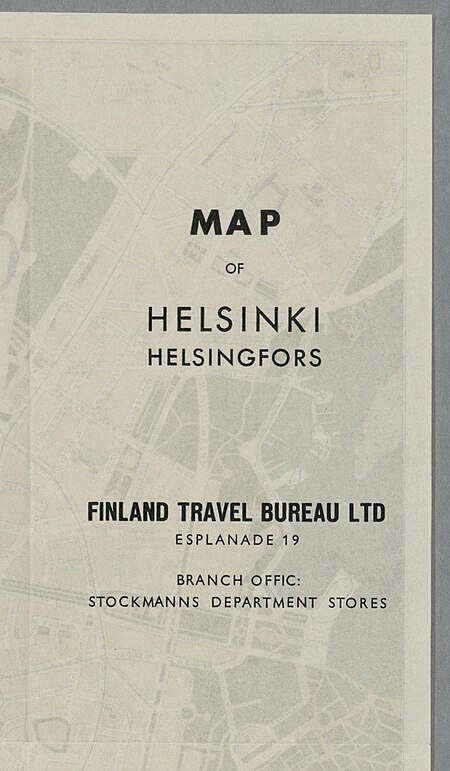
media from the national library of finland
classicism
maps of bratislava by braun & hogenberg
eran laor cartographic collection
maps by emanuel bowen
negroland
locator maps of municipalities of north holland
maps of anna paulowna
maps of bruges by jacques harrewijn
map of bruges by marcus gheeraerts (i)
drawings in the groeningemuseum
map of bruges by marcus gheeraerts (i)
drawings in the groeningemuseum
maps in the library of congress
1768 maps of north america
maps from the earth and its inhabitants, vol. xiii
maps of africa
maps by richard william seale
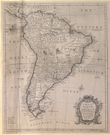
1740s maps of south america
cityscapes of billings, montana
old maps of cities in montana
images of places from encyclopædia britannica
emery walker
gemeente atlas van nederland - south holland
old maps of the hague
gemeente atlas van nederland - south holland
1860s maps of south holland
16th-century maps of slovenia
1589 maps
munich in the 17th century
baroque
old maps of ghent by jacques horenbault
sint-amandsberg
maps from the earth and its inhabitants, vol. xiii
maps of telegraph lines
maps from the earth and its inhabitants, vol. xvi
1870s maps of panama
maps from the earth and its inhabitants, vol. ix
1870s maps of jerusalem
ambroise tardieu
j. p. besançon
18th-century double hemisphere world maps
1730s maps of the world
18th-century double hemisphere world maps
1730s maps of the world
avenionensis ditio et venaisinus comitatus (galleria delle carte geografiche)
maps made in the 17th century
old maps of drenthe
maps by girolamo porro
1598 maps of asia
maps by willem and johannes blaeu
17th-century maps of india
eran laor cartographic collection
avraham leib monsohn
19th-century satirical maps
augusto grossi
map of bruges by marcus gheeraerts (i)
1562 maps
maps of tintin
borduria
media from regionaal archief alkmaar
old maps of schagen
maps of the west-indische compagnie
1705 maps of africa
19th-century maps of nord (department)
19th-century maps of pas-de-calais
old maps of algiers
maps from gallica
images of places from encyclopædia britannica
old maps of glasgow
gemeente atlas van nederland - south holland
old maps of brielle
gemeente atlas van nederland - south holland
19th-century maps of rotterdam
18th-century maps of korea
nouvel atlas de la chine
1790s maps of the world
rangaku
maps by willem and johannes blaeu
siege of 's-hertogenbosch
curt teich postcard archives
map postcards
maps from the earth and its inhabitants, vol. x
damietta branch
old maps of virginia in the american civil war
1863 maps of west virginia
maps from the earth and its inhabitants, vol. iii
linguistic maps of the balkans
maps from the earth and its inhabitants, vol. vii
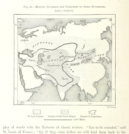
maps of the mongol empire
maps from the earth and its inhabitants, vol. xiii
maps indicating exploration
maps from the earth and its inhabitants, vol. iii
1870s maps of belgium
maps from the earth and its inhabitants, vol. v
1870s maps of norway
maps from the earth and its inhabitants, vol. vii
1878 maps of asia
maps from the earth and its inhabitants, vol. vi
maps of weather and climate of asia
maps from the earth and its inhabitants, vol. xvi
1870s maps of panama
maps from the earth and its inhabitants, vol. vi
maps of the history of russia
18th-century maps of panama
war of jenkins' ear
maps indicating exploration
1885 maps
maps from the earth and its inhabitants, vol. viii
1870s maps of india
maps from the earth and its inhabitants, vol. xi
1870s maps of tunisia
maps from the earth and its inhabitants, vol. ix
1870s maps of jerusalem
maps from the earth and its inhabitants, vol. v
1870s maps of russia
maps from the earth and its inhabitants, vol. ix
maps indicating exploration
maps from the earth and its inhabitants, vol. viii
1870s maps of india
17th-century maps of southeast asia
maps by girolamo porro
maps from the mechanical curator collection
australia (1873) by booth
1600s maps of belgium
old maps of flanders
maps by pieter van der keere
old maps of utrecht
maps by pieter van der keere
willem barentsz
maps by nicolaes visscher i
atlas van der hagen
hendrik van langren map of south asia
1596 maps of asia
maps by william home lizars
maps by daniel lizars
maps in the library of congress
1877 maps of the united states
john rocque 1746 london map (a1-h3)
st george's fields, southwark
18th-century maps of barbados
1780 maps of the caribbean
maps of spain by tomas lopez
1770 maps of spain
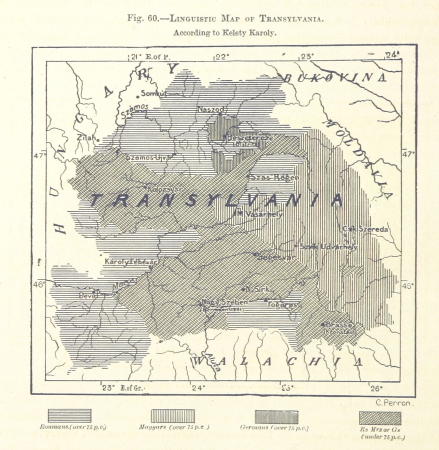
maps from the earth and its inhabitants, vol. xiii
exploration of africa
cartes de franz schrader
gavarnie
1890s maps of ethiopia
fra mauro map details
description de l'universe
old maps of greece
maps by jacques chiquet
1719 maps of africa
1749 maps of the russian empire
hendrik de leth
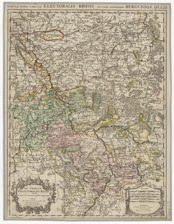
map of the circle of the rhineland by sanson
1700s maps of rhineland-palatinate
maps by willem and johannes blaeu
old maps of coevorden
gemeente atlas van nederland - south holland
maps of zoeterwoude
17th-century maps of iceland
iceland map by joris carolus
map of ghent by jan blaeu
map of ghent by abraham casteleyn
abraham casteleyn
miniature speed atlas (1627) pieter van den keere
old county maps of lincolnshire
old maps of trinidad and tobago
17th-century maps of venezuela
maps in the library of congress
18th-century maps of jamaica
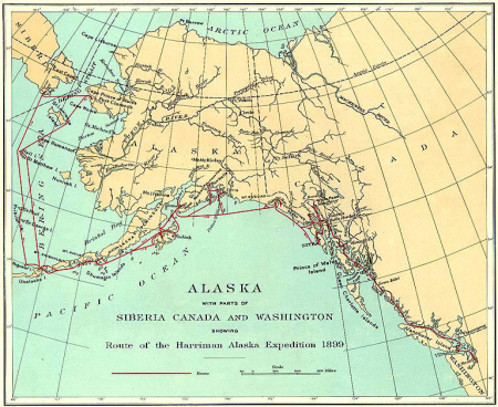
1900s maps of alaska
silver
merian hassiae
baroque
le sénégal. la france dans l'afrique occidentale (1889)
orientalist painting
maps of bordeaux by braun & hogenberg
maps of nîmes by braun & hogenberg
old maps of cities in switzerland
maps of biel/bienne
maps by willem and johannes blaeu
old maps of leiden
14401 - 14500 of 38,713
Next page
/ 388


![Lutetia or first plan of the city of Paris taken from Cesar, Strabo, the Emperor Julian and Ammiam Marcellin [Digitized still image] / By MLCDLM, Antoine Coquart](https://cdn.creazilla.com/illustrations/10001210581/lutetia-or-first-plan-of-the-city-of-paris-taken-from-cesar-strabo-the-emperor-julian-and-ammiam-marcellin-digitized-still-image-by-mlcdlm-antoine-coquart-sm.webp)


![Part of Africa [Northwest], William Home Lizars, circa 1825](https://cdn.creazilla.com/illustrations/10001266032/part-of-africa-northwest-william-home-lizars-circa-1825-md.jpg)