Log in
All resources
Create a design
38,713 Free Artworks of Map
maps from university of amsterdam special collections
atlas der neederlanden
atlas der neederlanden deel iii: holland 2. zuid-holland
old maps of delfland
nicolaas samuel crucquius
copperplate print
special collections of the university of amsterdam
bibliothèque nationale de france
eran laor cartographic collection
maps from the earth and its inhabitants, vol. xiii
hamburgische elbkarte von melchior lorichs
parts of old maps of hamburg
1580s maps of the netherlands
1580s maps of belgium
images of places from encyclopædia britannica
old maps of edinburgh
maps by jodocus hondius
copper engravings
hamburgische elbkarte von melchior lorichs
maps of hamburg-moorburg
map of the upper rhenian circle by sanson
maps by nicolas sanson
maps of the kingdom of seville
maps of spain by tomas lopez
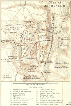
r. hausermann, carte de la terre sainte, 1914
eran laor cartographic collection
maps from the earth and its inhabitants, vol. xii
1710s maps of africa
maps from the earth and its inhabitants, vol. iv
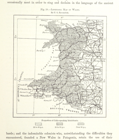
linguistic maps of wales
maps from the earth and its inhabitants, vol. xiii
maps of orange free state
maps from the earth and its inhabitants, vol. xiv
19th-century maps of borneo
kobe foreign settlement
old maps of kobe
maps of the kingdom of seville
maps of spain by tomas lopez
maps of the kingdom of seville
maps of spain by tomas lopez
kaart van het hoogheemraadschap van schieland, 1611-1635
maps of delfshaven
old maps of the london underground
maps by macdonald gill
maps by pieter mortier
old maps of genoa
gemeente atlas van nederland - south holland
1860s maps of south holland
maps by willem and johannes blaeu
1665 maps
1590s maps of the world
maps by girolamo porro
map of the german empire by louis stanislas d'arcy de la rochette
1780s maps of lithuania
1660s maps of spain
1667 maps
zehn karten und ansichten den schlachtfelden des amerikanischen unabhängigkeitskreiges in den staaten pennsylvanien und new york
maps in the library of congress
maps of valenciennes city walls
old maps of valenciennes
maps by pieter van der keere
ships on maps
maps in the library of congress
1780s maps of cuba
zehn karten und ansichten den schlachtfelden des amerikanischen unabhängigkeitskreiges in den staaten pennsylvanien und new york
maps in the library of congress
maps of paris from bibliothèque nationale de france
dheulland map of paris
description de l'universe
old maps of asia
bird's eye view of knoxville, tennessee, 1886
maps in the library of congress
map of italy by guillaume delisle (1700)
eran laor cartographic collection
maps from the earth and its inhabitants, vol. xiii
africa in the 1890s
maps from the earth and its inhabitants, vol. xi
africa in the 1890s
city map of regensburg (1700)
obermünster (regensburg)
maps from university of amsterdam special collections
atlas der neederlanden
maps from university of amsterdam special collections
atlas der neederlanden
maps from university of amsterdam special collections
atlas der neederlanden
maps from university of amsterdam special collections
atlas der neederlanden
maps from university of amsterdam special collections
atlas der neederlanden
maps from university of amsterdam special collections
atlas der neederlanden
gemeente atlas van nederland - south holland
1860s maps of south holland
algeria in the 1880s
old maps of algeria
guide joanne espagne et portugal-1906
french-language maps of spain
miniature speed atlas (1627) pieter van den keere
county maps of england by john speed
miniature speed atlas (1627) pieter van den keere
county maps of england by john speed
miniature speed atlas (1627) pieter van den keere
county maps of england by john speed
old maps of england
1860 maps
matteo pagano della fede
knin
satellite pictures of the eastern hemisphere
fra mauro map derivative works
map of ghent by harrewijn
jacobus harrewijn
old submaps of paris 5e arrondissement
porte saint-victor (paris)
map of paris by braun & hogenberg - derivative files
rue de braque on maps
1857 maps of illinois
1850s maps of chicago
africa and its inhabitants, vol. ii
charles eugène perron
eran laor cartographic collection
latin-language maps
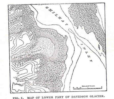
glaciers and glaciation (1910)
maps of glaciers of alaska
1665 maps of ukraine
1665 maps
hamburgische elbkarte von melchior lorichs
parts of old maps of hamburg
19th-century maps of west africa
maps by thomas starling
eran laor cartographic collection
theodor de bry
maps from the earth and its inhabitants, vol. ix
old maps of the holy land
maps of nieuwpoort, south-holland
vestingwerken nieuwpoort
fra mauro map by sector
maps from the earth and its inhabitants, vol. iv
maps of lewis, scotland
maps in the british museum
udenheim
gemeente atlas van nederland - south holland
1860s maps of south holland
maps by willem and johannes blaeu
1649 maps
images of places from encyclopædia britannica
1910s maps of london
maps from the earth and its inhabitants, vol. xii
1892 in africa
old maps of ghent by jacques horenbault
old maps of coupure (ghent)
maps by willem and johannes blaeu
old maps of kampen, netherlands
africa and its inhabitants, vol. ii
charles eugène perron
maps from the earth and its inhabitants, vol. xiii
africa in the 1890s
maps from the earth and its inhabitants, vol. xiii
africa in the 1890s
map of bruges by marcus gheeraerts (i)
drawings in the groeningemuseum
maps by jan janssonius
1640s maps of africa
maps by girolamo porro
1600 maps of asia
maps by willem and johannes blaeu
old maps of axel
old maps of ravenstein, germany
maps made in the 17th century
eran laor cartographic collection
pierre françois tardieu
eran laor cartographic collection
thomas kitchin
map of the circle of the rhineland by sanson
1680s maps of rhineland-palatinate
maps from university of amsterdam special collections
atlas der neederlanden
maps from university of amsterdam special collections
atlas der neederlanden
maps from university of amsterdam special collections
atlas der neederlanden
maps from university of amsterdam special collections
atlas der neederlanden
maps from university of amsterdam special collections
atlas der neederlanden
maps from university of amsterdam special collections
atlas der neederlanden
maps from university of amsterdam special collections
atlas der neederlanden
maps from university of amsterdam special collections
atlas der neederlanden
history of bernkastel-kues
city walls of bernkastel
maps from university of amsterdam special collections
atlas der neederlanden
maps from university of amsterdam special collections
atlas der neederlanden
maps from university of amsterdam special collections
atlas der neederlanden
maps from university of amsterdam special collections
atlas der neederlanden
16th-century maps of the philippines
maps by pieter van der keere
maps by john cary
1799 maps
everett d. graff collection of western americana
maps of the nez perce war
cornell's primary geography (1860)
1867 maps of africa
14101 - 14200 of 38,713
Next page
/ 388


![[Ten maps and views of the battlefields of the American Revolutionary War in the states of Pennsylvania and New York], 1777](https://cdn.creazilla.com/illustrations/10000484458/ten-maps-and-views-of-the-battlefields-of-the-american-revolutionary-war-in-the-states-of-pennsylvania-and-new-york-1777-md.jpg)


![[Ten maps and views of the battlefields of the American Revolutionary War in the states of Pennsylvania and New York], 1777](https://cdn.creazilla.com/illustrations/10001455242/ten-maps-and-views-of-the-battlefields-of-the-american-revolutionary-war-in-the-states-of-pennsylvania-and-new-york-1777-md.jpg)