Log in
All resources
Create a design
38,713 Free Artworks of Map
bibliothèque nationale de france
eran laor cartographic collection
maps by willem and johannes blaeu
maps in the british museum
paper
british museum
english-language maps
emanuel bowen
gemeente atlas van nederland - south holland
1860s maps of south holland
turgot map of paris, bibliothèque nationale de france
maps of paris from bibliothèque nationale de france
turgot map of paris, bibliothèque nationale de france
maps of paris from bibliothèque nationale de france
gemeente atlas van nederland - north holland
19th-century maps of amsterdam
maps from the mechanical curator collection available to georeference
maps from the mechanical curator collection
maps by emanuel bowen
1747 maps of africa
maps from the mechanical curator collection available to georeference
maps from the mechanical curator collection
maps in the library of congress
1758 maps
eran laor cartographic collection
michael burghers
maps of the kingdom of kongo
maps by petrus bertius
eran laor cartographic collection
emanuel bowen
eran laor cartographic collection
michael burghers
historical images of the jardin du luxembourg
maps of jardin du luxembourg
maps of the yucatan peninsula
1801 maps of north america
maps of paris from the university of wisconsin-milwaukee libraries
18th-century maps of paris
19th-century maps of tibet
details of old maps
illuminated manuscripts in the museo correr
pietro vesconte
map of the circle of austria by sanson
1670s maps of austria
map of the circle of austria by sanson
1690s maps of austria
maps by johann christoph weigel
maps by christoph weigel
media from the national library of finland
classicism
maps by willem and johannes blaeu
old maps of zwolle
maps of cambridge by braun & hogenberg
matthew parker
maps of alsace by guillaume sanson
maps by alexis-hubert jaillot
map of the circle of austria by sanson
1690s maps of austria
illustrations from découverte de la terre
19th-century maps of cities
atlas geographico del reyno de españa e islas adjacentes (1757)
1757 maps of spain
16th-century maps of southeast asia
maps by girolamo porro
maps from the earth and its inhabitants, vol. xii
africa in the 1890s
old maps of algiers
maps from gallica
sanborn maps of manhattan published in 1903
gramercy park
gemeente atlas van nederland - south holland
1860s maps of south holland
maps in the british museum
maps by pieter mortier
gemeente atlas van nederland - south holland
old maps of eiland van dordrecht
english county maps by john ogilby
old county maps of middlesex
18th-century maps of new orleans
maps in the library of congress
chicago and the midwest, newberry library
maps by rand mcnally
eran laor cartographic collection
emanuel bowen
armillary spheres in art
1770s maps of the world
historical images of the moscow kremlin
17th-century maps of moscow
historical images of the hôtel d'angoulême lamoignon
turgot map of paris – derivative files
maps by willem and johannes blaeu
old maps of the republic of genoa
gemeente atlas van nederland - south holland
strevelshoek
old maps of hugli-chuchura
chinsurah
führer durch dalmatien (1899)
old maps of dalmatia
eran laor cartographic collection
jean-claude richard de saint-non
maps in the british museum
georg friedrich schmidt
tourism advertising posters of germany
1935 maps of germany
monsters on maps
ships on maps
old maps of fictional countries
old maps of new zealand
maps by wilhelm maximilian carpelan
19th-century maps of stockholm
maps by willem and johannes blaeu
maps of gulf of khambhat
jodocus hondius ii, nova totius terrarum orbis geographica ac hydrographica tabula, 1636
map
1660s maps of spain
1667 maps
1660s maps of spain
1667 maps
maps by emanuel bowen
robert sayer
everett d. graff collection of western americana
maps by g. w. & c. b. colton & co.
maps from the mechanical curator collection available to georeference
maps from the mechanical curator collection
maps of tangier by braun & hogenberg
maps of asilah by braun & hogenberg
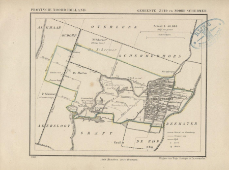
gemeente atlas van nederland - north holland
maps of schermer
old maps of kea (cyclades)
description de l'universe
landais & oberthur
maps from gallica
19th-century double hemisphere world maps
1800s maps of the world
maps from the earth and its inhabitants, vol. xii
africa in the 1890s
maps from the earth and its inhabitants, vol. xii
africa in the 1890s
maps in the british museum
old maps of dunkerque
17th-century maps of the mediterranean sea
description de l'universe
siege of geertruidenberg 1593
maps of geertruidenberg
maps from the earth and its inhabitants, vol. vi
old maps of kyrgyzstan
maps from the earth and its inhabitants, vol. vi
old maps of kyrgyzstan
maps from the earth and its inhabitants, vol. iv
falkirk
16th-century maps of the indian ocean
renaissance
gemeente atlas van nederland - south holland
1860s maps of south holland
maps from the earth and its inhabitants, vol. x
1890 maps of africa
1858 van de velde maps of palestine and jerusalem
1850s maps of lebanon
maps from the mechanical curator collection
1887 maps of sudan
maps of tunis by braun & hogenberg
eran laor cartographic collection
william hole (engraver)
michael drayton
17th-century maps of bremen (state)
1600s maps of lower saxony
files based of data provided by the czech office for surveying and cadastre
svatý mikuláš (kutná hora district)
maps in the british museum
maps by john cary
monsters on maps
ships on maps
maps by willem and johannes blaeu
old maps of bolsward
maps of paris from paris musées
dheulland map of paris
sea of japan naming dispute
18th-century maps of japan
maps in the library of congress
maps of alexandria, virginia
eran laor cartographic collection
german renaissance,humanism
eran laor cartographic collection
german renaissance,humanism
maps of liège in the 17th century
baroque
gemeente atlas van nederland - south holland
maps of heenvliet
maps made in the 17th century
old maps of lindau (bodensee)
maps of spain by tomas lopez
1760 maps of spain
maps in the british museum
georg friedrich schmidt
maps in the british museum
georg friedrich schmidt
19th-century maps of the ottoman empire
maps in the british museum
maps from the earth and its inhabitants, vol. vi
georgia in the 1890s
maps of paris from bibliothèque nationale de france
nouveau plan de paris by louis brion de la tour
old maps of piedmont
maps by gerard valck
atlas novus (blaeu)
1640s maps of paris
1640s maps of asia
stefano scolari
1660s maps of spain
1667 maps
13401 - 13500 of 38,713
Next page
/ 388

![Map of Paris / Drawn and engraved, under the orders of Messire Michel Etienne Turgot [...] Surveyed and drawn by Louis Bretez, engraved by Claude Lucas, and written by Aubin](https://cdn.creazilla.com/illustrations/10001233687/map-of-paris-drawn-and-engraved-under-the-orders-of-messire-michel-etienne-turgot-surveyed-and-drawn-by-louis-bretez-engraved-by-claude-lucas-and-written-by-aubin-md.jpg)
![Map of Paris / Drawn and engraved, under the orders of Messire Michel Etienne Turgot [...] Surveyed and drawn by Louis Bretez, engraved by Claude Lucas, and written by Aubin](https://cdn.creazilla.com/illustrations/10000442000/map-of-paris-drawn-and-engraved-under-the-orders-of-messire-michel-etienne-turgot-surveyed-and-drawn-by-louis-bretez-engraved-by-claude-lucas-and-written-by-aubin-md.jpg)


![Tingis, Lusitanis, Tangiara; Tzaffin; Septa; Arzilla; Sala / [Georg Braun]; [Franz Hogenberg], 1572](https://cdn.creazilla.com/illustrations/10000766715/tingis-lusitanis-tangiara-tzaffin-septa-arzilla-sala-georg-braun-franz-hogenberg-1572-md.jpg)