Log in
All resources
Create a design
38,713 Free Artworks of Map
bibliothèque nationale de france
gemeente atlas van nederland - south holland
1860s maps of south holland
maps of paris from bibliothèque nationale de france
david rumsey historical map collection
eran laor cartographic collection
joan blaeu
john cary
animals on maps
maps by willem and johannes blaeu
old maps of haarlem
atlas van loon
gemeente atlas van nederland - south holland
19th-century maps of rotterdam
gemeente atlas van nederland - south holland
1860s maps of south holland
david rumsey historical map collection
andrew dury
gemeente atlas van nederland - south holland
maps of wateringen
nicolaas samuel crucquius
old maps of delfland
the generall historie of virginia (john smith)
1624 engravings
david rumsey historical map collection
1790s maps of the holy roman empire
old maps of cambridge
1690 maps of england
maps in cosmographia (münster)
old maps of kempten (allgäu)
gemeente atlas van nederland - south holland
19th-century maps of rotterdam
maps from the earth and its inhabitants, vol. vii
charles eugène perron
cornell: persuasive cartography: the pj mode collection
europe in the 1870s
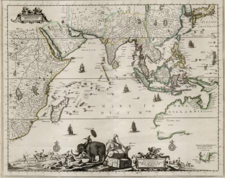
18th-century maps of the malay archipelago
18th-century maps of southeast asia
maps from the earth and its inhabitants, vol. xii
africa in the 1890s
images of places from encyclopædia britannica
1911 in berlin-spandau
old maps of brussels
jacobus harrewijn
considérations géographiques et physiques sur les nouvelles découvertes au nord de la grande mer
1755 maps of north america
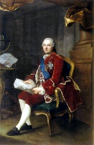
18th-century portrait paintings in the musée national du château de versailles
star of the order of the holy spirit in portrait paintings
maps by john cary
1801 maps
1820s maps of indonesia
old maps of east timor
old maps of the republic of genoa
maps of the duchy of milan
maps of kozhikode by braun & hogenberg
eran laor cartographic collection
maps of the iberian peninsula by guillaume delisle
1780s maps of the iberian peninsula
hendrik van langren map of south asia
renaissance
robert hermann schomburgk
maps by john arrowsmith
map of rome by giovanni battista falda (1676)
maps in the rijksmuseum amsterdam
maps of colonial brazil
1510s maps of brazil
gemeente atlas van nederland - south holland
1860s maps of south holland
atlas van der hagen (volume 3)
atlas van der hagen
eran laor cartographic collection
french-language maps
images in ottův slovník naučný (volume 6)
maps in ottův slovník naučný
maps indicating exploration
royal geographical society
monomotapa
mutapa
maps of mecklenburg-schwerin
old maps of mecklenburg
18th-century maps of the indian ocean
18th-century maps of southeast asia
old maps of great britain
1250s maps
fra mauro map by sector
vlachs
maps of kraków
planty
ptolemy's 3rd african map
1477 maps
maps by pieter mortier
indochina
the odyssey (butler)
maps of the odyssey
jan karel donatus van beecq
hernán cortés
glaciers and glaciation (1910)
maps of glacier bay
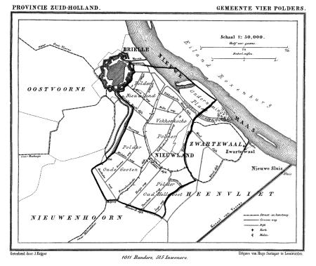
gemeente atlas van nederland - south holland
old maps of brielle
maps of plymouth, massachusetts
william wood
upper guelders
atlas van loon
maps from the earth and its inhabitants, vol. xi
1891 maps of africa
maps of the golden horde
fra mauro map details
maps by jan eduard wagner
františek kytka
maps in the library of congress
novus atlas sinensis
petit atlas pittoresque des 48 quartiers de la ville de paris, david rumsey historical map collection
maps of paris from the david rumsey historical map collection
maps by john cary
1801 maps
atlas van der hagen (volume 4)
atlas van der hagen
gaspar bouttats
mocha
18th-century maps of tunisia
gulf of tunis
1590s maps of the levant
ptolemy's 4th asian map
john rocque's 1746 map of london
details of old maps of london
maps of paris from bibliothèque nationale de france
battle of saint-denis (1567)
maps of paris from bibliothèque nationale de france
battle of saint-denis (1567)
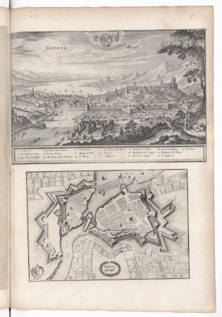
old maps of geneva
baroque
eran laor cartographic collection
john cary
plan routier de la ville et faubourg de paris by jean lattré
maps of paris from bibliothèque nationale de france
miniature speed atlas (1627) pieter van den keere
county maps of england by john speed
delle navigationi et viaggi
italian-language maps
19th-century maps of bohemia
1880s maps of czechia
maps by girolamo porro
1598 maps of russia
maps by willem and johannes blaeu
old maps of utrecht (city)
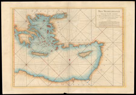
17th-century maps of the eastern mediterranean
1690s maps of turkey
gemeente atlas van nederland - south holland
1860s maps of south holland
maps of paris from paris musées
baroque
hoogheemraadschap rijnland map, 2nd edition, 1687
old maps of haarlem
old maps of the western hemisphere
jacob van meurs
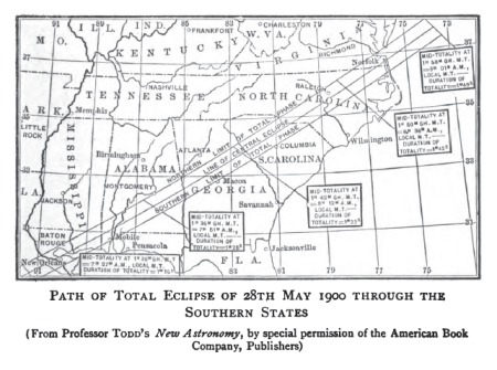
19th-century solar eclipse maps
solar eclipse of 1900 may 28
maps of landkreis elbe-elster
old maps of saxony
latin-language maps
1911 maps
gemeente atlas van nederland - south holland
maps of 's-gravenzande
midden-delfland in the 18th century
maps of midden-delfland
maps in the library of congress
old maps of anniston, alabama
maps of paris from bibliothèque nationale de france
sheet 10 of the turgot map of paris
1529 maps of iran
1529 maps
eran laor cartographic collection
latin-language maps
lutetia parisiorum urbs, toto orbe celeberrima notissimaque caput regni franciæ by sebastian münster
maps of paris from bibliothèque nationale de france
old maps of the coast of england
bodleian maps collection
1830s maps of the world
maps by daniel lizars
eran laor cartographic collection
carolus allard
plan routier de la ville et faubourg de paris by jean lattré
maps of paris from bibliothèque nationale de france
plan routier de la ville et faubourg de paris by jean lattré
maps of paris from bibliothèque nationale de france
maps showing 19th-century history
arctic expeditions
maps of the dutch east india company - iran
old maps of the dutch east india company
historical map collection
maps by john cary
gemeente atlas van nederland - south holland
old maps of katwijk, south holland
old maps of western pomerania
coats of arms on maps
1640s maps of pernambuco
1647 maps of brazil
maps by willem and johannes blaeu
monsters on maps
maps from the earth and its inhabitants, vol. vi
1891 maps of georgia
media from the national library of finland
classicism
maps of paris from the david rumsey historical map collection
baroque
maps with cartouches
old maps of yunnan
russian empire in thomas kitchen's general atlas (1773)
general atlas (1773)
12401 - 12500 of 38,713
Next page
/ 388


![[Nautical Atlas of the World, called Miller Atlas]; 2-5. [Miller Atlas: sheets 2 to 5]. sheet 5, António de Holanda, 1519](https://cdn.creazilla.com/illustrations/10000831902/nautical-atlas-of-the-world-called-miller-atlas-2-5-miller-atlas-sheets-2-to-5-sheet-5-ant-nio-de-holanda-1519-md.jpg)

![Stadsprofiel van] VENETIA, Joan Blaeu, 1704](https://cdn.creazilla.com/illustrations/10000311106/stadsprofiel-van-venetia-joan-blaeu-1704-md.jpeg)


![[Facsimile of part of Turgot's plan (Laune district) used as advertising for the Becker fils house]](https://cdn.creazilla.com/illustrations/10000809874/facsimile-of-part-of-turgot-s-plan-laune-district-used-as-advertising-for-the-becker-fils-house-md.jpg)


