Log in
All resources
Create a design
8,995 Free Images of Scale
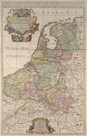
bibliothèque nationale de france
guillaume sanson
maps by willem and johannes blaeu
copperplate print
special collections of the university of amsterdam
historical
maps in the library of congress
maps of spain by tomas lopez
history
maps from university of amsterdam special collections
1670s maps of greece
guillaume sanson
bibliothèque nationale de france
guillaume sanson
drawings and watercolours by thomas rowlandson
romanticism
bibliothèque nationale de france
guillaume sanson
carte des régences d'alger by hérisson
bibliothèque nationale de france
historical
history
historical
history
maps by pieter van der keere
1610s maps of belgium
maps from university of amsterdam special collections
atlas der neederlanden
reverse sides from gallica
history of gelderland
maps by willem and johannes blaeu
robert gordon of straloch
1660s maps of france
old maps of nevers
maps by willem and johannes blaeu
robert gordon of straloch
map of the circle of the rhineland by sanson
1670s maps of hesse
maps by willem and johannes blaeu
17th-century maps of lorraine
bibliothèque nationale de france
guillaume sanson
territorium argentoratense (1652 map)
bibliothèque nationale de france
maps of île-de-france by françois de la guillotière
bibliothèque nationale de france
maps by willem and johannes blaeu
17th-century maps of dombes
bibliothèque nationale de france
novus atlas sinensis
territorium argentoratense (1652 map)
bibliothèque nationale de france
bibliothèque nationale de france
guillaume sanson
map of the strait of kerch by guillaume sanson
bibliothèque nationale de france
bibliothèque nationale de france
guillaume sanson
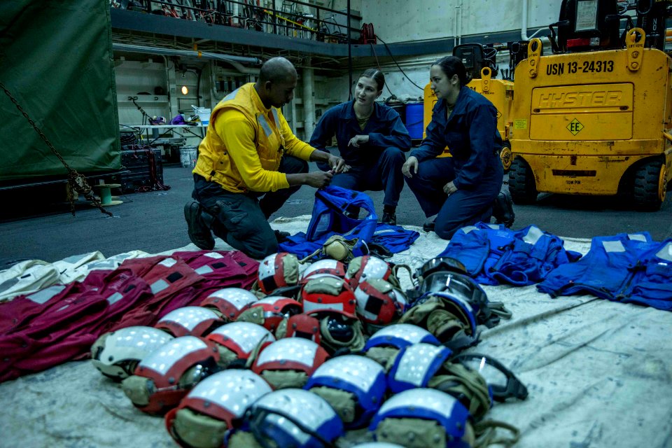
service
awful
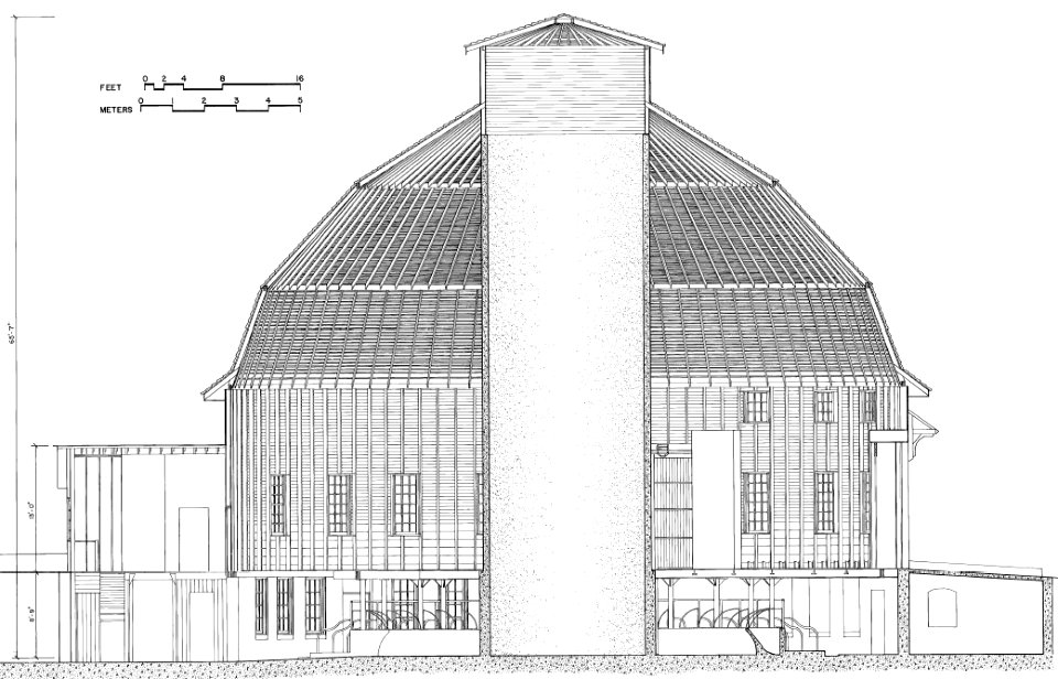
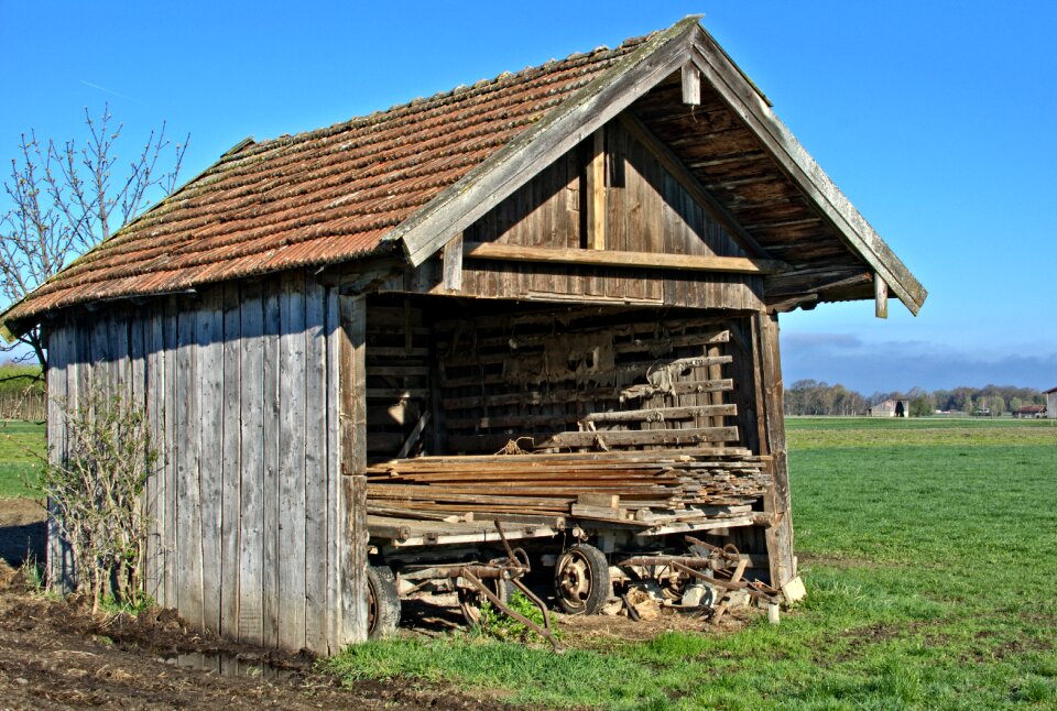
building
nature
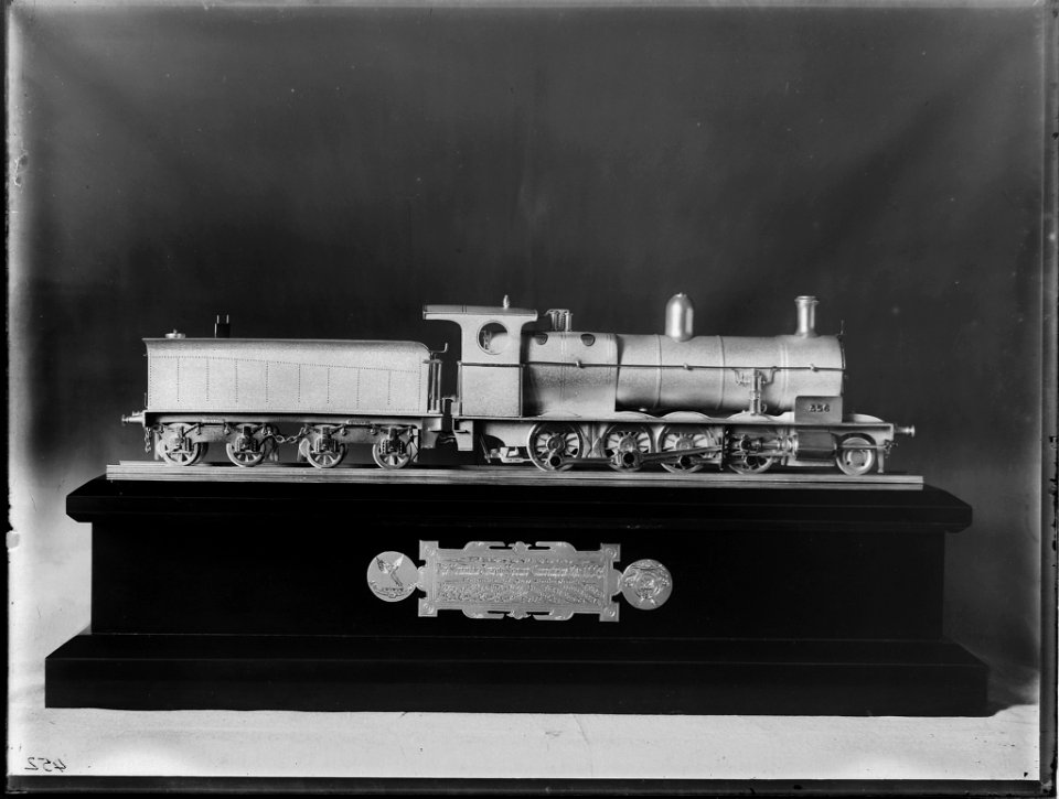
train
usna
maps by pieter van der keere
old maps of gelderland
maps by willem and johannes blaeu
old maps of flanders
maps in the library of congress
1885 maps of new york (state)
1660s maps of france
bresse
atlas vingboons
1665
aircraft
train
maps of abyssinia by mercator-hondius
bibliothèque nationale de france
maps of île-de-france by françois de la guillotière
bibliothèque nationale de france
maps of morocco by mercator-hondius
bibliothèque nationale de france
maps in the library of congress
1886 maps of massachusetts
17th-century maps of luxembourg
maps by pieter van der keere
thomas milton
1739 maps
maps of constantinople by braun & hogenberg
bibliothèque nationale de france
bibliothèque nationale de france
guillaume sanson
maps of constantinople by braun & hogenberg
istanbul in the 1630s
carta hydrographica y chorographica de las yslas filipinas
baroque painting
jesuitenkirche (mainz)
maps of morocco by mercator-hondius
bibliothèque nationale de france
maps by willem and johannes blaeu
17th-century maps of bourgogne
cartouches by willem and johannes blaeu
bibliothèque nationale de france
maps of morocco by mercator-hondius
bibliothèque nationale de france
bibliothèque nationale de france
guillaume sanson
maps of portugal by fernando álvares seco
bibliothèque nationale de france
maps of provence by pierre-jean de bompar
maps by hendrik hondius the younger
map of the strait of kerch by guillaume sanson
bibliothèque nationale de france
maps of île-de-france by françois de la guillotière
bibliothèque nationale de france
maps of the land of valkenburg
guillaume sanson
princess elizabeth of great britain
works after jean-étienne liotard
maps from university of amsterdam special collections
atlas der neederlanden
maps from university of amsterdam special collections
atlas der neederlanden
maps from university of amsterdam special collections
atlas der neederlanden
john rocque 1746 crops from library of congress
maps in the library of congress
maps of the land of valkenburg
guillaume sanson
toy
car
the antiquities of athens (stuart&revett)
greek revival architecture
sanson maps of the netherlands
cartouches by sanson family
the antiquities of athens, vol. ii
greek revival architecture
maps from the earth and its inhabitants, vol. vi
history of uzbekistan
old maps of genoa
nicolò armanino
maps by alexis-hubert jaillot
maps by nicolas sanson
maps from university of amsterdam special collections
atlas der neederlanden
historical
history
charles k. wilkinson
tomb of sennedjem
historical
history
the antiquities of athens (stuart&revett)
greek revival architecture
maps by jan eduard wagner
františek kytka
maps in the library of congress
1780s maps of cuba
old maps of genoa
nicolò armanino
carte des pays-bas catholiques by guillaume sanson
cartouches by sanson family
instagram ad
draft
maps of vangiones by sanson
maps by nicolas sanson
maps of spain by tomas lopez
1783 maps of spain
maps of spain by tomas lopez
1766 maps of spain
maps of spain by tomas lopez
old maps of extremadura
maps of spain by tomas lopez
old maps of castile and león
maps of spain by tomas lopez
old maps of castile and león
historical
history
scale
love
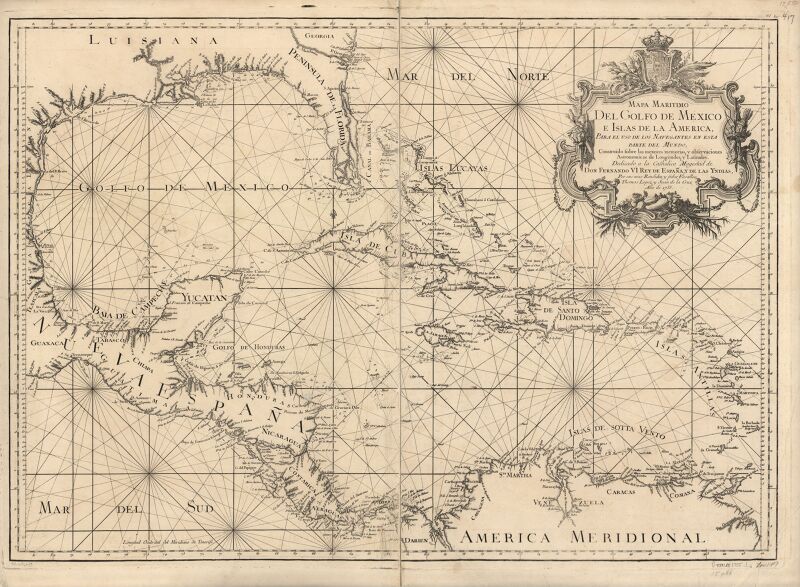
maps in the library of congress
1750s maps of the caribbean
topographisch, oeconomisch und militaerische charte des herzogthums mecklenburg schwerin and des fürstenthums ratzeburg - schmettau
topographisch, oeconomisch und militaerische charte von mecklenburg, schwerin und ratzeburg
territorio di perugia - valerio spada - btv1b53165376s
valerio spada
archevesché d'alby. diocèse d'alby - dressé sur plusieurs memoires par le sieur sanson - btv1b531795087
guillaume sanson
le royaume de france distingué by guillaume sanson
1724 maps of france
topographisch, oeconomisch und militaerische charte des herzogthums mecklenburg schwerin and des fürstenthums ratzeburg - schmettau
topographisch, oeconomisch und militaerische charte von mecklenburg, schwerin und ratzeburg
carte des environs de paris (1678)
bibliothèque nationale de france
sanson maps of the netherlands
1670s maps of the netherlands
maps of spain by tomas lopez
18th-century maps of madrid
maps in the library of congress
1760 maps of north america
carte des environs de paris (1678)
bibliothèque nationale de france
floor plans of abbeys, convents, monasteries in france
couvent des ursulines de montpellier
maps of bologna by braun & hogenberg
bibliothèque nationale de france
bibliothèque nationale de france
cartouches by tomas lópez
carte des environs de paris (1678)
bibliothèque nationale de france
6901 - 7000 of 8,995
Next page
/ 90


![Eastern part of Swedish Lapponia, taken from those of Andr[é] Burae[us] and Isaac Massa / by Sr Sanson, 1666](https://cdn.creazilla.com/illustrations/10000739567/eastern-part-of-swedish-lapponia-taken-from-those-of-andr-buraeus-and-isaac-massa-by-sr-sanson-1666-md.jpg)


![Ager parisiensis vulgo l'Isle de France. Fr. Guilloterius, ... describ[ebat]. CI V Petro Pithoeo I.C., 1640](https://cdn.creazilla.com/illustrations/10001256161/ager-parisiensis-vulgo-lisle-de-france-fr-guilloterius-describebat-ci-v-petro-pithoeo-ic-1640-md.jpg)


![Bosphorus Cimmerius et regnum bosphoranum / ex collectionibus... Gulielmi Sanson... Mille passus 30 [= 0m.064]; stadia 200, 1665](https://cdn.creazilla.com/illustrations/10001442695/bosphorus-cimmerius-et-regnum-bosphoranum-ex-collectionibus-gulielmi-sanson-mille-passus-30-0m-064-stadia-200-1665-sm.jpg)


![Fessae et Marocchi regna / [Jodocus Hondius], 1600s](https://cdn.creazilla.com/illustrations/10001237439/fessae-et-marocchi-regna-jodocus-hondius-1600s-md.jpg)


![Graecia Foederata sub Agamemnone, ob Helenae Raptum in Troiam coniurans / ex Homero collecta geographicis Gulielmi Sanson, Nicolai filii, Christianissimi Regis Geographi; Lud[ovicus] Cordier sculpsit, 1666](https://cdn.creazilla.com/illustrations/10000812945/graecia-foederata-sub-agamemnone-ob-helenae-raptum-in-troiam-coniurans-ex-homero-collecta-geographicis-gulielmi-sanson-nicolai-filii-christianissimi-regis-geographi-lud-ovicus-cordier-sculpsit-1666-md.jpg)


![Fessae et Marocchi regna / [Jodocus Hondius], 1600s](https://cdn.creazilla.com/illustrations/10000708422/fessae-et-marocchi-regna-jodocus-hondius-1600s-md.jpg)


![Fessae et Marocchi regna / [Jodocus Hondius], 1600s](https://cdn.creazilla.com/illustrations/10000787674/fessae-et-marocchi-regna-jodocus-hondius-1600s-md.jpg)


![Bosphorus Cimmerius et regnum bosphoranum / ex colectionibus... Gulielmi Sanson... Mille passus [= 0m.064]; studia 200, 1665](https://cdn.creazilla.com/illustrations/10001580087/bosphorus-cimmerius-et-regnum-bosphoranum-ex-colectionibus-gulielmi-sanson-mille-passus-0m064-studia-200-1665-md.jpg)
![Ager parisiensis vulgo l'Isle de France. Fr. Guilloterius, ... describ[ebat]. CI V Petro Pithoeo I.C., 1640](https://cdn.creazilla.com/illustrations/10001594612/ager-parisiensis-vulgo-l-isle-de-france-fr-guilloterius-describ-ebat-ci-v-petro-pithoeo-i-c-1640-md.jpg)


![The County of Zeelande / draws up new plans based on the memoirs by Mr. Sanson, ordinary geographer to the King, [1692]](https://cdn.creazilla.com/illustrations/10001468571/the-county-of-zeelande-draws-up-new-plans-based-on-the-memoirs-by-mr-sanson-ordinary-geographer-to-the-king-1692-sm.webp)


![Map of the Islands of Japan and the peninsula of Korea: with the coasts of China from Peking to Canton / by N. Bellin; J. v. Schley direx, Jakob van der Schley, [1773]](https://cdn.creazilla.com/illustrations/10000188400/map-of-the-islands-of-japan-and-the-peninsula-of-korea-with-the-coasts-of-china-from-peking-to-canton-by-n-bellin-j-v-schley-direx-jakob-van-der-schley-1773-md.jpg)