Log in
All resources
Create a design
8,995 Free Images of Scale
bibliothèque nationale de france
maps from university of amsterdam special collections
atlas der neederlanden
copperplate print
special collections of the university of amsterdam
large scale exercise 2021
lse21
atlas der neederlanden deel iii: holland 2. zuid-holland
old maps of delfland
nicolaas samuel crucquius
bibliothèque nationale de france
nouvelle géographie universelle
1842 maps of north america
ambroise tardieu
reverse sides from gallica
herman padtbrugge
bibliothèque nationale de france
cartouches by tomas lópez
bibliothèque nationale de france
cartouches by tomas lópez
maps from gallica
guides joanne
maps in the library of congress
18th-century maps of jamaica
carte de moscovie by guillaume de l'isle (1706)
bibliothèque nationale de france
maps from gallica
guides joanne
atlante geografico del regno di napoli (1812)
old maps of ariano irpino
istanbul in the 1780s
maps by tomas lopez
jacques burkhardt scientific drawings
1865 in art
1750s maps of saxony
old maps of leipzig
18th-century maps of the bahamas
18th-century maps of hispaniola
maps of spain by tomas lopez
1779 maps of spain
maps of spain by tomas lopez
old maps of lanzarote
people
light
people
light
the turkish empire in europe, asia and africa (1752)
history of gəncə
the turkish empire in europe, asia and africa (1752)
maps of tabriz
electronics
train
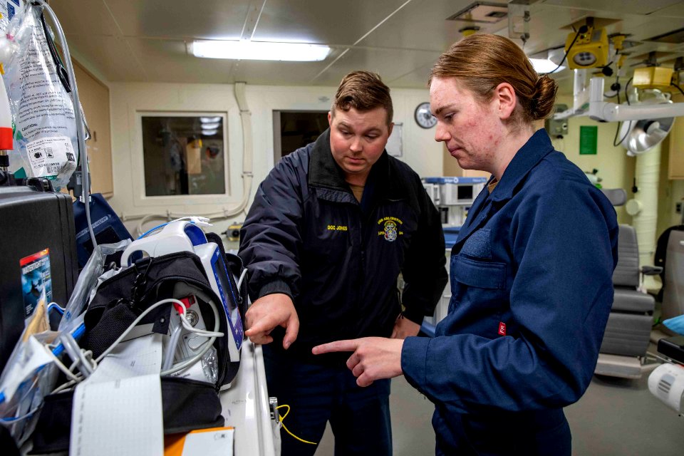
medical
train
people
group
the distillery of apothecary a. d'ailly
paintings in the rijksmuseum
maps from university of amsterdam special collections
atlas der neederlanden
maps from university of amsterdam special collections
atlas der neederlanden
maps from university of amsterdam special collections
atlas der neederlanden
maps from university of amsterdam special collections
atlas der neederlanden
maps from university of amsterdam special collections
atlas der neederlanden
maps from university of amsterdam special collections
atlas der neederlanden
full hd video
draft
building
city
history
forest
1670s maps of the ottoman empire
1679 maps
facebook
draft
antoine-françois tardieu
1800s maps of hispaniola
antoine-françois tardieu
1800s maps of hispaniola
18th-century maps of north africa
maps by tomas lopez
reverse sides from gallica
herman padtbrugge
le royaume de france distingué by guillaume sanson
1724 maps of france
1842 maps of south america
ambroise tardieu
west-indische paskaert (doncker, 1660s)
herman padtbrugge
carte des régences d'alger by hérisson
bibliothèque nationale de france
carte des régences d'alger by hérisson
bibliothèque nationale de france
reverse sides from gallica
herman padtbrugge
map of the circle of bavaria by sanson
bibliothèque nationale de france
maps from gallica
guides joanne
regnorum hispaniae nova descriptio (blaeu)
bibliothèque nationale de france
map of the bosphorus strait by guillaume sanson (1665)
bibliothèque nationale de france
map collection of leibniz-institut für länderkunde
1810s maps of the netherlands
map of the bosphorus strait by guillaume sanson (1665)
bibliothèque nationale de france
18th-century maps of crimea
1780s maps of ukraine
performance
score
illustrations from atti della società degli ingegneri e degli architetti in torino (1889)
palazzo civico (ivrea)
shrine of the three magi, cologne
domschatzkammer köln
maps in the library of congress
1887 maps of massachusetts
old maps of périgueux
1660s maps of france
maps by pieter van der keere
old maps of flanders
maps in the library of congress
1877 maps of the united states
wildlife
nature
astronomy
space
harvest
scale
bibliothèque nationale de france
maps of lothian by timothy pont
maps of provence by pierre-jean de bompar
bibliothèque nationale de france
maps by willem and johannes blaeu
bibliothèque nationale de france
maps of île-de-france by françois de la guillotière
context files from gallica
maps of île-de-france by françois de la guillotière
context files from gallica
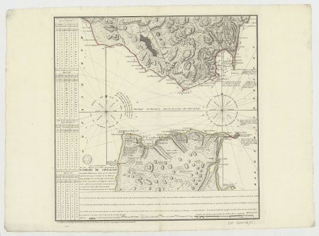
old maps of the strait of gibraltar
1762 maps of spain
paintings by richard roland holst in the rijksmuseum amsterdam
paintings in the rijksmuseum
river stour, suffolk
realism,romanticism
environment
eco
die baudenkmäler in frankfurt am main – band 3, privatbauten
carl theodor reiffenstein
full hd video
draft
full hd video
draft
facebook
draft
maps from university of amsterdam special collections
atlas der neederlanden
maps from university of amsterdam special collections
atlas der neederlanden
furniture in the rijksmuseum amsterdam
willem blaeu
truck
scale
bibliothèque nationale de france
guillaume sanson
maps by guillaume sanson
maps of galatia
old maps of namur (province)
1640s maps of belgium
carte du mexique et de la floride by guillaume delisle (1703)
maps in the library of congress
maps from university of amsterdam special collections
atlas der neederlanden
maps by abraham ortelius
pieter van der keere
maps from university of amsterdam special collections
atlas der neederlanden
historical
history
historical
history
maps from university of amsterdam special collections
atlas der neederlanden
the turkish empire in europe, asia and africa (1752)
historical maps of adana
details of old maps, defaced
maps of erzurum province
chicago and the midwest, newberry library
1703 maps of north america
vehicle
light
18th-century maps of veneto
1700s maps of slovenia
maps of spain by tomas lopez
1761 maps of spain
john rocque 1746 crops from library of congress
john rocque
aircraft
train
postcards of schloss lichtenstein (württemberg)
auf de schwäbsche eisebahne
transport
building
history
forest
6701 - 6800 of 8,995
Next page
/ 90


![The Circle of Bavaria subdivided into all the States which compose it / by Mr. Sanson, ,... A thousand geometric steps or Miles of Italy [30 = 12] common leagues of France, 1703](https://cdn.creazilla.com/illustrations/10000537444/the-circle-of-bavaria-subdivided-into-all-the-states-which-compose-it-by-mr-sanson-a-thousand-geometric-steps-or-miles-of-italy-30-12-common-leagues-of-france-1703-sm.webp)


![Anaplus Bosphori Thracii / ex indagationibus Petri Gyllii; delineatus [a] Gulielmo Sanson..., 1665](https://cdn.creazilla.com/illustrations/10001604206/anaplus-bosphori-thracii-ex-indagationibus-petri-gyllii-delineatus-a-gulielmo-sanson-1665-md.jpg)


![Provincae Lauden seu Lothien et Linlitouo / [Mercator], 1646](https://cdn.creazilla.com/illustrations/10000737732/provincae-lauden-seu-lothien-et-linlitouo-mercator-1646-md.jpg)


![L'Isle de France. Parisiensis agri descrip[tio]. Fr. Guilloterius... describebat..., 1598](https://cdn.creazilla.com/illustrations/10000399587/lisle-de-france-parisiensis-agri-descriptio-fr-guilloterius-describebat-1598-md.jpg)
![L'Isle de France. Parisiensis agri descrip[tio]. Fr. Guilloterius... describebat..., 1598](https://cdn.creazilla.com/illustrations/10001477496/lisle-de-france-parisiensis-agri-descriptio-fr-guilloterius-describebat-1598-md.jpg)


![The Lordship of Groningen subdivided into all its jurisdictions / drawn up on the most recent memoirs by Mr. Sanson, [1708]](https://cdn.creazilla.com/illustrations/10001164695/the-lordship-of-groningen-subdivided-into-all-its-jurisdictions-drawn-up-on-the-most-recent-memoirs-by-mr-sanson-1708-md.jpg)
![The County of Artois / drawn up on the most recent memories, by Mr. Sanson; dedicated to Monseigneur the dauphin, [1692]](https://cdn.creazilla.com/illustrations/10001313165/the-county-of-artois-drawn-up-on-the-most-recent-memories-by-mr-sanson-dedicated-to-monseigneur-the-dauphin-1692-md.jpg)