Log in
All resources
Create a design
8,995 Free Images of Scale
bibliothèque nationale de france
l'asie, en plusieurs cartes nouvelles, et exactes, &c. en divers traitez de geographie, et d'histoire. là où sont descrits succinctement, & avec une belle methode, & facile. ses empires, ses... - btv1b55013761m
maps by nicolas sanson
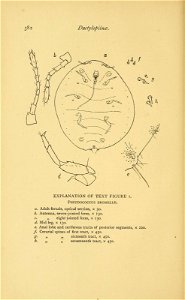
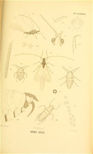
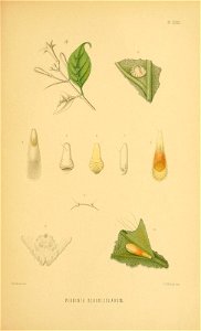
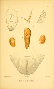
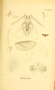
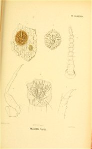
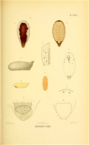
insects
sri lanka
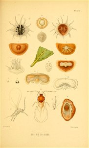
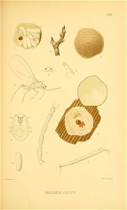
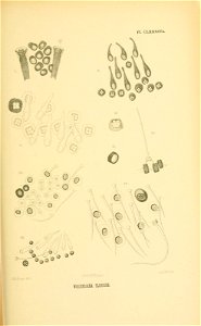
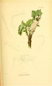
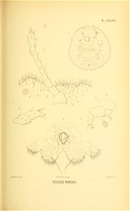
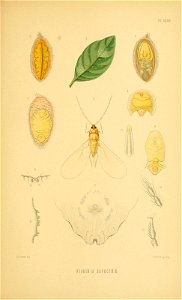
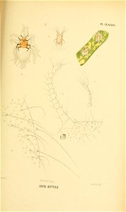
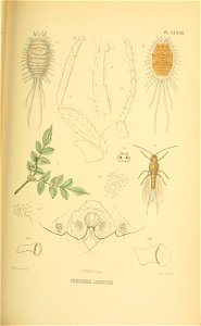
scale insects
smithsonian libraries
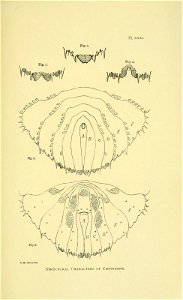
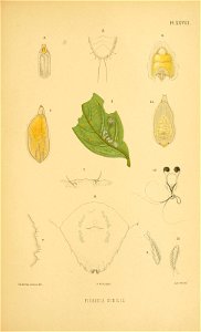
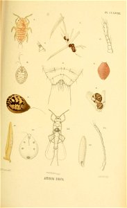
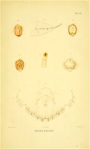
the coccidae of ceylon pt.5 (1922)
the coccidae of ceylon pt.1 (1896)
the coccidae of ceylon pt.2 (1899)
sri lanka
insects
sri lanka
insects
sri lanka
insects
sri lanka
insects
sri lanka
insects
sri lanka
insects
sri lanka
insects
sri lanka
insects
baroque allegorical paintings
antonio zanchi
l'asie, en plusieurs cartes nouvelles, et exactes, &c. en divers traitez de geographie, et d'histoire. là où sont descrits succinctement, & avec une belle methode, & facile. ses empires, ses... - btv1b55013761m
bibliothèque nationale de france
l'asie, en plusieurs cartes nouvelles, et exactes, &c. en divers traitez de geographie, et d'histoire. là où sont descrits succinctement, & avec une belle methode, & facile. ses empires, ses... - btv1b55013761m
maps by nicolas sanson
bibliothèque nationale de france
maps by tomas lopez
l'asie, en plusieurs cartes nouvelles, et exactes, &c. en divers traitez de geographie, et d'histoire. là où sont descrits succinctement, & avec une belle methode, & facile. ses empires, ses... - btv1b55013761m
bibliothèque nationale de france
l'asie, en plusieurs cartes nouvelles, et exactes, &c. en divers traitez de geographie, et d'histoire. là où sont descrits succinctement, & avec une belle methode, & facile. ses empires, ses... - btv1b55013761m
maps by nicolas sanson
l'asie, en plusieurs cartes nouvelles, et exactes, &c. en divers traitez de geographie, et d'histoire. là où sont descrits succinctement, & avec une belle methode, & facile. ses empires, ses... - btv1b55013761m
maps by nicolas sanson
l'asie, en plusieurs cartes nouvelles, et exactes, &c. en divers traitez de geographie, et d'histoire. là où sont descrits succinctement, & avec une belle methode, & facile. ses empires, ses... - btv1b55013761m
maps by nicolas sanson
l'asie, en plusieurs cartes nouvelles, et exactes, &c. en divers traitez de geographie, et d'histoire. là où sont descrits succinctement, & avec une belle methode, & facile. ses empires, ses... - btv1b55013761m
maps by nicolas sanson
l'asie, en plusieurs cartes nouvelles, et exactes, &c. en divers traitez de geographie, et d'histoire. là où sont descrits succinctement, & avec une belle methode, & facile. ses empires, ses... - btv1b55013761m
maps by nicolas sanson
l'asie, en plusieurs cartes nouvelles, et exactes, &c. en divers traitez de geographie, et d'histoire. là où sont descrits succinctement, & avec une belle methode, & facile. ses empires, ses... - btv1b55013761m
maps by nicolas sanson
1670s maps of rhineland-palatinate
maps of vangiones by sanson
l'asie, en plusieurs cartes nouvelles, et exactes, &c. en divers traitez de geographie, et d'histoire. là où sont descrits succinctement, & avec une belle methode, & facile. ses empires, ses... - btv1b55013761m
bibliothèque nationale de france
l'asie, en plusieurs cartes nouvelles, et exactes, &c. en divers traitez de geographie, et d'histoire. là où sont descrits succinctement, & avec une belle methode, & facile. ses empires, ses... - btv1b55013761m
bibliothèque nationale de france
l'asie, en plusieurs cartes nouvelles, et exactes, &c. en divers traitez de geographie, et d'histoire. là où sont descrits succinctement, & avec une belle methode, & facile. ses empires, ses... - btv1b55013761m
maps by nicolas sanson
l'asie, en plusieurs cartes nouvelles, et exactes, &c. en divers traitez de geographie, et d'histoire. là où sont descrits succinctement, & avec une belle methode, & facile. ses empires, ses... - btv1b55013761m
maps by nicolas sanson
l'asie, en plusieurs cartes nouvelles, et exactes, &c. en divers traitez de geographie, et d'histoire. là où sont descrits succinctement, & avec une belle methode, & facile. ses empires, ses... - btv1b55013761m
bibliothèque nationale de france
l'asie, en plusieurs cartes nouvelles, et exactes, &c. en divers traitez de geographie, et d'histoire. là où sont descrits succinctement, & avec une belle methode, & facile. ses empires, ses... - btv1b55013761m
bibliothèque nationale de france
l'asie, en plusieurs cartes nouvelles, et exactes, &c. en divers traitez de geographie, et d'histoire. là où sont descrits succinctement, & avec une belle methode, & facile. ses empires, ses... - btv1b55013761m
maps by nicolas sanson
maps of setenil de las bodegas by braun & hogenberg
maps of lebrija by braun & hogenberg
l'asie, en plusieurs cartes nouvelles, et exactes, &c. en divers traitez de geographie, et d'histoire. là où sont descrits succinctement, & avec une belle methode, & facile. ses empires, ses... - btv1b55013761m
bibliothèque nationale de france
l'asie, en plusieurs cartes nouvelles, et exactes, &c. en divers traitez de geographie, et d'histoire. là où sont descrits succinctement, & avec une belle methode, & facile. ses empires, ses... - btv1b55013761m
maps by nicolas sanson
l'asie, en plusieurs cartes nouvelles, et exactes, &c. en divers traitez de geographie, et d'histoire. là où sont descrits succinctement, & avec une belle methode, & facile. ses empires, ses... - btv1b55013761m
maps by nicolas sanson
l'asie, en plusieurs cartes nouvelles, et exactes, &c. en divers traitez de geographie, et d'histoire. là où sont descrits succinctement, & avec une belle methode, & facile. ses empires, ses... - btv1b55013761m
bibliothèque nationale de france
l'asie, en plusieurs cartes nouvelles, et exactes, &c. en divers traitez de geographie, et d'histoire. là où sont descrits succinctement, & avec une belle methode, & facile. ses empires, ses... - btv1b55013761m
maps by nicolas sanson
maps of ports and fortresses of the mediterranean by marco boschini (1651)
bibliothèque nationale de france
l'asie, en plusieurs cartes nouvelles, et exactes, &c. en divers traitez de geographie, et d'histoire. là où sont descrits succinctement, & avec une belle methode, & facile. ses empires, ses... - btv1b55013761m
maps by nicolas sanson
l'asie, en plusieurs cartes nouvelles, et exactes, &c. en divers traitez de geographie, et d'histoire. là où sont descrits succinctement, & avec une belle methode, & facile. ses empires, ses... - btv1b55013761m
maps by nicolas sanson
l'asie, en plusieurs cartes nouvelles, et exactes, &c. en divers traitez de geographie, et d'histoire. là où sont descrits succinctement, & avec une belle methode, & facile. ses empires, ses... - btv1b55013761m
maps by nicolas sanson
l'asie, en plusieurs cartes nouvelles, et exactes, &c. en divers traitez de geographie, et d'histoire. là où sont descrits succinctement, & avec une belle methode, & facile. ses empires, ses... - btv1b55013761m
maps by nicolas sanson
l'asie, en plusieurs cartes nouvelles, et exactes, &c. en divers traitez de geographie, et d'histoire. là où sont descrits succinctement, & avec une belle methode, & facile. ses empires, ses... - btv1b55013761m
maps by nicolas sanson
l'asie, en plusieurs cartes nouvelles, et exactes, &c. en divers traitez de geographie, et d'histoire. là où sont descrits succinctement, & avec une belle methode, & facile. ses empires, ses... - btv1b55013761m
maps by nicolas sanson
l'asie, en plusieurs cartes nouvelles, et exactes, &c. en divers traitez de geographie, et d'histoire. là où sont descrits succinctement, & avec une belle methode, & facile. ses empires, ses... - btv1b55013761m
bibliothèque nationale de france
l'asie, en plusieurs cartes nouvelles, et exactes, &c. en divers traitez de geographie, et d'histoire. là où sont descrits succinctement, & avec une belle methode, & facile. ses empires, ses... - btv1b55013761m
maps by nicolas sanson
l'asie, en plusieurs cartes nouvelles, et exactes, &c. en divers traitez de geographie, et d'histoire. là où sont descrits succinctement, & avec une belle methode, & facile. ses empires, ses... - btv1b55013761m
maps by nicolas sanson
l'asie, en plusieurs cartes nouvelles, et exactes, &c. en divers traitez de geographie, et d'histoire. là où sont descrits succinctement, & avec une belle methode, & facile. ses empires, ses... - btv1b55013761m
bibliothèque nationale de france
plan au rez de chaussée de l'eglise de la sorbonne - btv1b531815938
bibliothèque nationale de france
l'asie, en plusieurs cartes nouvelles, et exactes, &c. en divers traitez de geographie, et d'histoire. là où sont descrits succinctement, & avec une belle methode, & facile. ses empires, ses... - btv1b55013761m
bibliothèque nationale de france
l'asie, en plusieurs cartes nouvelles, et exactes, &c. en divers traitez de geographie, et d'histoire. là où sont descrits succinctement, & avec une belle methode, & facile. ses empires, ses... - btv1b55013761m
maps by nicolas sanson
l'asie, en plusieurs cartes nouvelles, et exactes, &c. en divers traitez de geographie, et d'histoire. là où sont descrits succinctement, & avec une belle methode, & facile. ses empires, ses... - btv1b55013761m
maps by nicolas sanson
l'asie, en plusieurs cartes nouvelles, et exactes, &c. en divers traitez de geographie, et d'histoire. là où sont descrits succinctement, & avec une belle methode, & facile. ses empires, ses... - btv1b55013761m
maps by nicolas sanson
l'asie, en plusieurs cartes nouvelles, et exactes, &c. en divers traitez de geographie, et d'histoire. là où sont descrits succinctement, & avec une belle methode, & facile. ses empires, ses... - btv1b55013761m
maps by nicolas sanson
l'asie, en plusieurs cartes nouvelles, et exactes, &c. en divers traitez de geographie, et d'histoire. là où sont descrits succinctement, & avec une belle methode, & facile. ses empires, ses... - btv1b55013761m
maps by nicolas sanson
carte de partie de lithuanie (west belarus, brest) by nicolas sanson
cartouches by sanson family
l'asie, en plusieurs cartes nouvelles, et exactes, &c. en divers traitez de geographie, et d'histoire. là où sont descrits succinctement, & avec une belle methode, & facile. ses empires, ses... - btv1b55013761m
bibliothèque nationale de france
l'asie, en plusieurs cartes nouvelles, et exactes, &c. en divers traitez de geographie, et d'histoire. là où sont descrits succinctement, & avec une belle methode, & facile. ses empires, ses... - btv1b55013761m
maps by nicolas sanson
l'asie, en plusieurs cartes nouvelles, et exactes, &c. en divers traitez de geographie, et d'histoire. là où sont descrits succinctement, & avec une belle methode, & facile. ses empires, ses... - btv1b55013761m
maps by nicolas sanson
l'asie, en plusieurs cartes nouvelles, et exactes, &c. en divers traitez de geographie, et d'histoire. là où sont descrits succinctement, & avec une belle methode, & facile. ses empires, ses... - btv1b55013761m
maps by nicolas sanson
l'asie, en plusieurs cartes nouvelles, et exactes, &c. en divers traitez de geographie, et d'histoire. là où sont descrits succinctement, & avec une belle methode, & facile. ses empires, ses... - btv1b55013761m
maps by nicolas sanson
l'asie, en plusieurs cartes nouvelles, et exactes, &c. en divers traitez de geographie, et d'histoire. là où sont descrits succinctement, & avec une belle methode, & facile. ses empires, ses... - btv1b55013761m
maps by nicolas sanson
l'asie, en plusieurs cartes nouvelles, et exactes, &c. en divers traitez de geographie, et d'histoire. là où sont descrits succinctement, & avec une belle methode, & facile. ses empires, ses... - btv1b55013761m
maps by nicolas sanson
l'asie, en plusieurs cartes nouvelles, et exactes, &c. en divers traitez de geographie, et d'histoire. là où sont descrits succinctement, & avec une belle methode, & facile. ses empires, ses... - btv1b55013761m
maps by nicolas sanson
l'asie, en plusieurs cartes nouvelles, et exactes, &c. en divers traitez de geographie, et d'histoire. là où sont descrits succinctement, & avec une belle methode, & facile. ses empires, ses... - btv1b55013761m
maps by nicolas sanson
l'asie, en plusieurs cartes nouvelles, et exactes, &c. en divers traitez de geographie, et d'histoire. là où sont descrits succinctement, & avec une belle methode, & facile. ses empires, ses... - btv1b55013761m
bibliothèque nationale de france
l'asie, en plusieurs cartes nouvelles, et exactes, &c. en divers traitez de geographie, et d'histoire. là où sont descrits succinctement, & avec une belle methode, & facile. ses empires, ses... - btv1b55013761m
maps by nicolas sanson
l'asie, en plusieurs cartes nouvelles, et exactes, &c. en divers traitez de geographie, et d'histoire. là où sont descrits succinctement, & avec une belle methode, & facile. ses empires, ses... - btv1b55013761m
maps by nicolas sanson
laboratory
science
laboratory
science
maps of the islands of greece by marco boschini (1658)
history of lemnos
maps of the islands of greece by marco boschini (1658)
context files from gallica
maps of heidelberg by braun & hogenberg
maps of speyer by braun & hogenberg
prints by eugène delacroix in the rijksmuseum amsterdam
romanticism
maps of dunkerque by braun & hogenberg
maps of bourbourg by braun & hogenberg
model
male
model
male
model
male
model
male
sri lanka
insects
sri lanka
insects
sri lanka
insects
sri lanka
insects
sri lanka
insects
sri lanka
insects
sri lanka
insects
sri lanka
insects
sri lanka
insects
sri lanka
insects
sri lanka
insects
sri lanka
insects
sri lanka
insects
sri lanka
insects
sri lanka
insects
sri lanka
insects
sri lanka
insects
sri lanka
insects
sri lanka
insects
sri lanka
insects
4501 - 4600 of 8,995
Next page
/ 90


![Le Brixa; Settenil / Depingeb[at] Georgius Hoefnagle, 1623](https://cdn.creazilla.com/illustrations/10000917757/le-brixa-settenil-depingebat-georgius-hoefnagle-1623-md.jpg)