Log in
All resources
Create a design
16,781 Free Images of Language
bibliothèque nationale de france
marco boschini
guillaume sanson
maps of ports and fortresses of the mediterranean by marco boschini (1651)
maps of the islands of greece by marco boschini (1658)
maps of spain by tomas lopez
context files from gallica
ornament
alphabet
english language
1770 illustrations
1770 books
drawings (print room), leiden university library
jan gerard smits
😃 emoji
face
1800 maps of the atlantic ocean
1800s maps of the americas
17th-century maps of the british isles
maps by abraham ortelius
victor levasseur - maps of france
old maps of meurthe (department)
old maps of asturias
1777 maps of spain
francesco nicolini
old maps of ikaria
maps from gallica
guides joanne
old maps of asturias
1777 maps of spain
old maps of farmakonisi
old maps of agathonisi
old maps of asturias
1777 maps of spain
old maps of the balearic islands
maps of spain by tomas lopez
daniel de la feuille
1706 maps of italy
map of the upper rhenian circle by sanson
1670s maps of hesse
maps of los palacios by braun & hogenberg
maps of las cabezas by braun & hogenberg
maps of the islands of greece by marco boschini (1658)
history of kythira
maps of the islands of greece by marco boschini (1658)
old maps of the peloponnese
sanson maps of the netherlands
1680s maps of the netherlands
context files from gallica
history of icaria
17th-century maps of the strait of magellan
1668 maps of south america
maps of the islands of greece by marco boschini (1658)
agathonisi
(lettre autographe signée d'andré saglio, dit drésa, à jacques rouché, 21 mars 1919) (manuscrit autographe) - btv1b53150676w
andré saglio
map of the upper rhenian circle by sanson
1700s maps of north rhine-westphalia
context files from gallica
history of santorini
maps by jean-baptiste bourguignon d'anville
1727 maps of africa
maps of the islands of greece by marco boschini (1658)
history of the sporades
maps by nicolas sanson
red ruthenia
1780s maps of tunisia
1780s maps of libya
old maps of the region of murcia
maps of spain by tomas lopez
carte de la moldavie pour servir à l'histoire militaire de la guerre entre les russes et les turcs - levés par l'etat-major sous la direction de f.g. de bawz... echelle de 10 heures de moldavie, 50... - btv1b53100577d
leonard schenk jansz.
cartouches by joseph roux
cartouche (cartography)
basse partie de l'evesché de munster et le comté de benthem (bentheim)... - par le sr sanson... - btv1b53202442h
guillaume sanson
les duchés de cleves, juliers, limbourg (etc.) by jaillot
bibliothèque nationale de france
bibliothèque nationale de france
prints by martin engelbrecht
abbildung des ohrts iringen und wie selbiger von georg fridrichen margrafen zu baden verschantzet worden, anno 1621 - btv1b53238701j
baroque
old maps of norway
guillaume sanson
maps of cadiz by braun & hogenberg
bibliothèque nationale de france
partie méridionale des estats de savoye ou sont le duché de savoye - par le sr sanson d'abbeville - btv1b530430656
guillaume sanson
maps from gallica
guides joanne
maps of ports and fortresses of the mediterranean by marco boschini (1651)
bibliothèque nationale de france
map of the circle of franconia by sanson
bibliothèque nationale de france
carte de l'alsace by sanson (1703)
bibliothèque nationale de france
maps of the islands of greece by marco boschini (1658)
old maps of the sporades
maps of ports and fortresses of the mediterranean by marco boschini (1651)
bibliothèque nationale de france
maps of ports and fortresses of the mediterranean by marco boschini (1651)
bibliothèque nationale de france
carte de la mer méditerranée en trois feuilles (dheulland et al.)
18th-century maps of the western mediterranean
carte de l'alsace by sanson (1703)
bibliothèque nationale de france
alsace-lorraine. carte départementale. moselle, meurthe, bas-rhin, haut-rhin - btv1b85935488
bibliothèque nationale de france
sanson maps of the circles of germany
bibliothèque nationale de france
carte de barbarie, nigritie, guinée par guillaume delisle (1707)
bibliothèque nationale de france
map of the circle of westfalia by sanson
1680s maps of germany
bibliothèque nationale de france
guillaume sanson
maps of ports and fortresses of the mediterranean by marco boschini (1651)
bibliothèque nationale de france
bibliothèque nationale de france
guillaume sanson
maps of ports and fortresses of the mediterranean by marco boschini (1651)
bibliothèque nationale de france
atlas géographique des quatre parties du monde (delisle)
18th-century maps of the world
maps of ports and fortresses of the mediterranean by marco boschini (1651)
old maps of heraklion
alsace-lorraine. carte départementale. moselle, meurthe, bas-rhin, haut-rhin - btv1b85935488
bibliothèque nationale de france
bibliothèque nationale de france
guillaume sanson
bibliothèque nationale de france
guillaume sanson
maps by willem and johannes blaeu
old maps of quercy
alsace-lorraine. carte départementale. moselle, meurthe, bas-rhin, haut-rhin - btv1b85935488
bibliothèque nationale de france
sanson map of the german empire (17th century)
sanson maps of the circles of germany
atlas géographique des quatre parties du monde (delisle)
18th-century maps of france
maps of ports and fortresses of the mediterranean by marco boschini (1651)
bibliothèque nationale de france
bibliothèque nationale de france
guillaume sanson
general charte der in den herzoglich bremen - und verdenschen aemtern und gerichten ottersberg, osterholtz, lilienthal, bremervörde, rotenburg und achim belegenen mööre, und der seit 1750 darin... - btv1b531196435
bibliothèque nationale de france
mapa general de españa (1802)
cartouches by tomas lópez
atlas géographique des quatre parties du monde (delisle)
folded maps
bibliothèque nationale de france
guillaume sanson
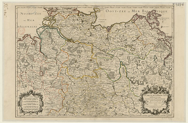
map of the circle of lower saxony by sanson
bibliothèque nationale de france
maps of ports and fortresses of the mediterranean by marco boschini (1651)
palaiokastro
carte de la syrie by guillaume delisle (1764)
bibliothèque nationale de france
bibliothèque nationale de france
cartouches by tomas lópez
carte de l'alsace by sanson (1703)
bibliothèque nationale de france
maps indicating exploration
royal geographical society
antoine-françois tardieu
pierre antoine tardieu
17th-century double hemisphere world maps
mercator 1587 world map
17th-century maps of scotland
maps of islay
maps of circumnavigations of the world
1740s maps of the world
magni ducatus lithuaniae
maps facing west
maps by john cary
1799 maps
fuente de las nereidas by lola mora
classicism
maps of frankfurt (oder) by braun & hogenberg
maps of wittenberg by braun & hogenberg
maps by pieter van der keere
maps by abraham ortelius
chorographia britanniae (1741-1742)
18th-century maps of essex
maps facing east
anton wied
typography
music
typography
music
ornament
heart
ornament
wine
ornament
wine
ornament
wine
ornament
wine
maps by pieter mortier
maps from gallica
maps of ports and fortresses of the mediterranean by marco boschini (1651)
bibliothèque nationale de france
bibliothèque nationale de france
raymond bonheur
alsace-lorraine. carte départementale. moselle, meurthe, bas-rhin, haut-rhin - btv1b85935488
bibliothèque nationale de france
maps of ports and fortresses of the mediterranean by marco boschini (1651)
bibliothèque nationale de france
13501 - 13600 of 16,781
Next page
/ 168


![Lower part of the Bishopric of Munster and the county of Benthem [Bentheim]... / by Mr Sanson,..., 1700](https://cdn.creazilla.com/illustrations/10000336838/lower-part-of-the-bishopric-of-munster-and-the-county-of-benthem-bentheim-by-mr-sanson-1700-sm.webp)


![The Kingdom of Siam with its tributary kingdoms and the islands of Sumatra, Andemaon and the neighboring islands [sic], 1705](https://cdn.creazilla.com/illustrations/10000834338/the-kingdom-of-siam-with-its-tributary-kingdoms-and-the-islands-of-sumatra-andemaon-and-the-neighboring-islands-sic-1705-sm.jpg)


