Log in
All resources
Create a design
4,578 Free Artworks of Scale
bibliothèque nationale de france
marco boschini
maps of the islands of greece by marco boschini (1658)
context files from gallica
maps of ports and fortresses of the mediterranean by marco boschini (1651)
smithsonian libraries
guillaume sanson
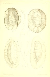
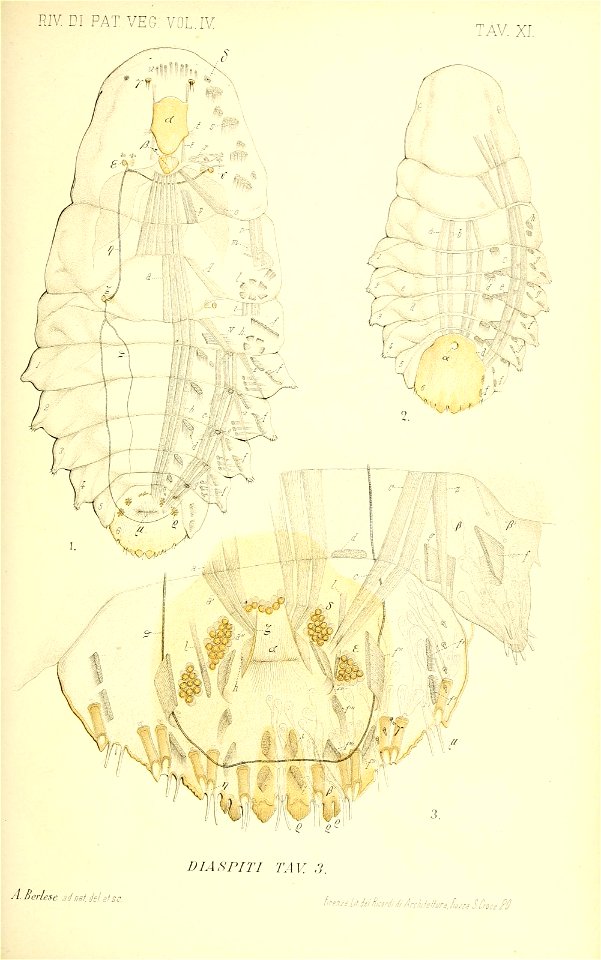
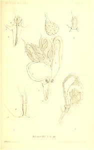
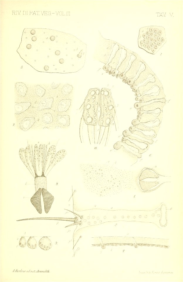
scale insects
bio: insect
le cocciniglie italiane viventi sugli agrumi: pt.1-3 (1893-1896)
old maps of the tyrol
south tyrol
maps of the islands of greece by marco boschini (1658)
history of kythnos
maps of meldorf by braun & hogenberg
maps of heide by braun & hogenberg
maps of the islands of greece by marco boschini (1658)
history of kalymnos
maps of the islands of greece by marco boschini (1658)
history of patmos
maps of the islands of greece by marco boschini (1658)
history of naxos
maps of the islands of greece by marco boschini (1658)
history of paros
maps of the islands of greece by marco boschini (1658)
context files from gallica
maps of ports and fortresses of the mediterranean by marco boschini (1651)
bibliothèque nationale de france
bibliothèque nationale de france
guillaume sanson
maps of ports and fortresses of the mediterranean by marco boschini (1651)
bibliothèque nationale de france
bibliothèque nationale de france
1698 map of evesché de meaux
atlas géographique des quatre parties du monde (delisle)
folded maps
atlas géographique des quatre parties du monde (delisle)
18th-century maps of africa
sanson maps of the circles of germany
bibliothèque nationale de france
atlas géographique des quatre parties du monde (delisle)
maps of paris by guillaume delisle
bibliothèque nationale de france
félix robaut
maps of ports and fortresses of the mediterranean by marco boschini (1651)
bibliothèque nationale de france
bibliothèque nationale de france
guillaume sanson
bibliothèque nationale de france
guillaume sanson
atlas géographique des quatre parties du monde (delisle)
map of italy by guillaume delisle (1700)
eagle
cross
smithsonian libraries
scale insects
smithsonian libraries
scale insects
smithsonian libraries
scale insects
smithsonian libraries
scale insects
captioned scans from das ständebuch
woodcuts of artisans
grenzkarte der preussischen, russischen und oestreichischen monarchien (1796)
maps of mahilioŭ governorate
grenzkarte der preussischen, russischen und oestreichischen monarchien (1796)
sandomierz voivodeship
skulpturenpark lehmbruck-museum duisburg
expressionism
smithsonian libraries
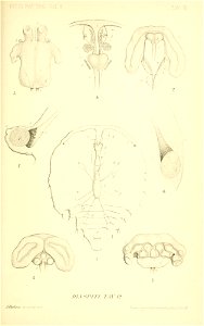
scale insects
smithsonian libraries
scale insects
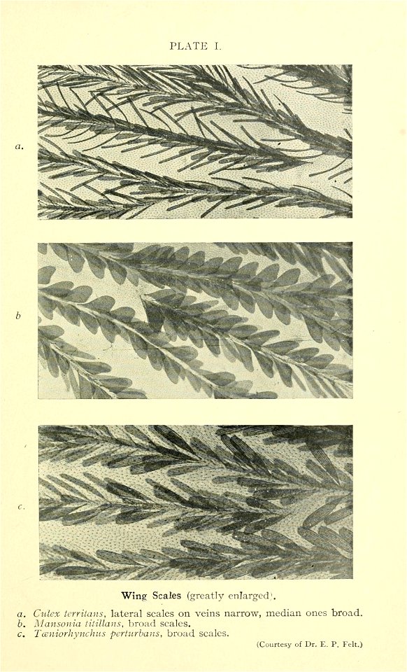
mosquito
insects
maps of peñón de vélez by braun & hogenberg
maps of tunis by braun & hogenberg
1690s maps of greece
maps from gallica
context files from gallica
history of andros
maps of the islands of greece by marco boschini (1658)
history of anafi
context files from gallica
history of amorgos
old hemisphere world maps (partner files)
1800s maps of the world
maps of the islands of greece by marco boschini (1658)
history of ios
map collection of leibniz-institut für länderkunde
1800s maps of the world
old maps of antiparos
old maps of paros
old maps of seville
baroque
maps of the islands of greece by marco boschini (1658)
context files from gallica
maps of the islands of greece by marco boschini (1658)
history of tilos
maps of the islands of greece by marco boschini (1658)
history of leros
bibliothèque nationale de france
guillaume sanson
bibliothèque nationale de france
guillaume sanson
maps of ports and fortresses of the mediterranean by marco boschini (1651)
bibliothèque nationale de france
maps of ports and fortresses of the mediterranean by marco boschini (1651)
bibliothèque nationale de france
maps of ports and fortresses of the mediterranean by marco boschini (1651)
bibliothèque nationale de france
basse partie de l'evesché de munster et le comté de benthem (bentheim)... - par le sr sanson... - btv1b53202442h
guillaume sanson
carte de barbarie, nigritie, guinée par guillaume delisle (1707)
bibliothèque nationale de france
bibliothèque nationale de france
guillaume sanson
atlas géographique des quatre parties du monde (delisle)
folded maps
bibliothèque nationale de france
guillaume sanson
atlas géographique des quatre parties du monde (delisle)
18th-century maps of the world
maps of ports and fortresses of the mediterranean by marco boschini (1651)
old maps of heraklion
maps of the islands of greece by marco boschini (1658)
old maps of the sporades
maps of ports and fortresses of the mediterranean by marco boschini (1651)
bibliothèque nationale de france
abbildung des ohrts iringen und wie selbiger von georg fridrichen margrafen zu baden verschantzet worden, anno 1621 - btv1b53238701j
baroque
maps of cadiz by braun & hogenberg
bibliothèque nationale de france
maps of ports and fortresses of the mediterranean by marco boschini (1651)
bibliothèque nationale de france
map of the circle of franconia by sanson
bibliothèque nationale de france
les duchés de cleves, juliers, limbourg (etc.) by jaillot
bibliothèque nationale de france
cartouches by joseph roux
cartouche (cartography)
maps of ports and fortresses of the mediterranean by marco boschini (1651)
bibliothèque nationale de france
bibliothèque nationale de france
guillaume sanson
maps of ports and fortresses of the mediterranean by marco boschini (1651)
palaiokastro
atlas géographique des quatre parties du monde (delisle)
18th-century maps of france
skulpturenpark lehmbruck-museum duisburg
expressionism
context files from gallica
crete under venetian rule
atlas géographique des quatre parties du monde (delisle)
18th-century double hemisphere world maps
map collection of leibniz-institut für länderkunde
maps of spain by tomas lopez
map collection of leibniz-institut für länderkunde
maps of spain by tomas lopez
checkflicr2
gogapixelai
gigapixel examples
checkflicr2
gigapixel examples
checkflicr2
lerp scales of australian
checkflicr2
biblioteca di storia e cultura del piemonte "giuseppe grosso"
maps of italy
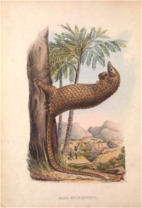
mammals
zoology
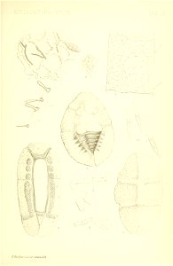
smithsonian libraries
scale insects
smithsonian libraries
scale insects
smithsonian libraries
scale insects
maps of meldorf by braun & hogenberg
maps of heide by braun & hogenberg
maps of the islands of greece by marco boschini (1658)
old maps of amorgos
maps of dordrecht by braun & hogenberg
bibliothèque nationale de france
grenzkarte der preussischen, russischen und oestreichischen monarchien (1796)
maps of podolia governorate
maps of the islands of greece by marco boschini (1658)
old maps of kos
maps of the islands of greece by marco boschini (1658)
old maps of nisyros
a topographical map of the county of berks (1761)
bibliothèque nationale de france
a topographical map of the county of berks (1761)
bibliothèque nationale de france
bibliothèque nationale de france
braun/hogenberg dreizehn orte
maps of budapest by braun & hogenberg
maps of vienna by braun & hogenberg
maps of the islands of greece by marco boschini (1658)
old maps of tilos
maps of ports and fortresses of the mediterranean by marco boschini (1651)
bibliothèque nationale de france
sculptor's studio
maps of alsace by guillaume sanson
1660s maps of baden-württemberg
works after joseph vernet
seascapes
maps of the islands of greece by marco boschini (1658)
old maps of anafi
1401 - 1500 of 4,578
Next page
/ 46


![Map of Belgium / lith. by F[éli]x Robaut, Félix Robaut, 1841](https://cdn.creazilla.com/illustrations/10001323570/map-of-belgium-lith-by-flix-robaut-flix-robaut-1841-md.jpg)


![Hellas seu Graecia universa apud P[ieter] Mortier, 1690](https://cdn.creazilla.com/illustrations/10001021044/hellas-seu-graecia-universa-apud-pieter-mortier-1690-sm.webp)


![Lower part of the Bishopric of Munster and the county of Benthem [Bentheim]... / by Mr Sanson,..., 1700](https://cdn.creazilla.com/illustrations/10000336838/lower-part-of-the-bishopric-of-munster-and-the-county-of-benthem-bentheim-by-mr-sanson-1700-md.jpg)