Log in
All resources
Create a design
38,713 Free Artworks of Map
bibliothèque nationale de france
tresor des cartes geographiques (1659)
beschreibung und contrafactur der vornembster stät der welt, liber primus civitates orbis terrarum
maps
cartography
engraving
chalcography
grabados
fondo antiguo
calcografía
cartography
maps
cartography
maps
cartography
maps
cartography
maps
cartography
maps
1690s maps of greece
maps from gallica
maps of saint paul's journeys
maps by thomas starling
old hemisphere world maps (partner files)
1800s maps of the world
map collection of leibniz-institut für länderkunde
1800s maps of the world
maps of peñón de vélez by braun & hogenberg
maps of tunis by braun & hogenberg
old maps of antiparos
old maps of paros
history of bernkastel-kues
historic views of boppard
gemeente atlas van nederland - south holland
maps of oudewater
maps of cairo by braun & hogenberg
eran laor cartographic collection
old maps of smolensk
baroque
old maps of utrecht (city)
atlas van loon
maps of mexico city by braun & hogenberg
maps of cusco by braun & hogenberg
maps by willem and johannes blaeu
1630s maps of asia
maps of uithuizermeeden
oldenzijl
maps of cairo by braun & hogenberg
ottoman egypt
tresor des cartes geographiques (1659)
old maps of the whole peloponnese
maps of barbary coast by mercator-hondius
tresor des cartes geographiques (1659)
tresor des cartes geographiques (1659)
maps of cyprus by mercator-hondius
carte figurative de l'instruction populaire de la france
maps from gallica
beschreibung und contrafactur der vornembster stät der welt, liber primus civitates orbis terrarum
maps of tours by braun & hogenberg
tresor des cartes geographiques (1659)
17th-century maps of scandinavia
beschreibung und contrafactur der vornembster stät der welt, liber primus civitates orbis terrarum
maps of vienna by braun & hogenberg
beschreibung und contrafactur der vornembster stät der welt, liber primus civitates orbis terrarum
maps of lisbon by braun & hogenberg (1572)
tresor des cartes geographiques (1659)
17th-century celestial maps
beschreibung und contrafactur der vornembster stät der welt, liber primus civitates orbis terrarum
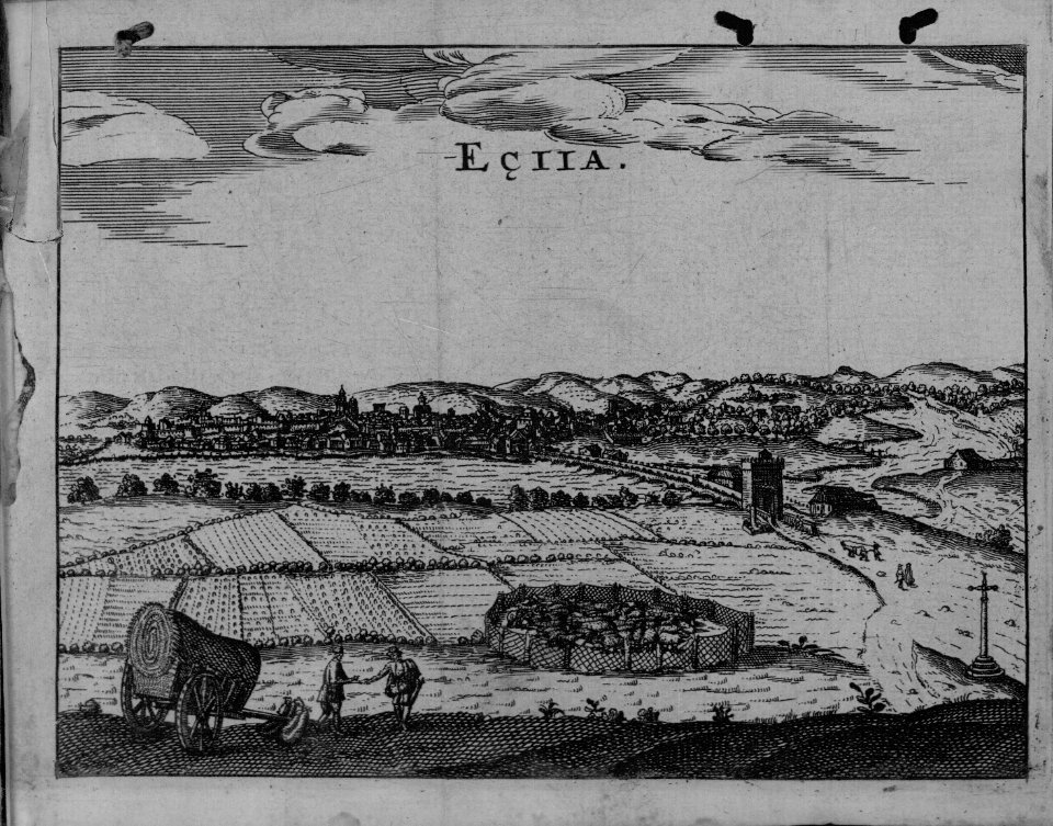
maps of écija by braun & hogenberg
tresor des cartes geographiques (1659)
17th-century maps of morocco
beschreibung und contrafactur der vornembster stät der welt, liber primus civitates orbis terrarum
maps of sion by braun & hogenberg
tresor des cartes geographiques (1659)
17th-century maps of the british isles
bibliothèque nationale de france
maps by thomas kitchin
beschreibung und contrafactur der vornembster stät der welt, liber primus civitates orbis terrarum
maps of dresden by braun & hogenberg
beschreibung und contrafactur der vornembster stät der welt, liber primus civitates orbis terrarum
maps of famagusta by braun & hogenberg
maps of prague by braun & hogenberg
maps of cheb by braun & hogenberg
tresor des cartes geographiques (1659)
1650s maps of the ottoman empire
maps of candia by ortelius and mercator
tresor des cartes geographiques (1659)
beschreibung und contrafactur der vornembster stät der welt, liber primus civitates orbis terrarum
maps of frankfurt (oder) by braun & hogenberg
beschreibung und contrafactur der vornembster stät der welt, liber primus civitates orbis terrarum
maps of lisbon by braun & hogenberg (1572)
17th-century maps of the malay archipelago
tresor des cartes geographiques (1659)
beschreibung und contrafactur der vornembster stät der welt, liber primus civitates orbis terrarum
maps of genoa by braun & hogenberg
tresor des cartes geographiques (1659)
17th-century maps of the arctic
tresor des cartes geographiques (1659)
1650s maps of the iberian peninsula
beschreibung und contrafactur der vornembster stät der welt, liber primus civitates orbis terrarum
maps of burgos by braun & hogenberg
beschreibung und contrafactur der vornembster stät der welt, liber primus civitates orbis terrarum
maps of rouen by braun & hogenberg
tresor des cartes geographiques (1659)
1650s maps of the holy roman empire
beschreibung und contrafactur der vornembster stät der welt, liber primus civitates orbis terrarum
maps of arras by braun & hogenberg
maps of barbary coast by mercator-hondius
tresor des cartes geographiques (1659)
civitates orbis terrarvm, liber primvs (1577)
maps of tours by braun & hogenberg
chorographia britanniae (1741-1742)
18th-century maps of sussex
atlas minor gerardi mercatoris (1609)
maps of asia by mercator-hondius
civitates orbis terrarvm, liber primvs (1577)
maps of groningen by braun & hogenberg
civitates orbis terrarvm, liber primvs (1577)
maps of rouen by braun & hogenberg
panoramic maps of seville by braun & hogenberg
civitates orbis terrarvm, liber primvs (1577)
saint paul island (alaska)
old maps of alaska
maps of ghent by braun & hogenberg
backs of postcards in curt teich postcard archives
1700s maps of the holy roman empire
maps by joachim bormeester
turgot map of paris, kyoto university library – derivative files
couvent des filles-saint-thomas
map of amsterdam by gerrit de broen (ii)
gerrit de broen
1800s maps of the caribbean
charles picquet
maps of goa by braun & hogenberg
old goa
nicolaas samuel crucquius
old maps of delfland
paintings in the rijksmuseum amsterdam
han van meegeren
maps of elmina by braun & hogenberg
elmina in the 1570s
geographia universalis (1545) in the british museum
german renaissance,northern renaissance
old maps of the tyrol
south tyrol
old maps of milos
maps facing east
maps of bordeaux by braun & hogenberg
maps of nîmes by braun & hogenberg
old maps of the tyrol
south tyrol
old maps of the tyrol
south tyrol
maps by willem and johannes blaeu
1663 maps of africa
old maps of amsterdam
hendrik de leth
1710s maps of the world
maps by edward wright
cartography
maps
old maps of finistère
maps from gallica
maps from the earth and its inhabitants, vol. xii
maps from the earth and its inhabitants, vol. v
maps from the earth and its inhabitants, vol. xi
maps from the earth and its inhabitants, vol. xv
maps from the earth and its inhabitants, vol. xvii
1870s maps of the united states
maps from the earth and its inhabitants, vol. iv
maps from the earth and its inhabitants, vol. iv
maps from the earth and its inhabitants, vol. vi
maps from the earth and its inhabitants, vol. xiv
keeling islands
maps from the earth and its inhabitants, vol. xvi
maps from the earth and its inhabitants, vol. v
maps from the earth and its inhabitants, vol. v
maps from the earth and its inhabitants, vol. vi
maps from the earth and its inhabitants, vol. ix
maps from the earth and its inhabitants, vol. ix
maps from the earth and its inhabitants, vol. xvi
maps from the earth and its inhabitants, vol. xvii
maps from the earth and its inhabitants, vol. v
maps from the earth and its inhabitants, vol. ix
maps from the earth and its inhabitants, vol. vi
maps from the earth and its inhabitants, vol. xii
maps from the earth and its inhabitants, vol. xiv
20301 - 20400 of 38,713
Next page
/ 388


![Hellas seu Graecia universa apud P[ieter] Mortier, 1690](https://cdn.creazilla.com/illustrations/10001021044/hellas-seu-graecia-universa-apud-pieter-mortier-1690-md.jpg)


![Treasure of geographical maps of the main states of the universe [...], 1659](https://cdn.creazilla.com/illustrations/10000206928/treasure-of-geographical-maps-of-the-main-states-of-the-universe-1659-md.jpg)
![Treasure of geographical maps of the main states of the universe [...], 1659](https://cdn.creazilla.com/illustrations/10000572901/treasure-of-geographical-maps-of-the-main-states-of-the-universe-1659-md.jpg)
![Treasure of geographical maps of the main states of the universe [...], 1659](https://cdn.creazilla.com/illustrations/10000589616/treasure-of-geographical-maps-of-the-main-states-of-the-universe-1659-sm.webp)

![Beschreibung und Contrafactur der Vornembster stät der Welt, liber primus [Civities of the World], 1574](https://cdn.creazilla.com/illustrations/10000639501/beschreibung-und-contrafactur-der-vornembster-st-t-der-welt-liber-primus-civities-of-the-world-1574-sm.jpg)
![Treasure of geographical maps of the main states of the universe [...], 1659](https://cdn.creazilla.com/illustrations/10000436833/treasure-of-geographical-maps-of-the-main-states-of-the-universe-1659-sm.webp)
![Beschreibung und Contrafactur der Vornembster stät der Welt, liber primus [Civities of the World], 1574](https://cdn.creazilla.com/illustrations/10000691110/beschreibung-und-contrafactur-der-vornembster-st-t-der-welt-liber-primus-civities-of-the-world-1574-sm.jpg)
![Beschreibung und Contrafactur der Vornembster stät der Welt, liber primus [Civities of the World], 1574](https://cdn.creazilla.com/illustrations/10000735975/beschreibung-und-contrafactur-der-vornembster-st-t-der-welt-liber-primus-civities-of-the-world-1574-sm.jpg)
![Treasure of geographical maps of the main states of the universe [...], 1659](https://cdn.creazilla.com/illustrations/10000284064/treasure-of-geographical-maps-of-the-main-states-of-the-universe-1659-md.jpg)
![Beschreibung und Contrafactur der Vornembster stät der Welt, liber primus [Civities of the World], 1574](https://cdn.creazilla.com/illustrations/10000353500/beschreibung-und-contrafactur-der-vornembster-stt-der-welt-liber-primus-civities-of-the-world-1574-sm.webp)
![Treasure of geographical maps of the main states of the universe [...], 1659](https://cdn.creazilla.com/illustrations/10000171002/treasure-of-geographical-maps-of-the-main-states-of-the-universe-1659-sm.webp)
![Beschreibung und Contrafactur der Vornembster stät der Welt, liber primus [Civities of the World], 1574](https://cdn.creazilla.com/illustrations/10000920445/beschreibung-und-contrafactur-der-vornembster-stt-der-welt-liber-primus-civities-of-the-world-1574-sm.webp)
![Treasure of geographical maps of the main states of the universe [...], 1659](https://cdn.creazilla.com/illustrations/10001373480/treasure-of-geographical-maps-of-the-main-states-of-the-universe-1659-sm.jpg)

![Beschreibung und Contrafactur der Vornembster stät der Welt, liber primus [Civities of the World], 1574](https://cdn.creazilla.com/illustrations/10000623896/beschreibung-und-contrafactur-der-vornembster-st-t-der-welt-liber-primus-civities-of-the-world-1574-sm.jpg)
![Beschreibung und Contrafactur der Vornembster stät der Welt, liber primus [Civities of the World], 1574](https://cdn.creazilla.com/illustrations/10000713400/beschreibung-und-contrafactur-der-vornembster-st-t-der-welt-liber-primus-civities-of-the-world-1574-sm.jpg)

![Treasure of geographical maps of the main states of the universe [...], 1659](https://cdn.creazilla.com/illustrations/10000550553/treasure-of-geographical-maps-of-the-main-states-of-the-universe-1659-md.jpg)
![Treasure of geographical maps of the main states of the universe [...], 1659](https://cdn.creazilla.com/illustrations/10000760159/treasure-of-geographical-maps-of-the-main-states-of-the-universe-1659-md.jpg)
![Beschreibung und Contrafactur der Vornembster stät der Welt, liber primus [Civities of the World], 1574](https://cdn.creazilla.com/illustrations/10000573975/beschreibung-und-contrafactur-der-vornembster-st-t-der-welt-liber-primus-civities-of-the-world-1574-sm.jpg)
![Beschreibung und Contrafactur der Vornembster stät der Welt, liber primus [Civities of the World], 1574](https://cdn.creazilla.com/illustrations/10000732110/beschreibung-und-contrafactur-der-vornembster-stt-der-welt-liber-primus-civities-of-the-world-1574-sm.webp)
![Treasure of geographical maps of the main states of the universe [...], 1659](https://cdn.creazilla.com/illustrations/10000757788/treasure-of-geographical-maps-of-the-main-states-of-the-universe-1659-sm.webp)
![Beschreibung und Contrafactur der Vornembster stät der Welt, liber primus [Civities of the World], 1574](https://cdn.creazilla.com/illustrations/10001069444/beschreibung-und-contrafactur-der-vornembster-st-t-der-welt-liber-primus-civities-of-the-world-1574-sm.jpg)
![Treasure of geographical maps of the main states of the universe [...], 1659](https://cdn.creazilla.com/illustrations/10001044907/treasure-of-geographical-maps-of-the-main-states-of-the-universe-1659-md.jpg)
![Treasure of geographical maps of the main states of the universe [...], 1659](https://cdn.creazilla.com/illustrations/10000485227/treasure-of-geographical-maps-of-the-main-states-of-the-universe-1659-sm.jpg)
![Beschreibung und Contrafactur der Vornembster stät der Welt, liber primus [Civities of the World], 1574](https://cdn.creazilla.com/illustrations/10000427645/beschreibung-und-contrafactur-der-vornembster-stt-der-welt-liber-primus-civities-of-the-world-1574-sm.webp)
![Beschreibung und Contrafactur der Vornembster stät der Welt, liber primus [Civities of the World], 1574](https://cdn.creazilla.com/illustrations/10001343706/beschreibung-und-contrafactur-der-vornembster-stt-der-welt-liber-primus-civities-of-the-world-1574-sm.webp)
![Treasure of geographical maps of the main states of the universe [...], 1659](https://cdn.creazilla.com/illustrations/10001567990/treasure-of-geographical-maps-of-the-main-states-of-the-universe-1659-sm.jpg)
![Beschreibung und Contrafactur der Vornembster stät der Welt, liber primus [Civities of the World], 1574](https://cdn.creazilla.com/illustrations/10001574626/beschreibung-und-contrafactur-der-vornembster-stt-der-welt-liber-primus-civities-of-the-world-1574-sm.webp)
![Treasure of geographical maps of the main states of the universe [...], 1659](https://cdn.creazilla.com/illustrations/10001596623/treasure-of-geographical-maps-of-the-main-states-of-the-universe-1659-sm.jpg)


![Aethiopia inferior, vel exterior, partes magis septentrionales, quae hic desiderantur, vide in tabula Aethiopiae superioris / [Joan Blaeu], 1663](https://cdn.creazilla.com/illustrations/10000599277/aethiopia-inferior-vel-exterior-partes-magis-septentrionales-quae-hic-desiderantur-vide-in-tabula-aethiopiae-superioris-joan-blaeu-1663-md.jpg)


