Log in
All resources
Create a design
38,713 Free Artworks of Map
maps from the earth and its inhabitants, vol. iv
maps from the earth and its inhabitants, vol. v
eran laor cartographic collection
maps from the earth and its inhabitants, vol. xviii
maps from the earth and its inhabitants, vol. iii
the comprehensive history of england (1876)
english-language maps showing history
1870s maps showing history
maps from the earth and its inhabitants, vol. xii
latin-language maps
maps from the earth and its inhabitants, vol. iii
population density maps of europe
maps from the earth and its inhabitants, vol. iv
old maps of lindisfarne
maps from the earth and its inhabitants, vol. iv
old maps of the shetland islands
maps from the earth and its inhabitants, vol. vii
old maps of xi'an
1878 maps of europe
augusto grossi
eran laor cartographic collection
nicolaus van aelst
eran laor cartographic collection
pierre aveline
old maps of naples
mannerism
eran laor cartographic collection
pierre françois tardieu
eran laor cartographic collection
isaak tirion
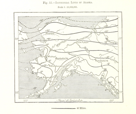
our arctic province, alaska and the seal islands (1886)
old maps of alaska
asia noviter delineata
1617 drawings
the story of geographical discovery
maps from books
illustrations de histoire naturelle - tome i - de seve 1749
1740s maps of the americas
asia noviter delineata
1617 drawings
redeeming the republic (1890)
1890s maps showing history
maps from the earth and its inhabitants, vol. xiv
blitar
maps from the earth and its inhabitants, vol. xviii
llanquihue
atlas maior, vol 3 (germany) - joan blaeu, 1667 - bl 114.h(star).3
johannes gigas
people with maps in art
posters of germany
hamburgische elbkarte von melchior lorichs
melchior lorck
maps of groningen by braun & hogenberg
history of martinikerk (groningen)
maps from the earth and its inhabitants, vol. x
19th-century maps of africa
historisk atlas (stockholm, norstedt & söner, 1880)
maps of 11th-century italy
place du panthéon on maps
rue soufflot (paris)
turgot map of paris – derivative files
hôtel d'armenonville
historical images of macau
asia noviter delineata
maps from the earth and its inhabitants, vol. iv
maps of cheltenham
maps of haussmann's renovation of paris
rue de médicis (paris)
maps of abyssinia by mercator-hondius
curt teich postcard archives
map postcards
matthäus merian der jüngere
great comet of 1680
cartouches by willem and johannes blaeu
joan blaeu
old maps of the tribes of israel
old maps of ancient israel
bibliothèque nationale de france
guillaume sanson
eran laor cartographic collection
richard william seale
eran laor cartographic collection
richard william seale
eran laor cartographic collection
richard william seale
the comprehensive history of england (1876)
english-language maps showing history
the comprehensive history of england (1876)
english-language maps showing history
the comprehensive history of england (1876)
english-language maps showing history
the comprehensive history of england (1876)
danube in 1704
maps in the rijksmuseum amsterdam
1627 maps
maps from the earth and its inhabitants, vol. vi
alay district
the comprehensive history of england (1876)
english-language maps showing history
maps from the earth and its inhabitants, vol. iv
1870s maps of the british isles
maps from the earth and its inhabitants, vol. v
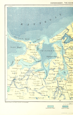
19th-century maps of copenhagen
maps from the earth and its inhabitants, vol. xv
maps of niagara falls, new york
maps from the earth and its inhabitants, vol. xiii
maps of the kingdom of kongo
maps from the earth and its inhabitants, vol. ix
maps of afro-eurasia
maps from the earth and its inhabitants, vol. vii
ethnographic maps of asia
maps from the earth and its inhabitants, vol. xvii
1870s maps of the united states
maps from the earth and its inhabitants, vol. xviii
topographic maps of south america
maps from the earth and its inhabitants, vol. iv
1870s maps of scotland
maps from the earth and its inhabitants, vol. iv
maps of the british isles
maps from the earth and its inhabitants, vol. xviii
19th-century maps of trinidad and tobago
maps from the earth and its inhabitants, vol. xii
old maps of cameroon
maps from the earth and its inhabitants, vol. xi
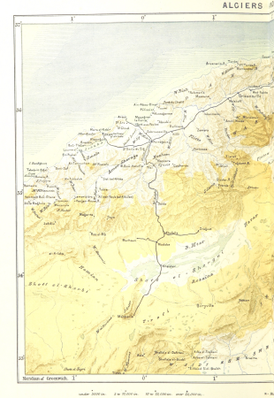
1870s maps of algeria
maps from the earth and its inhabitants, vol. iv
old maps of derby
maps from the earth and its inhabitants, vol. xvi
maps of the history of mexico
maps from the earth and its inhabitants, vol. iii
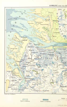
old maps of hamburg
maps from the earth and its inhabitants, vol. iv
19th-century maps of lincolnshire
maps from the earth and its inhabitants, vol. xvi
maps of agriculture in mexico
maps from the earth and its inhabitants, vol. iv
old maps of plymouth and devonport
maps from the earth and its inhabitants, vol. iv
maps of the british isles
maps from the earth and its inhabitants, vol. iv
19th-century maps of cambridgeshire
maps from the earth and its inhabitants, vol. iii
old maps of hamburg
maps from the earth and its inhabitants, vol. v
maps of jan mayen
maps from the earth and its inhabitants, vol. xii
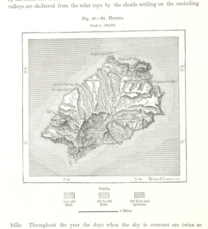
old maps of saint helena
maps from the earth and its inhabitants, vol. xiv
1870s maps of hawaii
maps from the earth and its inhabitants, vol. v
19th-century maps of crimea
maps from the earth and its inhabitants, vol. iv
old maps of hadrian's wall
maps from the earth and its inhabitants, vol. xi
1870s maps of algeria
maps from the earth and its inhabitants, vol. iv
1870s maps of the british isles
maps from the earth and its inhabitants, vol. xvi
population density maps of mexico
maps from the earth and its inhabitants, vol. xiii
maps of the history of south africa
maps from the earth and its inhabitants, vol. xiv
old maps of antarctica
maps from the earth and its inhabitants, vol. iii
19th-century maps of dresden
maps from the earth and its inhabitants, vol. v
old maps of spitsbergen
maps from the earth and its inhabitants, vol. v
19th-century maps of copenhagen
maps from the earth and its inhabitants, vol. xv
climate maps of alaska
maps from the earth and its inhabitants, vol. viii
old maps of kashmir
maps from the earth and its inhabitants, vol. xii
19th-century maps of senegal
maps from the earth and its inhabitants, vol. xi
old maps of tripoli
maps from the earth and its inhabitants, vol. xii
old maps of cameroon
maps from the earth and its inhabitants, vol. v
19th-century maps of saint petersburg
old maps of reaches or the estuary of the river thames
maps from the earth and its inhabitants, vol. iv
maps from the earth and its inhabitants, vol. xii
maps of the congo river
maps from the earth and its inhabitants, vol. vi
bathymetric maps of the caspian sea
maps from the earth and its inhabitants, vol. iii
old maps of rijeka
maps from the earth and its inhabitants, vol. iv
19th-century maps of gloucestershire
maps from the earth and its inhabitants, vol. iv
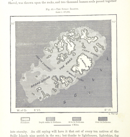
maps of the scilly islands
maps from the earth and its inhabitants, vol. vii
old maps of beijing
maps from the earth and its inhabitants, vol. v
population density maps of europe
maps from the earth and its inhabitants, vol. v
old maps of the black sea
maps from the earth and its inhabitants, vol. xviii
old maps of bogotá
maps from the earth and its inhabitants, vol. xviii
old maps of bogotá
maps from the earth and its inhabitants, vol. xviii
old maps of curaçao
maps from the earth and its inhabitants, vol. xvi
19th-century maps of guadeloupe
maps from the earth and its inhabitants, vol. iv
19th-century maps of lancashire
18501 - 18600 of 38,713
Next page
/ 388