Log in
All resources
Create a design
38,713 Free Artworks of Map
maps of africa
africa in the 1890s
maps from the earth and its inhabitants, vol. xii
john rocque 1746 london map (a1-h3)
john rocque
bibliothèque nationale de france
maps from the earth and its inhabitants, vol. xiii
eran laor cartographic collection
maps from the earth and its inhabitants, vol. xi
english-language maps
eran laor cartographic collection
william hughes (geographer)
eran laor cartographic collection
edward weller
eran laor cartographic collection
william hole (engraver)
eran laor cartographic collection
edward weller
eran laor cartographic collection
alain manesson-mallet
avignon in the 17th century
atlas van loon
john rocque 1746 london map (a1-h3)
john rocque
john rocque 1746 london map (a1-h3)
john rocque
john rocque 1746 london map (a1-h3)
john rocque
john rocque 1746 london map (a1-h3)
john rocque
john rocque 1746 london map (a1-h3)
john rocque
john rocque 1746 london map (a1-h3)
john rocque
old maps of rennes
adolphe périaux
naval battles involving the ottoman empire in art
bombardment of algiers (1783)
maps of portugal by fernando álvares seco
maps by willem and johannes blaeu
old maps of capitanata
maps of beaumont by braun & hogenberg
john rocque 1746 london map (a1-h3)
john rocque
john rocque 1746 london map (a1-h3)
john rocque
john rocque 1746 london map (a1-h3)
john rocque
john rocque 1746 london map (a1-h3)
john rocque
john rocque 1746 london map (a1-h3)
john rocque
john rocque 1746 london map (a1-h3)
john rocque
john rocque 1746 london map (a1-h3)
john rocque
old maps of southeast asia
carolus allard
john rocque 1746 london map (a1-h3)
john rocque
19th-century maps of crimea
g. h. swanston
maps of spain by tomas lopez
1778 maps of spain
maps by emanuel bowen
1740 maps
1750s maps of the caribbean
maps by thomas kitchin
maps of spain by tomas lopez
1778 maps of spain
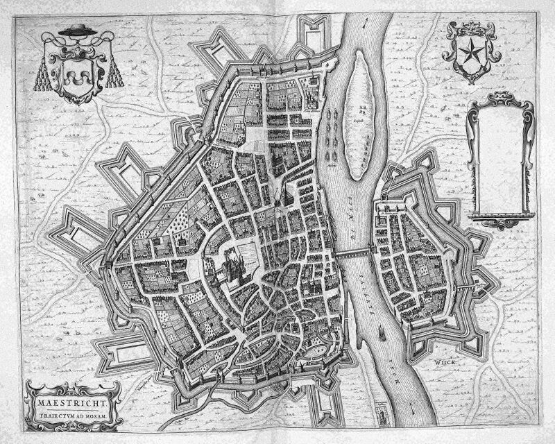
map of maastricht by willem and johannes blaeu (1649)
atlas beudeker
maps by giacomo gastaldi
cornelis de jode
maps from the earth and its inhabitants, vol. xiii
africa in the 1890s
maps from the earth and its inhabitants, vol. xii
africa in the 1890s
maps from the earth and its inhabitants, vol. xii
africa in the 1890s
maps from the earth and its inhabitants, vol. xii
africa in the 1890s
old images of dadra and nagar haveli and daman and diu
maps of diu by braun & hogenberg
maps from the earth and its inhabitants, vol. xii
africa in the 1890s
maps from the earth and its inhabitants, vol. xiii
maps of africa
maps from the earth and its inhabitants, vol. xi
africa in the 1890s
maps from the earth and its inhabitants, vol. xiii
maps of africa
maps from the earth and its inhabitants, vol. xi
africa in the 1880s
maps from the earth and its inhabitants, vol. xii
africa in the 1890s
maps from the earth and its inhabitants, vol. xii
africa in the 1890s
maps from the earth and its inhabitants, vol. xi
africa in the 1890s
maps from the earth and its inhabitants, vol. xii
africa in the 1890s
gemeente atlas van nederland - north holland
maps of beets, north holland
maps from the earth and its inhabitants, vol. xii
africa in the 1890s
maps from the earth and its inhabitants, vol. xii
africa in the 1890s
maps from the earth and its inhabitants, vol. xii
africa in the 1890s
maps from the earth and its inhabitants, vol. xiii
maps of africa
maps from the earth and its inhabitants, vol. xii
africa in the 1890s
maps from the earth and its inhabitants, vol. xiii
africa in the 1890s
maps by giacomo gastaldi
cornelis de jode
maps from the earth and its inhabitants, vol. xiii
africa in the 1890s
maps from the earth and its inhabitants, vol. xi
africa in the 1890s
maps from the earth and its inhabitants, vol. xii
africa in the 1890s
hemispheres centered south pole
manuscript maps
maps from the earth and its inhabitants, vol. xi
africa in the 1890s
maps from the earth and its inhabitants, vol. xii
africa in the 1890s
maps from the earth and its inhabitants, vol. xiii
africa in the 1890s
maps from the earth and its inhabitants, vol. xii
africa in the 1890s
maps from the earth and its inhabitants, vol. xii
africa in the 1890s
maps from the earth and its inhabitants, vol. xiii
africa in the 1890s
old maps of the kingdom of naples
lago patria
1760s maps of the americas
jean janvier
eran laor cartographic collection
édouard hocquart
maps by willem and johannes blaeu
maps made in the 17th century
maps by alexis-hubert jaillot
old maps of toulouse
the dominion of portugal in africa (1889)
maps of cefala by braun & hogenberg
ismailïa. a narrative of the expedition to central africa for the suppression of the slave trade (1874)
nyanza, rwanda
maps from gallica
baroque
maps by willem and johannes blaeu
maps of rügen by eilhard lubinus
cartes de franz schrader
old maps of oran
maps of liège by johannes blaeu - derivative files
couvent des augustins de liège
maps in the library of congress
old city hall (knoxville)
media from regionaal archief alkmaar
zuidschermer
eran laor cartographic collection
joris hoefnagel
maps of dunkerque by braun & hogenberg
maps of bourbourg by braun & hogenberg
plan de roussel - derivative files
château de bercy
heresies of sea power (fred t. jane)
telecoupling
maps of tübingen by braun & hogenberg
maps of eisleben by braun & hogenberg
map of maastricht by willem and johannes blaeu (1649)
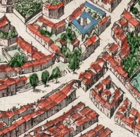
nieuwstad fortifications (maastricht)
maps by petrus schenk
adorf/vogtl.
turgot map of paris – derivative files
boulevard saint-denis (paris)
chorographia britanniae (1741-1742)
18th-century maps of kent
chorographia britanniae (1741-1742)
18th-century maps of cornwall
de praecipvis totivs vniversi vrbibvs, liber secvndvs (1575)
maps of dunkerque by braun & hogenberg
maps of mexico by mercator-hondius
maps of the island of korčula
gustav freytag (cartographer)
gallery of geographical maps (vatican museums)
fucine plain
maps of wales by humphrey llwyd
accuratissima sliae fluminis descriptio
maps by johannes mejer
carta hydrographica y chorographica de las yslas filipinas
baroque painting
hamburg in topographia saxoniae inferioris (merian)
baroque
eran laor cartographic collection
tranquillo mollo
maps by thomas nast
1872 maps of texas
maps from the earth and its inhabitants, vol. xii
africa in the 1890s
maps from the earth and its inhabitants, vol. xiii
maps of africa
17201 - 17300 of 38,713
Next page
/ 388


![Dvynkercke; Greveling; Borborch / [Georg Braun]](https://cdn.creazilla.com/illustrations/10000705529/dvynkercke-greveling-borborch-georg-braun-md.jpg)


