Log in
All resources
Create a design
38,713 Free Artworks of Map
africa in the 1890s
maps of africa
gemeente atlas van nederland - north holland
1860s maps of north holland
maps from the earth and its inhabitants, vol. xiii
maps from the earth and its inhabitants, vol. xii
maps by willem and johannes blaeu
eran laor cartographic collection
bibliothèque nationale de france
ateliers bmb mercator
gemeente atlas van nederland - north holland
maps of westzaan
topographia bohemiae moraviae et silesiae (merian)
baroque
maps from the earth and its inhabitants, vol. xii
africa in the 1890s
gemeente atlas van nederland - north holland
maps of wijdewormer
gemeente atlas van nederland - north holland
maps of midwoud
maps of the battle of perryville
memoirs of henry villard
maps of polders in zeeland
old maps of sluis
gemeente atlas van nederland - north holland
maps of twisk
gemeente atlas van nederland - north holland
maps of urk
maps from the earth and its inhabitants, vol. xii
africa in the 1890s
maps from the earth and its inhabitants, vol. xiii
maps of africa
gemeente atlas van nederland - north holland
maps of vlieland
maps from the earth and its inhabitants, vol. xiii
africa in the 1890s
gemeente atlas van nederland - north holland
maps of westwoud
châlons-en-champagne in the 17th century
hugues picart
maps by willem and johannes blaeu
17th-century maps of the world
1777 maps of south america
maps by thomas kitchin
maps of south scotland by gerardus mercator
ateliers bmb mercator
gemeente atlas van nederland - north holland
maps of wormerveer
maps by willem and johannes blaeu
maps of montfoort
gemeente atlas van nederland - north holland
maps of warder
16th-century maps of istanbul
david kandel
gemeente atlas van nederland - north holland
maps of hoogwoud
gemeente atlas van nederland - north holland
maps of ilpendam
gemeente atlas van nederland - north holland
maps of middelie
maps from the earth and its inhabitants, vol. xi
africa in the 1890s
maps by giacomo gastaldi
cornelis de jode
gemeente atlas van nederland - north holland
maps of opperdoes
gemeente atlas van nederland - north holland
maps of bovenkarspel
maps from the earth and its inhabitants, vol. xi
africa in the 1890s
gemeente atlas van nederland - north holland
maps of opmeer
maps from the earth and its inhabitants, vol. xi
africa in the 1890s
maps from the earth and its inhabitants, vol. xi
africa in the 1890s
gemeente atlas van nederland - north holland
maps of wormer
gemeente atlas van nederland - north holland
maps of oosthuizen
maps from the earth and its inhabitants, vol. xiii
maps of africa
maps from the earth and its inhabitants, vol. xiii
maps of africa
maps from the earth and its inhabitants, vol. xiii
africa in the 1890s
gemeente atlas van nederland - north holland
maps of uitgeest
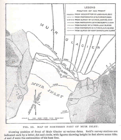
glaciers and glaciation (1910)
maps of muir glacier
asia noviter delineata
1617 drawings
maps made in the 17th century
lazio
terrae sanctae tabula by guillaume delisle (1763)
eran laor cartographic collection
maps of haarlemmerhout
old maps of haarlem
maps of haarlemmerhout
old maps of haarlem
the columbian magazine (1789)
pre-raphaelite brotherhood
the worst journey in the world (1922, cherry-garrard)/volume 1
the worst journey in the world (1922, cherry-garrard)
maps in the library of congress
1753 maps
john rocque's 1748 map of london and adjacent country
maps in the british museum
maps of frankfurt (main) by braun & hogenberg
eran laor cartographic collection
gemeente atlas van nederland - gelderland
varsseveld
maps of schwäbisch hall by braun & hogenberg
eran laor cartographic collection
maps from the earth and its inhabitants, vol. xii
africa in the 1890s
maps from the earth and its inhabitants, vol. xiii
africa in the 1890s
chicago and the midwest, newberry library
1931 maps
maps by willem and johannes blaeu
details of old maps
synopsis universae philologiae
1741 maps of asia
travels in the interior of north america, during the years 1832–1834
works by maximilian zu wied-neuwied
1807 maps of south america
maps by john cary
cartes de franz schrader
old maps of kolkata
maps of county armagh
1760s maps of ireland
geographia universalis (1545) in the british museum
german renaissance,northern renaissance
geographia universalis (1545) in the british museum
german renaissance,northern renaissance
maps of wales by humphrey llwyd
maps by hendrik hondius the younger
cartouches by jan janssonius
maps by willem and johannes blaeu
old maps of aardenburg
from edinburgh to the antarctic. an artist's notes and sketches during the dundee antarctic expedition of 1892-93
expedition maps
maps by willem and johannes blaeu
17th-century maps of sumatra
cartography
maps
maps by willem and johannes blaeu
maps of gelderland
abbaye de longchamp
bac de suresnes
galleria delle carte geografiche - ceiling
paintings of saint paul
maps of europe by mercator-hondius
ateliers bmb mercator
maps of africa by rumold mercator
ateliers bmb mercator
maps of asia by gerardus mercator
ateliers bmb mercator
eran laor cartographic collection
guillaume sanson
map of the circle of austria by sanson
1700s maps of austria
eran laor cartographic collection
jean-claude richard de saint-non
maps in the library of congress
plaine de grenelle
maps of ports and fortresses of the mediterranean by marco boschini (1651)
old maps of souda (crete)
maps from the mechanical curator collection
balaton albuma (1851) by szerelmey
maps of iceland by gerardus mercator
ateliers bmb mercator
gerardi mercatoris atlantis novi. pars tetria (1638)
17th-century maps of lombardy
maps of bremen by braun & hogenberg
marketplace of bremen
aerial views of amherst, massachusetts
town maps by l. r. burleigh
picturesque tour from geneva to milan, by way of the simplon (1820)
maps from the mechanical curator collection
maps from the earth and its inhabitants, vol. xii
africa in the 1890s
plan de roussel - derivative files
proletarian literature
maps from the earth and its inhabitants, vol. xii
africa in the 1890s
africa and its inhabitants, vol. ii
charles eugène perron
maps from the earth and its inhabitants, vol. xii
africa in the 1890s
maps from the earth and its inhabitants, vol. xiii
africa in the 1890s
maps from the earth and its inhabitants, vol. xiii
africa in the 1890s
old maps of dutch brazil
recife in the 1660s
eran laor cartographic collection
caspar merian
curt teich postcard archives
postcard collecting
maps from the earth and its inhabitants, vol. xii
africa in the 1890s
diagrams of krkonoše mute signs
němé značky krkonoš
maps in the library of congress
1776 maps of new jersey
maps by willem and johannes blaeu
1635 maps of ukraine
16901 - 17000 of 38,713
Next page
/ 388


![Port and Forte[z]za d[ell]a Suda / by Marco Boschini, Marco Boschini, 1651](https://cdn.creazilla.com/illustrations/10001359456/port-and-fortezza-della-suda-by-marco-boschini-marco-boschini-1651-sm.webp)


