Log in
All resources
Create a design
38,713 Free Artworks of Map
bibliothèque nationale de france
maps in the library of congress
the comprehensive history of england (1876)
english-language maps showing history
1870s maps showing history
map - museu antônio parreiras
antônio parreiras
zehn karten und ansichten den schlachtfelden des amerikanischen unabhängigkeitskreiges in den staaten pennsylvanien und new york
paintings of battles of the american revolutionary war
eran laor cartographic collection
zehn karten und ansichten den schlachtfelden des amerikanischen unabhängigkeitskreiges in den staaten pennsylvanien und new york
maps in the library of congress
zehn karten und ansichten den schlachtfelden des amerikanischen unabhängigkeitskreiges in den staaten pennsylvanien und new york
maps in the library of congress
maps in the library of congress
cartes et plans de l'amerique
map of italy by guillaume delisle (1700)
1700s maps of italy
1770s maps of the americas
maps by tomas lopez
truscott map of st-petersburg 1753
ivan sokolov
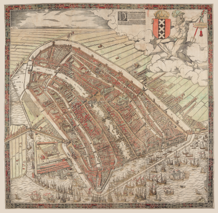
map of amsterdam, 1544
british library
frederic louis norden
maps of nubia
map of brugse vrije by pieter claeissens de jonge
pieter claeissens
the cruise of the marchesa (1889)
19th-century maps of borneo
gemeente atlas van nederland - drenthe
maps of borger-odoorn
cartouches by tomas lópez
tomás lópez
old maps of oldenzaal
atlas van loon
eran laor cartographic collection
francesco valegio
1810s maps of the iberian peninsula
1813 maps of spain
maps from the earth and its inhabitants, vol. iv
old maps of the lake district
maps in the library of congress
1776 maps of new jersey
demolished churches in de barbari map
san stin (venice)
old maps of delft
atlas van loon
1800s maps of the netherlands
evert maaskamp
maps by jacques chiquet
1719 maps of africa
drawings in the museu antônio parreiras
paper and graphite
reconstructions of old maps
german renaissance
maps in the staats- und universitätsbibliothek hamburg
1870 maps of hamburg
atlas geographico del reyno de españa e islas adjacentes (1757)
1757 maps of spain
old maps of capitanata
puglia settentrionale
drawings in the museu antônio parreiras
paper and charcoal
drawings in the museu antônio parreiras
paper and graphite
drawings in the museu antônio parreiras
paper and graphite
andalusia in the 1610s
francisco heylan
eran laor cartographic collection
willem blaeu
1570s maps of africa
1570s maps of egypt
maps of paris from paris musées
baroque
turgot map of paris, david rumsey historical map collection – derivative files
historical images of the hôtel des invalides
inspection générale des carrières
maps from gallica
claes jansz. visscher (ii)
leo belgicus
the comprehensive history of england (1876)
english-language maps showing history
the comprehensive history of england (1876)
english-language maps showing history
the comprehensive history of england (1876)
english-language maps showing history
the comprehensive history of england (1876)
english-language maps showing history
the comprehensive history of england (1876)
english-language maps showing history
topographischer atlas der schweiz
maps of the canton of valais
maps of amersfoort by braun & hogenberg
rce suggested: stadsplattegrond
maps of los palacios by braun & hogenberg
maps of las cabezas by braun & hogenberg
old maps of the sinai peninsula
1870s maps of palestine
maps from university of amsterdam special collections
atlas der neederlanden
maps in the british museum
old maps of leeds
maps of french flanders
atlas van loon
17th-century maps of crete
old maps of candia
landais & oberthur
maps from gallica
pacific ocean in art
ships on maps
bibliothèque municipale de reims, rès. g 152
old maps of abbeville
old maps of the batavian republic
cornelis van baarsel
fatland (audubon, pennsylvania)
valley forge
1640s maps of lower saxony
atlas novus (blaeu)
maps by nicolas sanson
1650s maps of asia
sanson maps of the netherlands
cartouches by sanson family
old maps of dutch brazil
recife in the 1660s
zehn karten und ansichten den schlachtfelden des amerikanischen unabhängigkeitskreiges in den staaten pennsylvanien und new york
maps in the library of congress
17th-century maps of africa
maps from gallica
nouvelle géographie universelle, vol. xii
charles eugène perron
nouvelle géographie universelle, vol. xii
charles eugène perron
heriot row, edinburgh
maps of edinburgh
buildings in wilhelma zoo
schloss rosenstein
coats of arms on maps
1645 maps of belgium
zehn karten und ansichten den schlachtfelden des amerikanischen unabhängigkeitskreiges in den staaten pennsylvanien und new york
maps in the library of congress
hamburgische elbkarte von melchior lorichs
parts of old maps of hamburg
1770s maps of the americas
maps by tomas lopez
a voyage to abyssinia, and travels into the interior of that country, executed under the orders of the british government in the years 1809 & 1810
john outhett
johann friedrich walther
1738 in berlin-mitte
maps in the rijksmuseum amsterdam
18th-century maps of japan
joan blaeu
1648 maps
brazilian paintings in the museu antônio parreiras
luiz christophe
engravings of topographia superioris saxoniae, thüringiae, misniae et lusatiae (merian)
baroque
collections of the blanton museum of art
maps by alexis-hubert jaillot
roman catholic archdiocese of salzburg
old maps of salzburg (state)
maps of liège by johannes blaeu
henry constable
the turkish empire in europe, asia and africa (1752)
maps of the history of turkey
old maps of veliky novgorod
maps of velikiy novgorod
details of old maps, defaced
old maps of samsun
the turkish empire in europe, asia and africa (1752)
old maps of baghdad
vrbivm praecipvarvm totivs mvndi (1612)
maps of oberwesel by braun & hogenberg
17th-century maps of the mediterranean sea
maps in the library of congress
maps of chalon-sur-saône by braun & hogenberg
vrbivm praecipvarvm totivs mvndi (1612)
vrbivm praecipvarvm totivs mvndi (1612)
maps of lauingen by braun & hogenberg
maps of amersfoort by braun & hogenberg
rce suggested: stadsplattegrond
bodleian maps collection
pictorial maps
the comprehensive history of england (1876)
english-language maps showing history
maps from the earth and its inhabitants, vol. vii
treaty ports
eran laor cartographic collection
willem blaeu
maps in the library of congress
pont-aven school
düsseldorf in the 1800s
old maps of düsseldorf
maps by thomas kitchin
old maps of scotland
turgot map of paris, david rumsey historical map collection – derivative files
historical images of bièvre river in paris
old maps of the british empire
illustrations by walter crane
old maps of astypalaia
giacomo franco
maps of mysore
edward weller
maps in the library of congress
1771 maps of north america
charles william meredith van de velde
eran laor cartographic collection
kolk (rotterdam)
baroque
16301 - 16400 of 38,713
Next page
/ 388

![[Ten maps and views of the battlefields of the American Revolutionary War in the states of Pennsylvania and New York], 1777](https://cdn.creazilla.com/illustrations/10000597684/ten-maps-and-views-of-the-battlefields-of-the-american-revolutionary-war-in-the-states-of-pennsylvania-and-new-york-1777-md.jpg)
![[Ten maps and views of the battlefields of the American Revolutionary War in the states of Pennsylvania and New York], 1777](https://cdn.creazilla.com/illustrations/10001450663/ten-maps-and-views-of-the-battlefields-of-the-american-revolutionary-war-in-the-states-of-pennsylvania-and-new-york-1777-md.jpg)


![[Reproduction of the terrestrial globe (orbis imago) by Jean Stabius, 1515] (Facsimile reproduction)](https://cdn.creazilla.com/illustrations/10000450806/reproduction-of-the-terrestrial-globe-orbis-imago-by-jean-stabius-1515-facsimile-reproduction-sm.jpg)


![Topographic map of the south-western slope of Menez-haut / surveyed and drawn up [...] by AM Kamelin, 1849](https://cdn.creazilla.com/illustrations/10001387383/topographic-map-of-the-south-western-slope-of-menez-haut-surveyed-and-drawn-up-by-am-kamelin-1849-md.jpg)


![[Ten maps and views of the battlefields of the American Revolutionary War in the states of Pennsylvania and New York], 1777](https://cdn.creazilla.com/illustrations/10000506393/ten-maps-and-views-of-the-battlefields-of-the-american-revolutionary-war-in-the-states-of-pennsylvania-and-new-york-1777-md.jpg)


![[Ten maps and views of the battlefields of the American Revolutionary War in the states of Pennsylvania and New York], 1777](https://cdn.creazilla.com/illustrations/10000887733/ten-maps-and-views-of-the-battlefields-of-the-american-revolutionary-war-in-the-states-of-pennsylvania-and-new-york-1777-md.jpg)


![[Area of the Dux Daciae Ripensis.], 1436](https://cdn.creazilla.com/illustrations/10000704206/area-of-the-dux-daciae-ripensis-1436-sm.webp)


