Log in
All resources
Create a design
38,713 Free Artworks of Map
bibliothèque nationale de france
maps of spain by tomas lopez
eran laor cartographic collection
old maps of castile and león
maps in the library of congress
maps by willem and johannes blaeu
french-language maps
1779 maps of spain
maps from the earth and its inhabitants, vol. iv
map - museu antônio parreiras
synopsis universae philologiae
1746 maps of europe
arnold van langren map of southwest africa
1600 maps of africa
maps in the library of congress
1721 maps
maps from the earth and its inhabitants, vol. ix
maps of telegraph lines
old maps of south africa
maps of the great trek
maps from the earth and its inhabitants, vol. iv
maps of portland, england
maps from the earth and its inhabitants, vol. xv
maps indicating exploration
maps of rivers of senegal
bafing river
maps from the earth and its inhabitants, vol. x
19th-century maps of egypt
maps by willem and johannes blaeu
1630s maps of the world
gemeente atlas van nederland - south holland
1860s maps of south holland
maps in the library of congress
1889 maps of new york (state)
maps by johannes vingboons
old maps of asia
maps in the british museum
maps by john speed
1610s maps of the holy roman empire
jacques surhon
new york and brooklyn, with jersey city and hoboken water front
maps in the library of congress
clifton (bristol ward)
old maps of clifton
atlas maior, vol 3 (germany) - joan blaeu, 1667 - bl 114.h(star).3
johannes gigas
atlas maior, vol 3 (germany) - joan blaeu, 1667 - bl 114.h(star).3
johannes gigas
clifton (bristol ward)
old maps of clifton
eran laor cartographic collection
elias baeck
eran laor cartographic collection
joseph goupy
parts of old maps of berlin
maps of berlin-mitte
gemeente atlas van nederland - overijssel
netherlands in the 1860s
maps of aire-sur-la-lys city walls
old maps of aire-sur-la-lys
gemeente atlas van nederland - friesland
old maps of leeuwarden
18th-century maps of north africa
maps by tomas lopez
historical maps of the county of kłodzko
coats of arms of county of kladsko
maps of the malay archipelago by mercator-hondius
old maps of castilla la nueva
1765 maps of spain
drawings in the museu antônio parreiras
paper and graphite
drawings in the museu antônio parreiras
paper and graphite
beschreibung der städt der welt - braun & hogenberg - btv1b52512111k
panoramic maps of seville by braun & hogenberg
historisk atlas (stockholm, norstedt & söner, 1880)
maps of the history of asia
maps from the earth and its inhabitants, vol. x
maps of ancient nubia
1858 van de velde maps of palestine and jerusalem
1858 van de velde maps of palestine and jerusalem
1858 van de velde maps of palestine and jerusalem
1858 van de velde maps of palestine and jerusalem
a map of the british empire in america with the french and spanish settlements adjacent thereto
maps in the library of congress
beschreibung der städt der welt - braun & hogenberg - btv1b52512111k
maps of tunis by braun & hogenberg
beschreibung und contrafactur der vornembster stät der welt, liber primus civitates orbis terrarum
panoramic maps of seville by braun & hogenberg
beschreibung der städt der welt - braun & hogenberg - btv1b52512111k
maps of münster (westfalen) by braun & hogenberg
maps of chimay by braun & hogenberg
maps of chimay city walls
the cruise of the alice may in the gulf of st. lawrence and adjacent waters (1885) by benjamin
maps from the mechanical curator collection
maps from the earth and its inhabitants, vol. vii
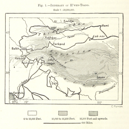
maps of xuanzang's travels
maps from the earth and its inhabitants, vol. iv
maps of loch fyne
maps from the earth and its inhabitants, vol. vii
maps of the yellow river
maps from the earth and its inhabitants, vol. xiii
ethnographic maps of africa
maps from the earth and its inhabitants, vol. iv
mouth of tay
maps from the earth and its inhabitants, vol. xi
maps indicating exploration
maps from the earth and its inhabitants, vol. iv
maps of kirkwall
maps from the earth and its inhabitants, vol. xii
maps of icebergs
maps of the western cape
breede river
gemeente atlas van nederland - south holland
1860s maps of south holland
flemish 18th-century prints in the rijksmuseum amsterdam
maps of ghent by e.h. fricx
map of bruges by marcus gheeraerts (i)
synopsis universae philologiae
1746 maps of asia
fra mauro map derivative works
maps in the library of congress
1758 maps of cuba
landais & oberthur
maps from gallica
topographia westphaliae (merian)
baroque
eran laor cartographic collection
rémy hausermann
maps from the earth and its inhabitants, vol. viii
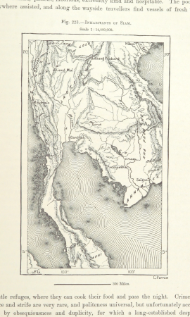
demographic maps of thailand
maps by willem and johannes blaeu
old maps of enkhuizen
maps by willem and johannes blaeu
old maps of gouda
paintings by antônio parreiras in the museu antônio parreiras
paul et virginie
paintings by antônio parreiras in the museu antônio parreiras
1910s paintings by antônio parreiras
maps by willem and johannes blaeu
laurens reael
vrbivm praecipvarvm totivs mvndi liber tertivs (1616)
maps of fortress of charlemont by braun & hogenberg
peregrinatio in terram sanctam (reuwich, 1486, latin)
1486 illustrations
collections of the national library of israel
1725 maps
maps from the earth and its inhabitants, vol. xii
africa in the 1890s
turgot map of paris, university of wisconsin-milwaukee libraries
sheet 7 of the turgot map of paris
18th-century maps of berkshire
britannia depicta
old maps of montana
julius bien
nouvel atlas de la chine
claas condet
1780s maps of the world
german renaissance
plans of central cemetery in sanok
maps of sanok
camps topographiques de la campagne de mdcclvii, en westphalie
stöcken (hannover)
eran laor cartographic collection
joseph goupy
eran laor cartographic collection
joseph goupy
maps of spain by tomas lopez
1779 maps of spain
maps of spain by tomas lopez
1773 maps of spain
maps of spain by tomas lopez
1773 maps of spain
maps of spain by tomas lopez
1779 maps of spain
maps of ancient italy by philipp clüver
eran laor cartographic collection
maps of landgraaf
rimburg
eran laor cartographic collection
afbeeldinge der stad jerusalem
lucas janszoon waghenaer
1584 maps of norway
maps from university of amsterdam special collections
atlas der neederlanden
old maps of westphalia
bindenschild
1620s maps of the iberian peninsula
maps by willem and johannes blaeu
maps of spain by tomas lopez
1782 maps of spain
maps in the british museum
1780s maps of france
old maps of tenerife
1779 maps of spain
maps of spain by tomas lopez
1779 maps of spain
maps of spain by tomas lopez
1782 maps of spain
maps of spain by tomas lopez
1779 maps of spain
illustrations by true williams
roughing it (1872)
15201 - 15300 of 38,713
Next page
/ 388


![Beschreibung und Contrafactur der Vornembster stät der Welt, liber primus [Civities of the World], 1574](https://cdn.creazilla.com/illustrations/10000773749/beschreibung-und-contrafactur-der-vornembster-st-t-der-welt-liber-primus-civities-of-the-world-1574-sm.jpg)