Log in
All resources
Create a design
31,131 Free Images of Subject
bibliothèque nationale de france
maps of spain by tomas lopez
de zegepraalende vecht, vertoonende verscheidene gesichten van lustplaatsen, heeren huysen en dorpen; beginnende van uitrecht en met muyden besluytende. - btv1b532126488
old maps of castile and león
topographisch, oeconomisch und militaerische charte von mecklenburg, schwerin und ratzeburg
topographisch, oeconomisch und militaerische charte des herzogthums mecklenburg schwerin and des fürstenthums ratzeburg - schmettau
guillaume sanson
1779 maps of spain
laid paper
yale center for british art
dutch golden age painting
fur in art by rembrandt
old maps of the bay of gibraltar
18th-century maps of gibraltar
maps by pieter van der keere
1600s maps of norway
male portrait paintings by gilbert stuart
neoclassicism
leonardo's sketches and models for mona lisa
high renaissance,renaissance
etchings of horses
dirk maas
cartes generales de toutes les parties du monde (1658)
maps by guillaume sanson
tinted lithographs in the british museum
lemercier & cie.
old maps of norway
guillaume sanson
maps of spain by tomas lopez
1779 maps of spain
drawings in the yale center for british art
drawings by paul sandby
maps of alsace by guillaume sanson
1690s maps of baden-württemberg
cartes generales de toutes les parties du monde (1658)
1650s maps of saxony
drawings by paul sandby
drawers at work in art
history of montpellier
jacques-jean barre
maps of spain by tomas lopez
1782 maps of spain
maps of spain by tomas lopez
1774 maps of spain
maps of spain by tomas lopez
1774 maps of spain
maps of spain by tomas lopez
1782 maps of spain
maps of spain by tomas lopez
1779 maps of spain
maps of spain by tomas lopez
1779 maps of spain
1780s maps of the caribbean
maps by tomas lopez
1780s maps of the caribbean
maps by tomas lopez
maps of alsace by guillaume sanson
1690s maps of baden-württemberg
maps of bernkastel-kues by braun & hogenberg
maps of zell (mosel) by braun & hogenberg
old maps of tenerife
1779 maps of spain
1770s maps of algeria
maps by tomas lopez
maps of spain by tomas lopez
1779 maps of spain
maps of 's-hertogenbosch by braun & hogenberg
maps of leuven by braun & hogenberg
maps of spain by tomas lopez
1774 maps of spain
maps of spain by tomas lopez
1774 maps of spain
surgeons from the united kingdom
neoclassicism
romanticism,fairy painting
portraits of artists
maps from gallica
1670 maps of asia
venezuela cum parte australi novae andalusiae - btv1b8596473x
maps by hendrik hondius the younger
drawings by thomas rowlandson in the yale center for british art
romanticism
maps of goa by braun & hogenberg
maps of diu by braun & hogenberg
maps of kozhikode by braun & hogenberg
maps of elmina by braun & hogenberg
17th-century maps of luxembourg
maps by pieter van der keere
maps of philippeville by braun & hogenberg
maps of mariembourg by braun & hogenberg
maps of franconia by gerardus mercator
1640s maps of bavaria
drawings by thomas rowlandson in the yale center for british art
romanticism
old maps of westphalia
johannes gigas
panoramic maps of seville by braun & hogenberg
1635 in andalusia
maps by willem and johannes blaeu
robert gordon of straloch
academic art,symbolism
star lore of all ages
engraved portraits of politicians
thomas jefferson in art
historical
history
historical
history
de zegepraalende vecht, vertoonende verscheidene gesichten van lustplaatsen, heeren huysen en dorpen; beginnende van uitrecht en met muyden besluytende. - btv1b532126488
bibliothèque nationale de france
de zegepraalende vecht, vertoonende verscheidene gesichten van lustplaatsen, heeren huysen en dorpen; beginnende van uitrecht en met muyden besluytende. - btv1b532126488
bibliothèque nationale de france
de zegepraalende vecht, vertoonende verscheidene gesichten van lustplaatsen, heeren huysen en dorpen; beginnende van uitrecht en met muyden besluytende. - btv1b532126488
bibliothèque nationale de france
topographisch, oeconomisch und militaerische charte des herzogthums mecklenburg schwerin and des fürstenthums ratzeburg - schmettau
topographisch, oeconomisch und militaerische charte von mecklenburg, schwerin und ratzeburg
bibliothèque nationale de france
cartouches by tomas lópez
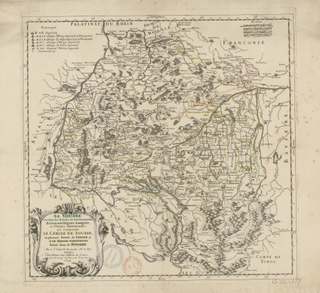
map of the circle of swabia by sanson
bibliothèque nationale de france
bibliothèque nationale de france
cartouches by tomas lópez
vue de l'observatoire de paris - btv1b53181655w
gérard jean-baptiste scotin ii
maps from gallica
baroque
topographisch, oeconomisch und militaerische charte des herzogthums mecklenburg schwerin and des fürstenthums ratzeburg - schmettau
topographisch, oeconomisch und militaerische charte von mecklenburg, schwerin und ratzeburg
carte de partie de lithuanie (west belarus, brest) by nicolas sanson
cartouches by sanson family
maps by louis brion de la tour
1782 maps of the caribbean
maps by louis brion de la tour
1775 maps of asia
topographisch, oeconomisch und militaerische charte des herzogthums mecklenburg schwerin and des fürstenthums ratzeburg - schmettau
topographisch, oeconomisch und militaerische charte von mecklenburg, schwerin und ratzeburg
les plus belles maisons de paris (krafft & ransonnette)
église saint-philippe-du-roule
de zegepraalende vecht, vertoonende verscheidene gesichten van lustplaatsen, heeren huysen en dorpen; beginnende van uitrecht en met muyden besluytende. - btv1b532126488
bibliothèque nationale de france
topographisch, oeconomisch und militaerische charte des herzogthums mecklenburg schwerin and des fürstenthums ratzeburg - schmettau
topographisch, oeconomisch und militaerische charte von mecklenburg, schwerin und ratzeburg
le royaume de hongrie et les estats qui ont esté unis à sa couronne - par le sr jaillot... - btv1b53088629k
guillaume sanson
topographisch, oeconomisch und militaerische charte des herzogthums mecklenburg schwerin and des fürstenthums ratzeburg - schmettau
topographisch, oeconomisch und militaerische charte von mecklenburg, schwerin und ratzeburg
topographisch, oeconomisch und militaerische charte des herzogthums mecklenburg schwerin and des fürstenthums ratzeburg - schmettau
topographisch, oeconomisch und militaerische charte von mecklenburg, schwerin und ratzeburg
de zegepraalende vecht, vertoonende verscheidene gesichten van lustplaatsen, heeren huysen en dorpen; beginnende van uitrecht en met muyden besluytende. - btv1b532126488
bibliothèque nationale de france
de zegepraalende vecht, vertoonende verscheidene gesichten van lustplaatsen, heeren huysen en dorpen; beginnende van uitrecht en met muyden besluytende. - btv1b532126488
bibliothèque nationale de france
topographisch, oeconomisch und militaerische charte des herzogthums mecklenburg schwerin and des fürstenthums ratzeburg - schmettau
topographisch, oeconomisch und militaerische charte von mecklenburg, schwerin und ratzeburg
1782 maps of the caribbean
maps by juan lopez
cartouches by alexis-hubert jaillot
bibliothèque nationale de france
de zegepraalende vecht, vertoonende verscheidene gesichten van lustplaatsen, heeren huysen en dorpen; beginnende van uitrecht en met muyden besluytende. - btv1b532126488
bibliothèque nationale de france
bibliothèque nationale de france
guillaume sanson
de zegepraalende vecht, vertoonende verscheidene gesichten van lustplaatsen, heeren huysen en dorpen; beginnende van uitrecht en met muyden besluytende. - btv1b532126488
bibliothèque nationale de france
topographisch, oeconomisch und militaerische charte des herzogthums mecklenburg schwerin and des fürstenthums ratzeburg - schmettau
topographisch, oeconomisch und militaerische charte von mecklenburg, schwerin und ratzeburg
de zegepraalende vecht, vertoonende verscheidene gesichten van lustplaatsen, heeren huysen en dorpen; beginnende van uitrecht en met muyden besluytende. - btv1b532126488
bibliothèque nationale de france
tamme dragende compasse ofte instrumenten metten ghesternte - door lucas jansz waghenaer ; van enkhuizen joannes, dotecum fecit - btv1b8491283t
bibliothèque nationale de france
bibliothèque nationale de france
ambroise tardieu
bibliothèque nationale de france
guillaume sanson
bibliothèque nationale de france
guillaume sanson
bibliothèque nationale de france
guillaume sanson
map of the circle of swabia by sanson
bibliothèque nationale de france
bibliothèque nationale de france
cartouches by tomas lópez
de zegepraalende vecht, vertoonende verscheidene gesichten van lustplaatsen, heeren huysen en dorpen; beginnende van uitrecht en met muyden besluytende. - btv1b532126488
bibliothèque nationale de france
1670s maps of rhineland-palatinate
maps of vangiones by sanson
de zegepraalende vecht, vertoonende verscheidene gesichten van lustplaatsen, heeren huysen en dorpen; beginnende van uitrecht en met muyden besluytende. - btv1b532126488
bibliothèque nationale de france
bibliothèque nationale de france
guillaume sanson
territorio di perugia - valerio spada - btv1b53165376s
valerio spada
topographisch, oeconomisch und militaerische charte des herzogthums mecklenburg schwerin and des fürstenthums ratzeburg - schmettau
topographisch, oeconomisch und militaerische charte von mecklenburg, schwerin und ratzeburg
topographisch, oeconomisch und militaerische charte des herzogthums mecklenburg schwerin and des fürstenthums ratzeburg - schmettau
topographisch, oeconomisch und militaerische charte von mecklenburg, schwerin und ratzeburg
collection des guides joanne. promenades et excursions de gérardmer, 3000 mètres (=om. 060 ; 1 - 50 000 ) - dressé par l. hermann - btv1b84950359
guides joanne
bibliothèque nationale de france
guillaume sanson
bibliothèque nationale de france
maps by tomas lopez
de zegepraalende vecht, vertoonende verscheidene gesichten van lustplaatsen, heeren huysen en dorpen; beginnende van uitrecht en met muyden besluytende. - btv1b532126488
bibliothèque nationale de france
topographische karte der gegenden wiens... - m. ragginger, del... - btv1b530275792
tranquillo mollo
territorio di perugia - valerio spada - btv1b53165376s
valerio spada
theatre geographique du royaume de france (1632)
maps of provence by pierre-jean de bompar
7301 - 7400 of 31,131
Next page
/ 312


![Western part of Swedish Lapland, taken from those of Andr[é] Burae and Isaac Massa / by Sr Sanson, 1666](https://cdn.creazilla.com/illustrations/10000262017/western-part-of-swedish-lapland-taken-from-those-of-andr-burae-and-isaac-massa-by-sr-sanson-1666-sm.webp)


![Eastern part of Swedish Lapponia, taken from those of Andr[é] Burae[us] and Isaac Massa / by Sr Sanson, 1666](https://cdn.creazilla.com/illustrations/10000739567/eastern-part-of-swedish-lapponia-taken-from-those-of-andr-buraeus-and-isaac-massa-by-sr-sanson-1666-md.jpg)


![Joanne Guides Collection. Walks and excursions of Gérardmer, 3000 Meters [=Om. 060; 1: 50 000] / Drawn up by L. Hermann, 1913](https://cdn.creazilla.com/illustrations/10000626328/joanne-guides-collection-walks-and-excursions-of-grardmer-3000-meters-om-060-1-50-000-drawn-up-by-l-hermann-1913-md.jpg)


