Log in
All resources
Create a design
16,773 Free Images of Language
bibliothèque nationale de france
philippe de la rué
maps by thomas kitchin
thomas kitchin
woman
english language
historical
a voyage to abyssinia, and travels into the interior of that country, executed under the orders of the british government in the years 1809 & 1810
john outhett
alexander macpherson (engraver)
a voyage to abyssinia, and travels into the interior of that country, executed under the orders of the british government in the years 1809 & 1810
john outhett
sanson maps of the holy land
louis cordier
photography (print room), leiden university library
photographs by emmy andriesse in amsterdam
lycaonia et isauria in minores regiones seu tractus distinctae, et in iis romana itineraria, ex tabulâ peutingerianâ et ex antonino descripta - ex conatibus geographicis gulielmi sanson nicolai filii - btv1b531793912
guillaume sanson
photography (print room), leiden university library
photographs by emmy andriesse in amsterdam
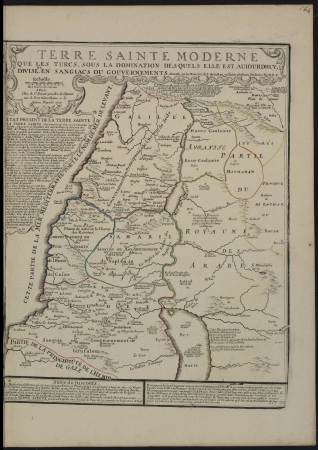
map of ancient armenia by philippe de la rué
bibliothèque nationale de france
die zee custe van tland van poictou ende bordeaux tuschen picqueliers ende de riviere van bordeaux alsoe hem tlant aldaer vuijt der zee opdoet ende verthoont - btv1b53156768t
bibliothèque nationale de france
midle-sex described with the most famous cities of london and westminster (1610)
context files from gallica
midle-sex described with the most famous cities of london and westminster (1610)
bibliothèque nationale de france
maps by willem and johannes blaeu
1630s maps of the americas
an accurate map of england and wales , drawn from all the particular surveys hitherto publish'd. illustrated with many additional improvements, and regulated by numerous astronomical observations made by... - btv1b53181614s
maps by thomas kitchin
maps by william home lizars
1836 maps of mexico
19th-century maps of vaucluse
1852 maps of france
self-published work
cc-pd-mark
die zee custe van tland van poictou ende bordeaux tuschen picqueliers ende de riviere van bordeaux alsoe hem tlant aldaer vuijt der zee opdoet ende verthoont - btv1b53156768t
bibliothèque nationale de france
die zee custe van tland van poictou ende bordeaux tuschen picqueliers ende de riviere van bordeaux alsoe hem tlant aldaer vuijt der zee opdoet ende verthoont - btv1b53156768t
bibliothèque nationale de france
map of ancient armenia by philippe de la rué
bibliothèque nationale de france
an accurate map of england and wales , drawn from all the particular surveys hitherto publish'd. illustrated with many additional improvements, and regulated by numerous astronomical observations made by... - btv1b53181614s
maps by thomas kitchin
a voyage to abyssinia, and travels into the interior of that country, executed under the orders of the british government in the years 1809 & 1810
john outhett
jean-fréderic phélypeaux
guillaume dheulland
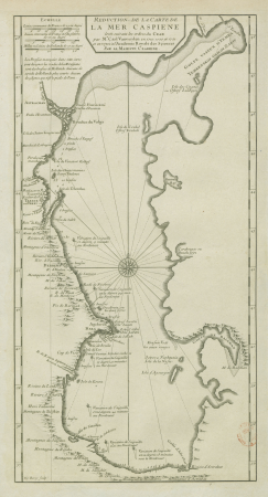
18th-century maps of the caspian sea
claude auguste berey
maps of the south atlantic
guillaume dheulland
amérique méridionale (1748, d'anville)
rococo
nice
good
bibliothèque nationale de france
maps by thomas kitchin
18th-century maps of kent
maps by thomas kitchin
old maps of northumberland
maps by thomas kitchin
photography (print room), leiden university library
photographs by emmy andriesse in amsterdam
woman
job
woman
job
map of the caspian sea by guillaume delisle (1720s)
maps by gerard valck
prints by james gillray in the british museum
satirical prints in the british museum
engravings from the bible in the rijksmuseum amsterdam
tower of babel in engravings
french-language maps
david du vivier
pages using duplicate arguments in template calls
teaching illustrations for language learning
nice
good
hippie
dove
16th-century maps of the persian gulf
16th-century maps of the red sea
16th-century paintings of cupid (eros)
de aetatibus mundi imagines
sanson maps of the netherlands
1670s maps of belgium
world war i posters in the library of congress
czech-language posters
cynara cardunculus scolymus group
elizabeth blackwell (illustrator)
illustrations for "evan harrington"
once a week magazine, 1860
children
school
christmas
food
bathroom
fun
historical
history
maps of the san francisco bay area
1854 maps of california
prints by william hogarth
realism
medical cartoons by james gillray
illustrations of gout
17th-century maps of the mediterranean sea
portolan charts made in the 17th century
1720s maps of palestine
nicolas de fer
17th-century maps of west africa
1650 maps of africa
17th-century maps of pembrokeshire
maps by jodocus hondius ii
landscape
building
historical
history
historical
history
major john andre monument
major john andré monument
french opera house, new orleans
1890 in new orleans
landscape
building
female portrait paintings by scipione pulzone
portraits of bianca cappello
old maps of the strait of gibraltar
hendrik de leth
maps published by hendrik de leth
algiers in the 18th century
françois de la pointe
maps of barbary coast
old maps of ancient israel
1720s maps of palestine
woman
lady
woman
job
de viris illustribus (petrarch)
beic classics of culture
myths of the hindus & buddhists illustrations
paintings by kshitindranath mazumdar
memorial stone dedicated to the murdered scout wacław siedlecki
plaques in białystok
prints by simon moulijn in the rijksmuseum amsterdam
lithographs in the rijksmuseum amsterdam
illustrations of jean de la fontaine's fables by grandville
symbolism
prints in the united states national library of medicine
unidentified salvia - botanical illustrations
album oeselscher bauerntrachten
art museum of estonia
wilhelm pleydenwurff
hartmann schedel
a voyage to abyssinia, and travels into the interior of that country, executed under the orders of the british government in the years 1809 & 1810
john outhett
balloon
school
1898 posters of france
eugène le mouël
the book of history. a history of all nations from the earliest times to the present, with over 8,000 illustrations
the campaign in india 1857-58 (1859)
maps of the byzantine levant
1650s maps showing history
woman
job
1855 posters of france
horace castelli
1892 posters of france
ferdinand bac
1900 posters of france
art nouveau
symbolism,decadent movement
le vice suprême
maps by john cary
1801 maps
a voyage to abyssinia, and travels into the interior of that country, executed under the orders of the british government in the years 1809 & 1810
john outhett
maps of ancient israel by philippe de la rué
henri le roy (1579-)
vue de caen capitale de la basse normandie . vue exécutée par les soins de philippe buache, sur les desseins de mr. de la londe - btv1b531816318
caen in art
maps by pieter mortier
maps from gallica
bibliothèque nationale de france
félix robaut
vue de caen capitale de la basse normandie . vue exécutée par les soins de philippe buache, sur les desseins de mr. de la londe - btv1b531816318
bibliothèque nationale de france
prints published by leonard schenk
bibliothèque nationale de france
context files from gallica
hendrik de leth
maps of the course of the rhine by guillaume sanson
guillaume sanson
prints by james gillray in the british museum
satirical prints in the british museum
lithographs in the cooper–hewitt, smithsonian design museum
posters in the cooper hewitt, smithsonian design museum
maps by william home lizars
1836 maps of texas
prints after philip fruytiers
jacob neefs
capsicum annuum - botanical illustrations
a curious herbal
15701 - 15800 of 16,773
Next page
/ 168


![Midle-Sex described with the most famous cities of London and Westminster / Described by Iohn Norden; Augme[n]ted by I. Speed; Jodocus Hondius caelavit, 1610](https://cdn.creazilla.com/illustrations/10001372370/midle-sex-described-with-the-most-famous-cities-of-london-and-westminster-described-by-iohn-norden-augmented-by-i-speed-jodocus-hondius-caelavit-1610-md.jpg)
![Midle-Sex described with the most famous cities of London and Westminster / Described by Iohn Norden; Augme[n]ted by I. Speed; Jodocus Hondius caelavit, 1610](https://cdn.creazilla.com/illustrations/10001324000/midle-sex-described-with-the-most-famous-cities-of-london-and-westminster-described-by-iohn-norden-augmented-by-i-speed-jodocus-hondius-caelavit-1610-md.jpg)


![An accurate Map of Dorset shire: drawn from the best maps charts etc. & regulated by astron[omy] observ[atio]ns / by T. Kitchin, Thomas Kitchin](https://cdn.creazilla.com/illustrations/10000227853/an-accurate-map-of-dorset-shire-drawn-from-the-best-maps-charts-etc-regulated-by-astronomy-observations-by-t-kitchin-thomas-kitchin-md.jpg)