Log in
All resources
Create a design
16,781 Free Images of Language
bibliothèque nationale de france
carte generale du tres-haut, tres-puissant et tres chrestien royaume de france
alphabet
english language
ornament
eran laor cartographic collection
italia - di matteo greuter - btv1b53041991c
body language
heart
love
drawings (print room), leiden university library
ars aemula naturae, leiden university library
😃 emoji
alphabet
forbidden
😃 emoji
😃 emoji
woman
😃 emoji
man
😃 emoji
victory
1660s maps of france
maps of lyonnais
maps of the islands of greece by marco boschini (1658)
context files from gallica
military history of the british empire
j. r. skelton
alfred-henri darjou
ornament
heart
ornament
heart
ornament
heart
ornament
heart
comic
sound
ornament
wine
peace sign
elbow
ornament
heart
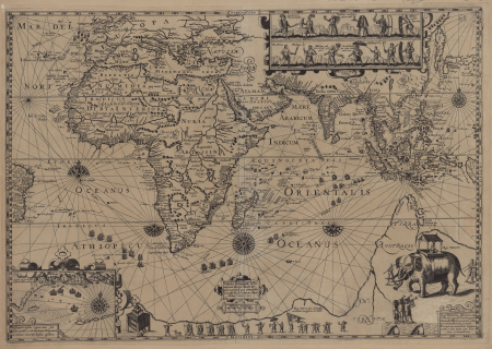
1836 maps of africa
ambroise tardieu
map of the upper rhenian circle by sanson
1680s maps of north rhine-westphalia
prints (print room), leiden university library
poseidon in art
prints (print room), leiden university library
prints by johannes josephus aarts
19th-century maps of nièvre
1852 maps of france
ensor (delteil 097)
taking physick
chorographia britanniae (1741-1742)
18th-century maps of cornwall
eran laor cartographic collection
claes jansz. visscher (ii)
eran laor cartographic collection
claes jansz. visscher (ii)
chorographia britanniae (1741-1742)
18th-century maps of kent
1600 maps of africa
benjamin wright
plants
tree
wmf agora icon set
keyboard icons
a rapid french course for students in evening classes, private students, and others (1917)
historical images of monument à la république
abel faivre
carte de la prevoste et vicomte de paris by guillaume delisle (1711)
atlas géographique des quatre parties du monde (delisle)
presa delle dua galere di biserta fatta dalle galere della sacra relig(io)ne di s. stefano ( ) - stefan(o) della bella f(ecit) - btv1b531704111
baroque
carte generale du tres-haut, tres-puissant et tres chrestien royaume de france
bibliothèque nationale de france
italia - di matteo greuter - btv1b53041991c
bibliothèque nationale de france
le duché de clèves, la seigneurie de ravenstein et le comté de meurs... - par le sr sanson... - btv1b53202428c
guillaume sanson
les duchés de cleves, juliers, limbourg (etc.) by jaillot
bibliothèque nationale de france
carte de barbarie, nigritie, guinée par guillaume delisle (1707)
bibliothèque nationale de france
carte generale du tres-haut, tres-puissant et tres chrestien royaume de france
bibliothèque nationale de france
carte generale du tres-haut, tres-puissant et tres chrestien royaume de france
bibliothèque nationale de france
presa delle dua galere di biserta fatta dalle galere della sacra relig(io)ne di s. stefano ( ) - stefan(o) della bella f(ecit) - btv1b531704111
baroque
1667 map of madagascar by guillaume sanson
bibliothèque nationale de france
nelle presenti tre tavole sono descritte le marine secondo le carte da navicar et fra terra secondo i migliori scrittori antichi et moderni, con fumi, monti, laghi, mari, citta, provincie et capi principale... - btv1b8468487h
bibliothèque nationale de france
bibliothèque nationale de france
tranquillo mollo
sanson maps of the circles of germany
1670s maps of baden-württemberg
lettre autographe signée d'andré saglio, dit drésa, à jacques rouché, 26 mars 1918 (manuscrit autographe) - btv1b53150675f
bibliothèque nationale de france
carte generale du tres-haut, tres-puissant et tres chrestien royaume de france
bibliothèque nationale de france
maps from gallica
guides joanne
bibliothèque nationale de france
guillaume sanson
presa delle dua galere di biserta fatta dalle galere della sacra relig(io)ne di s. stefano ( ) - stefan(o) della bella f(ecit) - btv1b531704111
baroque
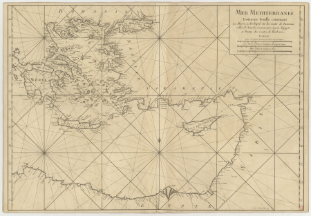
carte de la mer méditerranée en trois feuilles (dheulland et al.)
18th-century maps of the eastern mediterranean
carte generale du tres-haut, tres-puissant et tres chrestien royaume de france
bibliothèque nationale de france
italia - di matteo greuter - btv1b53041991c
bibliothèque nationale de france
carte generale du tres-haut, tres-puissant et tres chrestien royaume de france
bibliothèque nationale de france
map of modern syria by philippe de la rué
bibliothèque nationale de france
italia - di matteo greuter - btv1b53041991c
bibliothèque nationale de france
carte generale du tres-haut, tres-puissant et tres chrestien royaume de france
bibliothèque nationale de france
italia - di matteo greuter - btv1b53041991c
bibliothèque nationale de france
john rocque's 1748 map of london and adjacent country
remigius parr
italia - di matteo greuter - btv1b53041991c
bibliothèque nationale de france
map of modern syria by philippe de la rué
bibliothèque nationale de france
carte generale du tres-haut, tres-puissant et tres chrestien royaume de france
bibliothèque nationale de france
carte generale du tres-haut, tres-puissant et tres chrestien royaume de france
bibliothèque nationale de france
carte generale du tres-haut, tres-puissant et tres chrestien royaume de france
bibliothèque nationale de france
18th-century maps of the strait of magellan
1700s maps of argentina
book covers from the netherlands
covers of books about history
building
tools
unidentified locations in scotland
scotland's story by h. e. marshall
maps of capelle (nord)
old maps of vermandois
eran laor cartographic collection
willem albert bachiene
eran laor cartographic collection
willem albert bachiene
1840s maps of the world
german renaissance
maps of ardales by braun & hogenberg
17th-century engravings of towns
eran laor cartographic collection
claes jansz. visscher (ii)
high renaissance
oronce fine
eran laor cartographic collection
claes jansz. visscher (ii)
17th-century maps of vienna
bartholomeo camuccio
prints by martin engelbrecht
18th-century maps of vienna
17th-century maps of dorset
maps by john speed
scotland's story by h. e. marshall
edinburgh in the 17th century
sanskrit-language manuscripts
19th-century manuscripts
latin-language maps
german renaissance
historical
history
historical
history
historical
history
historical
history
historical
history
carte generale du tres-haut, tres-puissant et tres chrestien royaume de france
bibliothèque nationale de france
bibliothèque nationale de france
1698 map of evesché de meaux
nelle presenti tre tavole sono descritte le marine secondo le carte da navicar et fra terra secondo i migliori scrittori antichi et moderni, con fumi, monti, laghi, mari, citta, provincie et capi principale... - btv1b8468487h
bibliothèque nationale de france
carte generale du tres-haut, tres-puissant et tres chrestien royaume de france
bibliothèque nationale de france
italia - di matteo greuter - btv1b53041991c
bibliothèque nationale de france
bibliothèque nationale de france
hendrik de leth
carte generale du tres-haut, tres-puissant et tres chrestien royaume de france
bibliothèque nationale de france
georg balthasar probst (1732-1801)
bibliothèque nationale de france
presa delle dua galere di biserta fatta dalle galere della sacra relig(io)ne di s. stefano ( ) - stefan(o) della bella f(ecit) - btv1b531704111
baroque
presa delle dua galere di biserta fatta dalle galere della sacra relig(io)ne di s. stefano ( ) - stefan(o) della bella f(ecit) - btv1b531704111
baroque
14201 - 14300 of 16,781
Next page
/ 168


![Isolette [Raclia, Schinussa, etc] / Marco Boschini, 1658](https://cdn.creazilla.com/illustrations/10001438226/isolette-raclia-schinussa-etc-marco-boschini-1658-sm.webp)


![Capture of the two galleys of Biserta by the galleys of the Sacred Relig[ion] of St. Stephen [ ] / Stefan[o] of the Beautiful f[ecit], 1628](https://cdn.creazilla.com/illustrations/10000199137/capture-of-the-two-galleys-of-biserta-by-the-galleys-of-the-sacred-religion-of-st-stephen-stefano-of-the-beautiful-fecit-1628-sm.webp)


![Capture of the two galleys of Biserta by the galleys of the Sacred Relig[ion] of St. Stephen [ ] / Stefan[o] of the Beautiful f[ecit], 1628](https://cdn.creazilla.com/illustrations/10000553802/capture-of-the-two-galleys-of-biserta-by-the-galleys-of-the-sacred-religion-of-st-stephen-stefano-of-the-beautiful-fecit-1628-sm.webp)


![Capture of the two galleys of Biserta by the galleys of the Sacred Relig[ion] of St. Stephen [ ] / Stefan[o] of the Beautiful f[ecit], 1628](https://cdn.creazilla.com/illustrations/10000664627/capture-of-the-two-galleys-of-biserta-by-the-galleys-of-the-sacred-religion-of-st-stephen-stefano-of-the-beautiful-fecit-1628-sm.webp)


![Map of Paraguay, Chile, and Strait of Magellan - Guillaume de L'Isle, [1703-1708]](https://cdn.creazilla.com/illustrations/10001534848/map-of-paraguay-chile-and-strait-of-magellan-guillaume-de-lisle-1703-1708-sm.webp)


![Totius Galliae Descriptio cum parte Angliae, Germaniae, Flandriae, Brabantiae, Italiae Romam usque, Pyrrho Ligoric Neap. auctore. [1: 3 585 000 environ]. Sebastianus a Regibus Clodiensis incidebat, Pirro Ligorio, 1558](https://cdn.creazilla.com/illustrations/10000285804/totius-galliae-descriptio-cum-parte-angliae-germaniae-flandriae-brabantiae-italiae-romam-usque-pyrrho-ligoric-neap-auctore-1-3-585-000-environ-sebastianus-a-regibus-clodiensis-incidebat-pirro-ligorio-1558-md.jpg)


![Modern Jerusalem / Georg Balthasar Probst print[it], Georg Balthasar Probst](https://cdn.creazilla.com/illustrations/10001069714/modern-jerusalem-georg-balthasar-probst-print-it-georg-balthasar-probst-md.jpg)
![Capture of the two galleys of Biserta by the galleys of the Sacred Relig[ion] of St. Stephen [ ] / Stefan[o] of the Beautiful f[ecit], 1628](https://cdn.creazilla.com/illustrations/10000566148/capture-of-the-two-galleys-of-biserta-by-the-galleys-of-the-sacred-relig-ion-of-st-stephen-stefan-o-of-the-beautiful-f-ecit-1628-sm.jpg)
![Capture of the two galleys of Biserta by the galleys of the Sacred Relig[ion] of St. Stephen [ ] / Stefan[o] of the Beautiful f[ecit], 1628](https://cdn.creazilla.com/illustrations/10000740279/capture-of-the-two-galleys-of-biserta-by-the-galleys-of-the-sacred-religion-of-st-stephen-stefano-of-the-beautiful-fecit-1628-sm.webp)