Log in
All resources
Create a design
16,781 Free Images of Language
bibliothèque nationale de france
flora by h. witte (pngs)
chromolithograph
hortus botanicus leiden
abraham jacobus wendel
context files from gallica
maps of the islands of greece by marco boschini (1658)
marco boschini
history
historical
ornament
wine
ornament
wine
martin david roth
matthias norberg
juan de la cruz cano y olmedilla
1755 maps of north america
pieter van der keere
history of brabant
18th-century maps of istanbul
maps from gallica
high renaissance
pirro ligorio
dutch-language banners
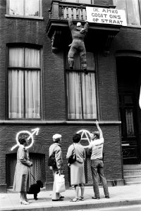
lucky luyk
maps of wissembourg by braun & hogenberg
maps of colmar by braun & hogenberg
speaker
tie
maps of île-de-france by françois de la guillotière
context files from gallica
old maps of lazio
henry le roy
self-published work
wtfpl
historical
history
historical
history
historical
history
maps of the islands of greece by marco boschini (1658)
context files from gallica
old maps of bourbonnais
1660s maps of france
maps by hendrik hondius the younger
1632 maps of africa
maps of the peloponnese by gerardus mercator
1640s maps of greece
old maps of the nordic region
1840 maps
19th-century double hemisphere world maps
1800s maps of the world
historical
history
historical
history
historical
history
historical
history
historical
history
self-published work
black discs
maps by pieter van der keere
old maps of friesland
context files from gallica
veľký šariš
flora by h. witte (pngs)
ampelopsis glandulosa
old maps of antikythera
old maps of kythira
maps by thomas starling
1842 maps
maps of the islands of greece by marco boschini (1658)
old maps of lesbos
passiflora 'imperatrice eugenie'
flora by h. witte (pngs)
maps of the islands of greece by marco boschini (1658)
history of lesbos
symbol
school
gesture
hands
liriodendron tulipifera - botanical illustrations
flora by h. witte (pngs)
chorographia britanniae (1741-1742)
england in the 1740s
maps of alhama de granada by braun & hogenberg
bibliothèque nationale de france
bibliothèque nationale de france
guillaume sanson
anemone coronaria - botanical illustrations
flora by h. witte (pngs)
a map of the british empire in america with the french and spanish settlements adjacent thereto
bibliothèque nationale de france
a map of the british empire in america with the french and spanish settlements adjacent thereto
bibliothèque nationale de france
phacelia minor - botanical illustrations
flora by h. witte (pngs)
a map of the british empire in america with the french and spanish settlements adjacent thereto
bibliothèque nationale de france
maps by emanuel bowen
1740 maps
paeonia suffruticosa - botanical illustrations
flora by h. witte (pngs)
erythronium albidum - botanical illustrations
flora by h. witte (pngs)
tanacetum coccineum - botanical illustrations
flora by h. witte (pngs)
magnolia × soulangeana - botanical illustrations
flora by h. witte (pngs)
america, quarta pars orbis (quam plerunque novum orbem appellitand) primo detecta est anno 1492... - c. visscher, excudit - btv1b7200220t
bibliothèque nationale de france
maps of schwäbisch hall by braun & hogenberg
bibliothèque nationale de france
kniphofia uvaria - botanical illustrations
flora by h. witte (pngs)
a map of the british empire in america with the french and spanish settlements adjacent thereto
bibliothèque nationale de france
1750s maps of the caribbean
maps by thomas kitchin
maps of the islands of greece by marco boschini (1658)
old maps of psarà
america, quarta pars orbis (quam plerunque novum orbem appellitand) primo detecta est anno 1492... - c. visscher, excudit - btv1b7200220t
bibliothèque nationale de france
maps by willem and johannes blaeu
17th-century maps of dombes
orbis pictus
dictamnus albus - botanical illustrations
flora by h. witte (pngs)
maps of barbary coast by mercator-hondius
bibliothèque nationale de france
cyclamen hederifolium - botanical illustrations
flora by h. witte (pngs)
america, quarta pars orbis (quam plerunque novum orbem appellitand) primo detecta est anno 1492... - c. visscher, excudit - btv1b7200220t
bibliothèque nationale de france
bibliothèque nationale de france
guillaume sanson
maps of formia by braun & hogenberg
bibliothèque nationale de france
maps of rügen by eilhard lubinus
bibliothèque nationale de france
maps of ancient italy by philipp clüver
bibliothèque nationale de france
primula meadia - botanical illustrations
flora by h. witte (pngs)
chorographia britanniae (1741-1742)
bibliothèque nationale de france
territorium argentoratense (1652 map)
context files from gallica
maps of dordrecht by braun & hogenberg
bibliothèque nationale de france
maps of münstermaifeld by braun & hogenberg
maps of cochem by braun & hogenberg
regnorum hispaniae nova descriptio (blaeu)
spain in the 1640s
maps of bamberg by braun & hogenberg
bibliothèque nationale de france
regnorum hispaniae nova descriptio (blaeu)
spain in the 1640s
maps of nové zámky by braun & hogenberg
maps of visegrád by braun & hogenberg
descriptio daciarum (17th-century map)
maps by pieter van der keere
platycodon grandiflorus - botanical illustrations
flora by h. witte (pngs)
maps of the islands of greece by marco boschini (1658)
context files from gallica
america, quarta pars orbis (quam plerunque novum orbem appellitand) primo detecta est anno 1492... - c. visscher, excudit - btv1b7200220t
bibliothèque nationale de france
campsis grandiflora - botanical illustrations
flora by h. witte (pngs)
bibliothèque nationale de france
guillaume sanson
maps from gallica
old maps of rome
our empire story by h. e. marshall
j. r. skelton
context files from gallica
history of rhodes
maps of the islands of greece by marco boschini (1658)
context files from gallica
17th-century maps of the netherlands
maps by pieter van der keere
old maps of the shetland islands
old maps of the orkney islands
1650s maps of switzerland
hans conrad gyger
16th-century maps of crete
old maps of candia
17th-century maps of savoie
old maps of savoie
maps of ancient italy by philipp clüver
maps of samnium
maps of the islands of greece by marco boschini (1658)
history of kythira
context files from gallica
history of samos
maps of blois by braun & hogenberg
urbanisation in loir-et-cher
maps of the kingdom of seville
maps of spain by tomas lopez
landais & oberthur
maps from gallica
maps of the kingdom of córdoba (crown of castile)
maps of spain by tomas lopez
13201 - 13300 of 16,781
Next page
/ 168


![Sabinorum et Marsorum agri descriptio. 11; Typus utriusque Latii [...]. 8 / auctore Philippo Cluverio; H. Le Roy fecit, 1624](https://cdn.creazilla.com/illustrations/10001535937/sabinorum-et-marsorum-agri-descriptio-11-typus-utriusque-latii-8-auctore-philippo-cluverio-h-le-roy-fecit-1624-sm.webp)


![Zaros Superioris Hungariae civitas et propugnaculum / Communicavit Georgius Houfnaglius A[nn]o 1617, Joris Hoefnagel, 1635](https://cdn.creazilla.com/illustrations/10000741763/zaros-superioris-hungariae-civitas-et-propugnaculum-communicavit-georgius-houfnaglius-a-nn-o-1617-joris-hoefnagel-1635-sm.jpg)


![An Alphabetical List of all the Cities, Boroughs, & Market Towns in England & Wales / [Badeslade]; W.H. Toms sculp., 1741](https://cdn.creazilla.com/illustrations/10000199143/an-alphabetical-list-of-all-the-cities-boroughs-market-towns-in-england-wales-badeslade-wh-toms-sculp-1741-md.jpg)
![Amoenissimus castri Granatensis, vulgo Alhambre dicti, ab Oriente prospectus / Effigiabat Georgius Hufnagli[us] anno dnj 1564, between 1564 and 1640](https://cdn.creazilla.com/illustrations/10000300894/amoenissimus-castri-granatensis-vulgo-alhambre-dicti-ab-oriente-prospectus-effigiabat-georgius-hufnaglius-anno-dnj-1564-between-1564-and-1640-md.jpg)


![A Table of the High Roads through England and Wales.Tab.2. to follow Plate 3 / [Badeslade]; W.H. Toms sculp., 1741](https://cdn.creazilla.com/illustrations/10001464220/a-table-of-the-high-roads-through-england-and-walestab2-to-follow-plate-3-badeslade-wh-toms-sculp-1741-sm.webp)


![Owar, germanice Nieuhuisel; Vizzegrad, germanice Plindeburg / Communicavit G. Houfnaglius depict. a filio a[nn]o 1595, between 1595 and 1640](https://cdn.creazilla.com/illustrations/10001244849/owar-germanice-nieuhuisel-vizzegrad-germanice-plindeburg-communicavit-g-houfnaglius-depict-a-filio-anno-1595-between-1595-and-1640-md.jpg)


![Map of the department of Ille & Vilaine / published [...] by Landais & Oberthur, lithographers; with the assistance of Mr. G. Corbe, chief road agent of the dept., 1847](https://cdn.creazilla.com/illustrations/10000314825/map-of-the-department-of-ille-vilaine-published-by-landais-oberthur-lithographers-with-the-assistance-of-mr-g-corbe-chief-road-agent-of-the-dept-1847-sm.webp)
