Log in
All resources
Create a design
8,202 Free Images of Documentary
bibliothèque nationale de france
marco boschini
maps of the islands of greece by marco boschini (1658)
maps of ports and fortresses of the mediterranean by marco boschini (1651)
context files from gallica
maps by pieter van der keere
city
streets
town
candid
maps by pieter van der keere
maps with cartouches
maps of the islands of greece by marco boschini (1658)
old maps of sifnos
maps of the magellan straits by lambert cornelis
bibliothèque nationale de france
chorographia britanniae (1741-1742)
1741 in england
vehicle
winter
maps of the islands of greece by marco boschini (1658)
history of lemnos
maps of the magellan straits by lambert cornelis
context files from gallica
maps of the islands of greece by marco boschini (1658)
context files from gallica
maps by willem and johannes blaeu
robert gordon of straloch
maps of the islands of greece by marco boschini (1658)
old maps of skyros
maps of the islands of greece by marco boschini (1658)
old maps of chios
maps of the islands of greece by marco boschini (1658)
old maps of lemnos
derivative works of vitruvian man
high renaissance,renaissance
maps by pieter van der keere
old maps of bohemia
bibliothèque nationale de france
novus atlas sinensis
territorium argentoratense (1652 map)
bibliothèque nationale de france
napoleon iii of france in art
napoléon louis bonaparte
emperor alexander ii declares the diet of 1863 opened
dais
vehicle
winter
summer
people
travel
city
maps by pieter van der keere
ships on maps
maps of the islands of greece by marco boschini (1658)
kinaros
map of the circle of austria by sanson
1670s maps of austria
map of the circle of austria by sanson
1670s maps of austria
vehicle
winter
maps of the islands of greece by marco boschini (1658)
context files from gallica
1620s maps of the netherlands
maps by pieter van der keere
maps of the islands of greece by marco boschini (1658)
context files from gallica
maps of alsace by guillaume sanson
1690s maps of alsace
1690s maps of baden-württemberg
1690s maps of alsace
claude auguste berey
henri liébaux
maps of ports and fortresses of the mediterranean by marco boschini (1651)
bibliothèque nationale de france
maps of the islands of greece by marco boschini (1658)
old maps of karpathos
maps of ports and fortresses of the mediterranean by marco boschini (1651)
bibliothèque nationale de france
maps from gallica
guides joanne
bibliothèque nationale de france
guillaume sanson
1667 map of madagascar by guillaume sanson
bibliothèque nationale de france
maps of the islands of greece by marco boschini (1658)
old maps of skiathos
maps of ports and fortresses of the mediterranean by marco boschini (1651)
bibliothèque nationale de france
maps of ports and fortresses of the mediterranean by marco boschini (1651)
bibliothèque nationale de france
maps of ports and fortresses of the mediterranean by marco boschini (1651)
bibliothèque nationale de france
maps of ports and fortresses of the mediterranean by marco boschini (1651)
bibliothèque nationale de france
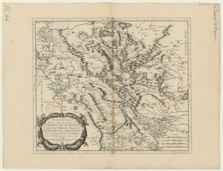
1660s maps of rhineland-palatinate
maps of vangiones by sanson
maps of ports and fortresses of the mediterranean by marco boschini (1651)
bibliothèque nationale de france
maps of ports and fortresses of the mediterranean by marco boschini (1651)
bibliothèque nationale de france
maps of ports and fortresses of the mediterranean by marco boschini (1651)
bibliothèque nationale de france
bibliothèque nationale de france
guillaume sanson
maps of ports and fortresses of the mediterranean by marco boschini (1651)
bibliothèque nationale de france
maps of ports and fortresses of the mediterranean by marco boschini (1651)
bibliothèque nationale de france
1650s maps of the atlantic ocean
joan blaeu
maps from gallica
guides joanne
maps of ports and fortresses of the mediterranean by marco boschini (1651)
bibliothèque nationale de france
maps of the islands of greece by marco boschini (1658)
old maps of astypalaia
bibliothèque nationale de france
ambroise tardieu
maps of brest from bibliothèque nationale de france
lithographs of brest, france
context files from gallica
history of folegandros
historical
history
maps of the history of jerusalem
1830s maps showing history
old maps of folegandros
old maps of sikinos
chorographia britanniae (1741-1742)
bibliothèque nationale de france
maps of the islands of greece by marco boschini (1658)
old maps of serifos
chorographia britanniae (1741-1742)
bibliothèque nationale de france
old maps of auvergne
1660s maps of france
maps of the islands of greece by marco boschini (1658)
history of tinos
maps of the islands of greece by marco boschini (1658)
history of serifos
maps of the islands of greece by marco boschini (1658)
context files from gallica
serenissimae reipublicae genuensis ducatus et dominii nova descriptio - gio. bat.ta vrints - btv1b53042587g
bibliothèque nationale de france
claes jansz. visscher (ii)
maps of amsterdam
maps of brussels by braun & hogenberg
bibliothèque nationale de france
maps of the islands of greece by marco boschini (1658)
old maps of tinos
maps of ancient italy by philipp clüver
bibliothèque nationale de france
maps by pieter van der keere
17th-century maps of silesia
giovanni antonio agostini
beweb
maps of bologna by braun & hogenberg
bibliothèque nationale de france
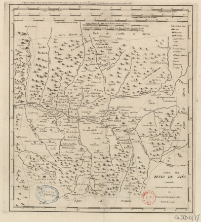
maps of the kingdom of jaén (crown of castile)
maps of spain by tomas lopez
vigo in the 18th century
1702 maps of spain
18th-century maps of japan
works after jan goeree
olga nikolaevna of russia in art
infant baptism in art
maps of raucourt
maps of sedan
alexander i of russia in documentary paintings
william i of the netherlands in art
maps of vangiones by sanson
1670s maps of hesse
maps by willem and johannes blaeu
17th-century maps of xaintonge
bibliothèque nationale de france
mapa general de españa (1802)
l'alsace divisée en ses principales parties, dressée sur les mémoires les plus nouveaux - par le sr.sanson... - btv1b530329041
guillaume sanson
bibliothèque nationale de france
guillaume dheulland
bibliothèque nationale de france
mapa general de españa (1802)
bibliothèque nationale de france
gaetano bianchi
carte des alpes by guillaume sanson (1690)
bibliothèque nationale de france
carte des alpes by guillaume sanson (1690)
bibliothèque nationale de france
carte des alpes by guillaume sanson (1690)
bibliothèque nationale de france
carte des alpes by guillaume sanson (1690)
bibliothèque nationale de france
bibliothèque nationale de france
joachim ottens
old maps of nagasaki
guillaume dheulland
maps of ports and fortresses of the mediterranean by marco boschini (1651)
bibliothèque nationale de france
17th-century maps of xaintonge
maps by jodocus hondius ii
l'alsace divisée en ses principales parties, dressée sur les mémoires les plus nouveaux - par le sr.sanson... - btv1b530329041
guillaume sanson
bibliothèque nationale de france
mapa general de españa (1802)
map of italy by guillaume delisle (1700)
bibliothèque nationale de france
17th-century maps of venezuela
johannes leupenius
7801 - 7900 of 8,202
Next page
/ 83


![Map of Thrace to aid in understanding Roman history / by Henri Liébaux, geographer; C[laude] A[uguste] De Berey, sculp[sit], Claude Auguste Berey, 1727](https://cdn.creazilla.com/illustrations/10001256073/map-of-thrace-to-aid-in-understanding-roman-history-by-henri-libaux-geographer-claude-auguste-de-berey-sculpsit-claude-auguste-berey-1727-sm.webp)


![Thine / [par Marco Boschini], Marco Boschini, 1651](https://cdn.creazilla.com/illustrations/10001280866/thine-par-marco-boschini-marco-boschini-1651-sm.webp)


![Patent of invention. Terrestrial globe [diam. Om. 36] / drawn up by Ambroise Tardieu after the invention of A. Weinling and Co., Ambroise Tardieu, 1831](https://cdn.creazilla.com/illustrations/10001597982/patent-of-invention-terrestrial-globe-diam-om-36-drawn-up-by-ambroise-tardieu-after-the-invention-of-a-weinling-and-co-ambroise-tardieu-1831-sm.webp)


![A Table of all the Cross Roads in England and Wales.To follow Plate 4 / [Badeslade]; W.H. Toms sculp., 1741](https://cdn.creazilla.com/illustrations/10001514902/a-table-of-all-the-cross-roads-in-england-and-walesto-follow-plate-4-badeslade-wh-toms-sculp-1741-sm.webp)


![Rock and For[tez]za of Garabuse / by Marco Boschini, Marco Boschini, 1651](https://cdn.creazilla.com/illustrations/10000518564/rock-and-fortezza-of-garabuse-by-marco-boschini-marco-boschini-1651-md.jpg)


